Deep space exploration aircraft inertia-astronomical integrated navigation method

A technology for integrated navigation and deep space exploration, applied in integrated navigator, surveying and navigation, navigation through speed/acceleration measurement, etc., can solve the problem of unavailable magnetometer

Active Publication Date: 2020-05-19
SHANGHAI AEROSPACE CONTROL TECH INST
View PDF8 Cites 0 Cited by
  • Summary
  • Abstract
  • Description
  • Claims
  • Application Information

AI Technical Summary

Problems solved by technology

However, GNSS compatible machines and magnetometers are not available for deep spac

Method used


Image

  • Deep space exploration aircraft inertia-astronomical integrated navigation method
  • Deep space exploration aircraft inertia-astronomical integrated navigation method
  • Deep space exploration aircraft inertia-astronomical integrated navigation method

Examples


Embodiment Construction

[0063] The following will clearly and completely describe the technical solutions in the embodiments of the present invention with reference to the accompanying drawings in the embodiments of the present invention. Obviously, the described embodiments are only some of the embodiments of the present invention, not all of them. Based on the embodiments of the present invention, all other embodiments obtained by persons of ordinary skill in the art without making creative efforts belong to the protection scope of the present invention.

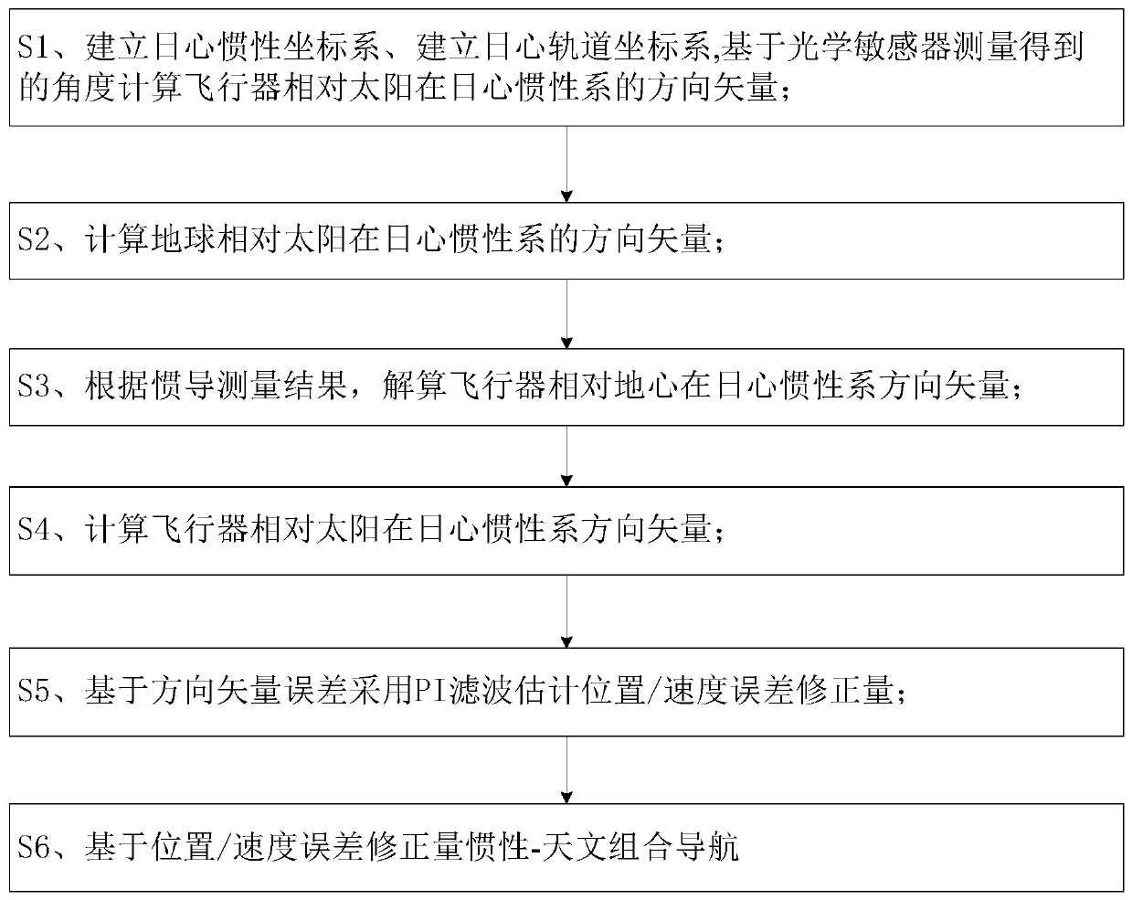
[0064] The present invention provides a deep space exploration aircraft inertial-astronomical integrated navigation method, such as image 3 shown, including the steps:

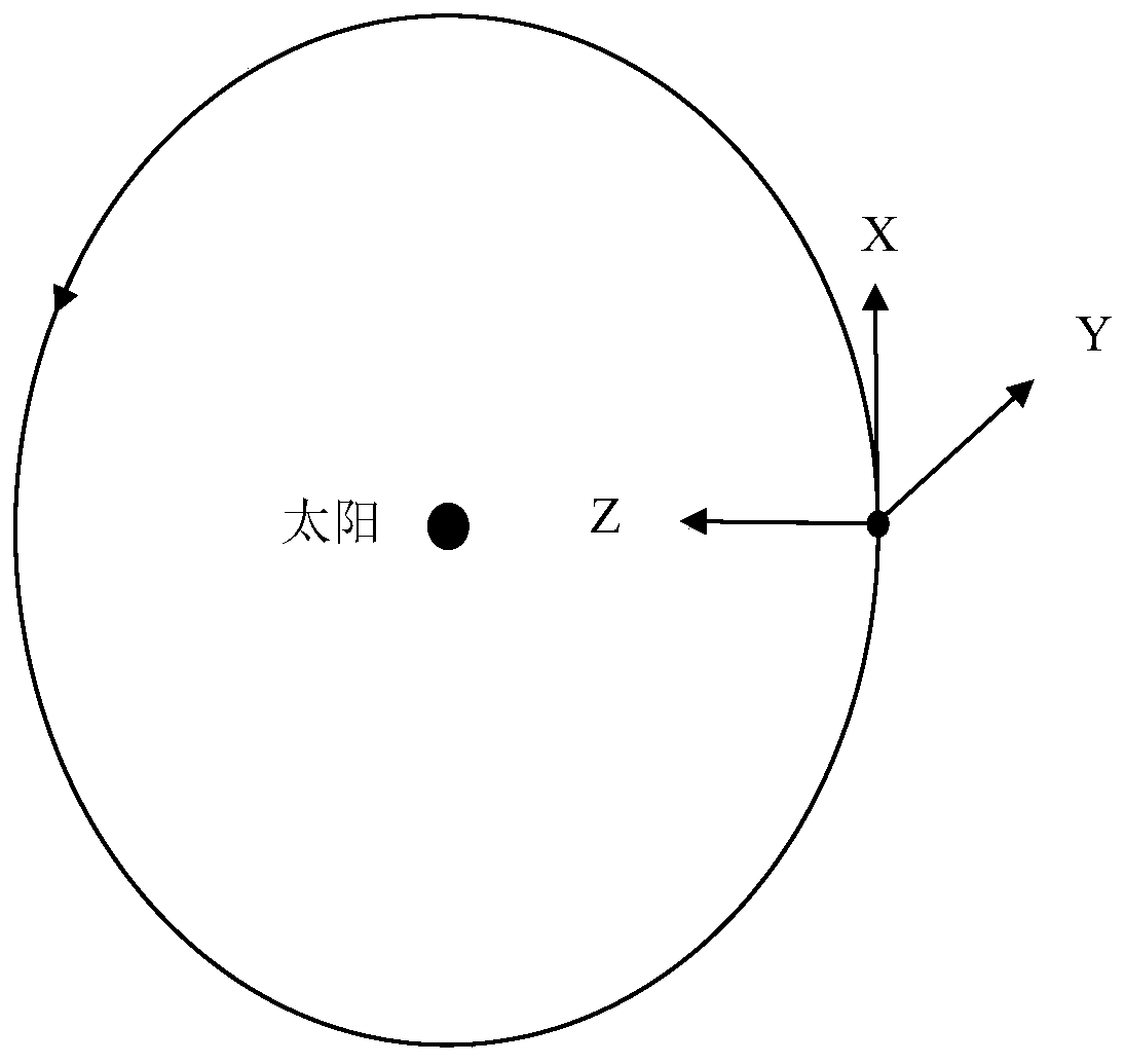
[0065] S1. Establish a heliocentric inertial coordinate system. The specific method is: take the sun as the origin, the X axis points to the J2000 equinox, the Z axis points to the center of the earth, and the Y axis is determined according to the right-hand rule.

[0066] Esta...


PUM


Abstract

The invention provides a deep space exploration aircraft inertia-astronomical integrated navigation method which comprises the following steps: S1, establishing a heliocentric inertial coordinate system, establishing a heliocentric orbit coordinate system, and calculating a direction vector of an aircraft relative to the sun in the heliocentric inertial system based on an angle measured by an optical sensor; S2, calculating a direction vector of the earth relative to the sun in a heliocentric inertial system; S3, resolving a direction vector of the aircraft relative to the earth center in theheliocentric inertial system according to the inertial navigation measurement result; S4, calculating the direction vector of the aircraft relative to the sun in the heliocentric inertial system; S5,estimating a position/speed error correction amount by adopting PI filtering based on the direction vector error; and S6, performing inertial-astronomical integrated navigation based on the position/speed error correction amount. According to the deep space exploration aircraft inertia-astronomical integrated navigation method, inertial navigation accumulative errors can be inhibited when the aircraft performs on-orbit real-time navigation.

Description

technical field [0001] The invention relates to the technical field of deep space astronomical navigation, in particular to an inertial-astronomical combined navigation method for a deep space exploration aircraft based on a star sensor and an optical sensor, which is used for on-orbit real-time navigation of the aircraft. Background technique [0002] Because the existing earth satellites and lunar exploration vehicles are closer to the earth, the ground measurement and control delay is shorter, and more sensors are available for the establishment of the ground measurement and control link, and the reliability of ground orbit determination is high. The deep space exploration aircraft is far away from the earth, and the ground measurement and control delay is sometimes as long as 30 minutes. The ground measurement orbit requires a reliable device-ground measurement and control link. of establishment. [0003] During the in-orbit operation of the aircraft, not only the attit...

Claims


Application Information

Patent Timeline
IPC IPC(8): G01C21/16G01C21/20G01C21/24
CPCG01C21/165G01C21/20G01C21/24
Inventor 王献忠张肖刘宇张国柱张丽敏施常勇刘赟
Owner SHANGHAI AEROSPACE CONTROL TECH INST
Why Eureka
Try Eureka