InSAR residual motion error estimation method and device considering topographic relief

A motion error and terrain technology, applied in the field of synthetic aperture radar interferometry, can solve problems such as distorted elevation information and RME difficult to estimate accurately

Active Publication Date: 2020-06-12
CENT SOUTH UNIV
View PDF12 Cites 12 Cited by
  • Summary
  • Abstract
  • Description
  • Claims
  • Application Information

AI Technical Summary

Problems solved by technology

However, in fact, there are unavoidable terrain fluctuations in the scene. On the one hand, the phase error characteristics caused by RMEs will be covered by the terrain phase, making it difficult to estimate RME accurately. On the other hand, the mutual coupling between RMEs and terrain will further distort the real Elevation information for

Method used


Image

  • InSAR residual motion error estimation method and device considering topographic relief
  • InSAR residual motion error estimation method and device considering topographic relief
  • InSAR residual motion error estimation method and device considering topographic relief

Examples


Embodiment Construction

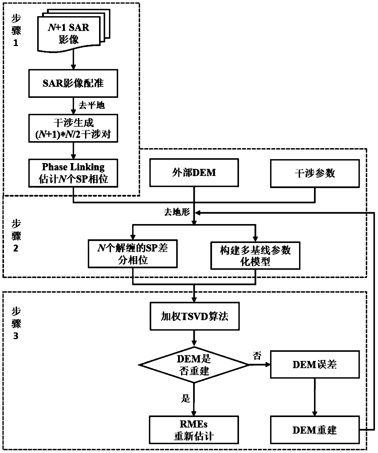
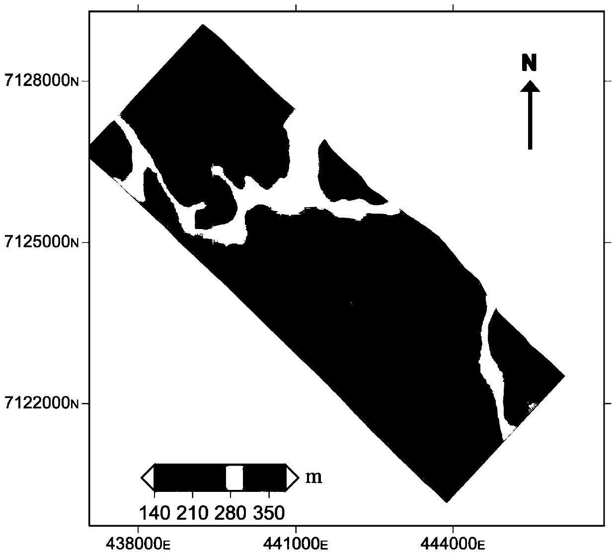
[0082] In order to make the purpose of the present invention, technical solutions and advantages thereof clearer, adopt the P-band multi-baseline data obtained during the flight test in 2008 by the airborne E-SAR system of German Aeronautics and Space Agency, the specific parameters are shown in attached table 1, for the present invention Explain in depth and detail. The topographic relief of the SAR image data coverage area is 150-380m above sea level, and this area is a typical vegetation coverage area, with an average tree height of 18m and the highest tree height of 30m. Due to the strong penetrability of the P-band, a large part of the DEM error is contributed by the difference in the phase center of the vegetation. The specific implementation cases described here are only used to explain the present invention, and are not intended to limit the present invention.

[0083] Based on the P-band multi-baseline interferometric data of the airborne E-SAR system adopted above, ...


PUM


Abstract

The invention discloses an InSAR residual motion error estimation method and device considering topographic relief, and the method comprises the steps: obtaining a multi-scene SAR image, carrying outpreprocessing, and calculating a topographic phase comprising an InSAR residual motion error; calculating a simulated terrain phase by using the external DEM data; solving the difference between the terrain phase containing the InSAR residual motion error and the simulated terrain phase, carrying out the phase unwrapping of the difference, and taking the unwrapped differential interferometric phase as an observation value; constructing a differential interferometric phase parameterization model related to InSAR interferometric geometric parameters, DEM errors and baseline error components; foreach distance row pixel of each slave image, matching the observation value of the differential interferometric phase with a differential interferometric phase parameterization model to construct anequation to obtain an observation equation; and solving DEM errors and baseline error components in the multi-baseline observation equation set. The invention can accurately estimate the residual motion error.

Description

technical field [0001] The invention belongs to the technical field of synthetic aperture radar interferometry, and in particular relates to an InSAR residual motion error estimation method and device taking into account terrain fluctuations. Background technique [0002] In recent years, Synthetic Aperture Radar Interferometry (InSAR) technology has possessed the ability of large-scale high-precision terrain mapping. For example, high-precision DEM data covering the world have been released, such as STRM DEM, TanDEM-X DEM, etc., and in It has been widely used in large-scale disaster monitoring and resource survey. Airborne SAR systems (such as PI-SAR, E-SAR, F-SAR, UAVSAR, etc.) rely on the characteristics of flexible maneuverability, short revisit time, and low flight altitudes are not easily affected by the atmosphere, so they provide higher resolution for local areas. , Higher precision DEM inversion brings great convenience. [0003] As we all know, the airborne SAR s...

Claims


Application Information

Patent Timeline
Patent Type & Authority Applications(China)
IPC IPC(8): G01S13/90G01S7/02
CPCG01S7/02G01S13/9023
Inventor 朱建军王会强付海强李志伟冯光财汪长城贺文杰刘志卫
Owner CENT SOUTH UNIV
Why Eureka
Try Eureka