Accumulated snow depth extraction method based on multi-system GNSS reflection signals
A technology of reflected signal and extraction method, applied in the field of GNSS remote sensing, to achieve the effect of improving accuracy and reliability
- Summary
- Abstract
- Description
- Claims
- Application Information
AI Technical Summary
Problems solved by technology
Method used
Image
Examples
Embodiment Construction
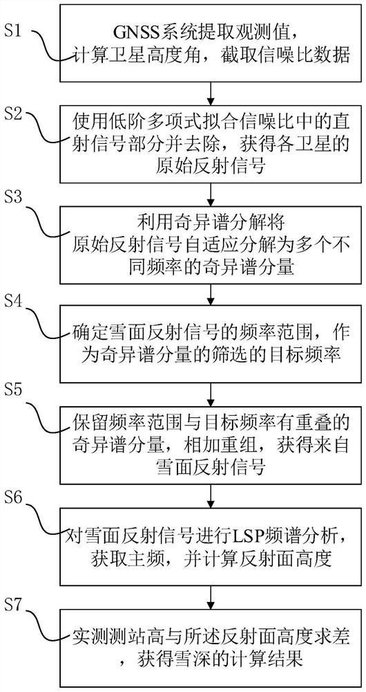
[0029] The present invention will be further described below in conjunction with the accompanying drawings and embodiments. This figure is a simplified schematic diagram, which only schematically illustrates the basic structure of the present invention, so it only shows the structures related to the present invention.
[0030] This example selects the GNSS observation data of the SG27 station (71.323°N, 156.610°W) in a certain plate monitoring plan during the snowfall period of 85 days in the winter of 2019, and intercepts the signal-to-noise ratio data of the 5°-25° satellite elevation angle, and the height of the station It is 3.9m. Taking the real value of the snow depth measured by the local meteorological station, the traditional GNSS reflection signal snow depth extraction method is compared with the results of this method.
[0031] Such as figure 1 As shown, a snow depth extraction method based on multi-system GNSS reflection signals includes the following steps:
[0...
PUM
 Abstract
Description
Claims
Application Information
 - R&D
- Intellectual Property
- Life Sciences
- Materials
- Tech Scout
- Unparalleled Data Quality
- Higher Quality Content
- 60% Fewer Hallucinations
Browse by: Latest US Patents, China's latest patents, Technical Efficacy Thesaurus, Application Domain, Technology Topic, Popular Technical Reports.
© 2025 PatSnap. All rights reserved.Legal|Privacy policy|Modern Slavery Act Transparency Statement|Sitemap|About US| Contact US: help@patsnap.com


