Beidou real-time precision orbit determination method based on satellite perturbation

A technology of precise orbit and determination method, applied in satellite radio beacon positioning systems, instruments, measurement devices, etc., and can solve problems such as limiting the application of real-time user precise positioning

Active Publication Date: 2020-08-04
HARBIN ENG UNIV
View PDF8 Cites 6 Cited by
  • Summary
  • Abstract
  • Description
  • Claims
  • Application Information

AI Technical Summary

Problems solved by technology

[0003] However, most of the current Beidou precision ephemeris is generated based on post-processing, which limits the application of real-time user precise positioning

Method used


Image

  • Beidou real-time precision orbit determination method based on satellite perturbation
  • Beidou real-time precision orbit determination method based on satellite perturbation
  • Beidou real-time precision orbit determination method based on satellite perturbation

Examples


Embodiment

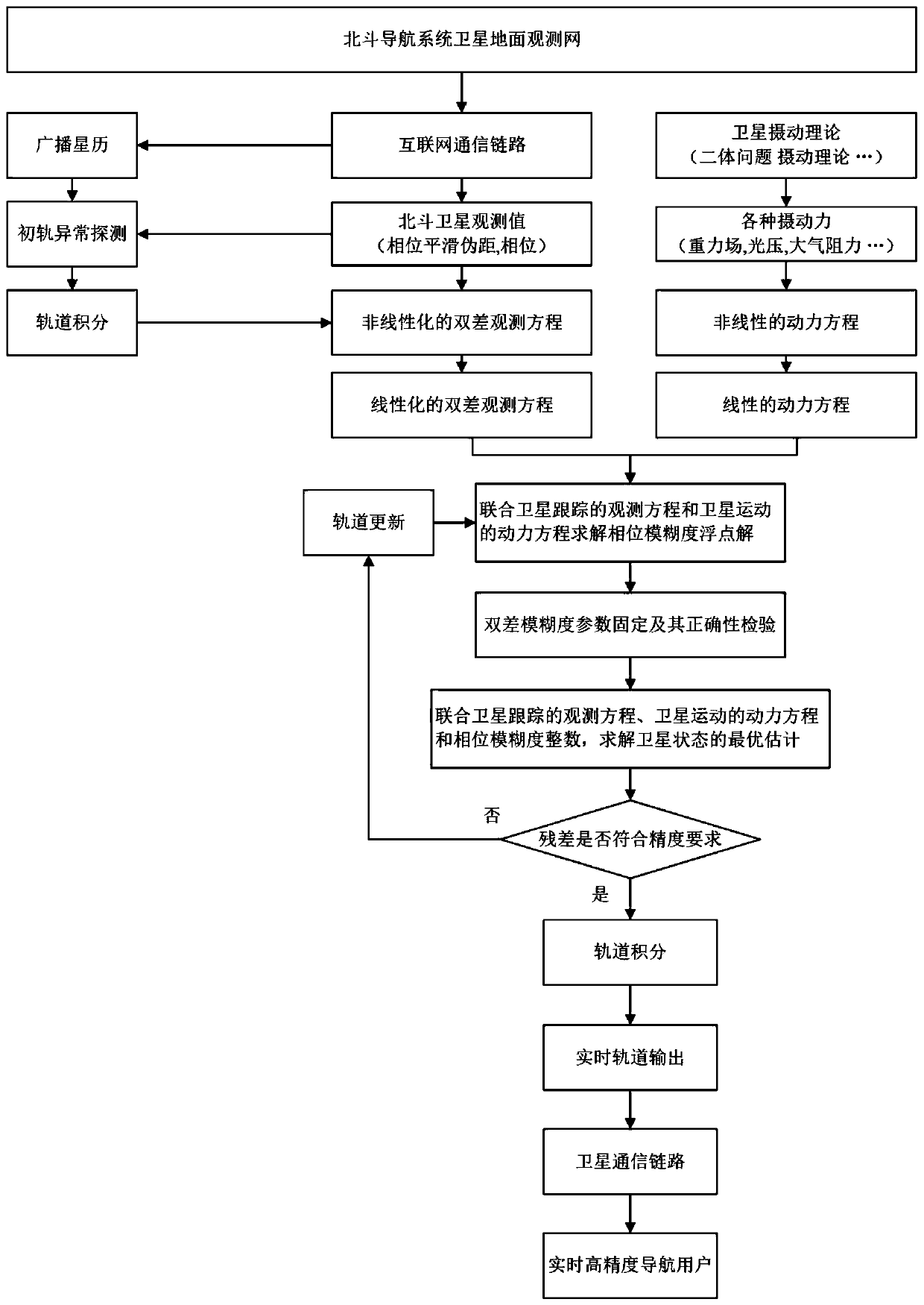
[0061] The present invention is a Beidou real-time precise orbit determination method based on satellite perturbation, and the specific steps include:

[0062] Step 1, the satellite observation information is collected and the user sends a positioning request signal

[0063] Use evenly distributed ground observation stations around the world to collect satellite observation information and navigation information of the Beidou navigation system, and send the information collection results of each station to the data processing center through the Internet communication link, so that the data processing center can be easily accessed and backed up.

[0064] Step 2, construction of satellite observation equation

[0065] The data processing center preprocesses the satellite navigation information and observation information, mainly including the elimination of broadcast ephemeris outliers and smoothing of pseudoranges.

[0066] In the broadcast ephemeris anomaly detection process,...


PUM


Abstract

The invention belongs to the technical field of ship navigation, and particularly relates to a Beidou real-time precision orbit determination method based on satellite perturbation. An observation reference network based on a plurality of Beidou navigation satellite systems is utilized, satellite operation orbit parameters are generated by utilizing satellite observation information according to the dynamic characteristics of satellite operation, and real-time high-precision satellite position information is provided for the user based on an orbit integration method to assist the user to realize real-time precision positioning. The method comprises the steps that a ground observation station collects satellite observation information and navigation information of a Beidou navigation systemand sends the satellite observation information and the navigation information to a data processing center through an internet communication link. The dynamic characteristics of the satellite runningin the outer space are fully utilized, satellite operation orbit parameters are estimated and predicted through ground satellite observation information, real-time high-precision satellite position information is generated through an orbit integration method and broadcasted to the user for correcting satellite orbit errors to assist the user in achieving real-time high-precision positioning in the true sense.

Description

technical field [0001] The invention belongs to the technical field of ship navigation, and specifically relates to an observation reference network based on the Beidou navigation satellite system, according to the dynamic characteristics of satellite operation, and using satellite observation information to generate satellite operating orbit parameters, based on the orbit integration method It provides users with real-time high-precision satellite position information and assists users in realizing real-time precise positioning. The satellite perturbation-based Beidou real-time precise orbit determination method. Background technique [0002] The exploration and development of the ocean has far-reaching significance to my country's national defense construction and development strategy. In order to expand the development and utilization of the marine environment, it is urgent to carry out research on providing high-precision positioning methods for sea navigation, marine su...

Claims


Application Information

Patent Timeline
Patent Type & Authority Applications(China)
IPC IPC(8): G01S19/40G01S19/44G01S19/07
CPCG01S19/40G01S19/44G01S19/07
Inventor 李亮刘媛媛程春王仁龙程建华李慧赵琳丁继成
Owner HARBIN ENG UNIV
Why Eureka
Try Eureka