Single-station landslide deformation monitoring and early warning method based on GNSS environment model

An environmental model and deformation monitoring technology, which is applied to alarms, measuring devices, and radio wave measurement systems, can solve the problems of high early warning costs and low success rates, and achieve the effect of reducing monitoring costs

Active Publication Date: 2020-09-22
NAT TIME SERVICE CENT CHINESE ACAD OF SCI
View PDF7 Cites 2 Cited by
  • Summary
  • Abstract
  • Description
  • Claims
  • Application Information

AI Technical Summary

Problems solved by technology

[0006] Aiming at the problems of high early warning cost and low success rate of existing GNSS landslide deformation monitoring technology, the present invention provides a single-station landslide deformation monitoring and early warning method based on GNSS environmental model

Method used


Image

  • Single-station landslide deformation monitoring and early warning method based on GNSS environment model
  • Single-station landslide deformation monitoring and early warning method based on GNSS environment model
  • Single-station landslide deformation monitoring and early warning method based on GNSS environment model

Examples


Embodiment 1

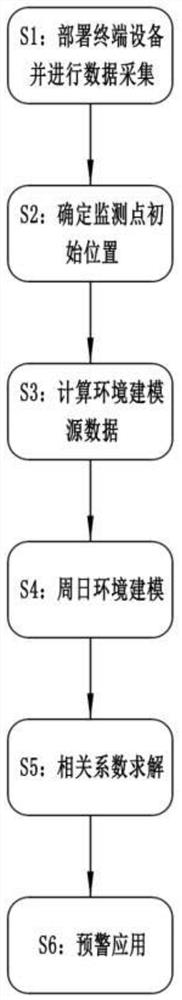
[0038] Embodiment 1: This embodiment designs a single-station landslide deformation monitoring and early warning method based on the GNSS environment model, which is mainly used to propose a new monitoring and early warning method based on consumer-grade single-frequency GNSS. figure 1 The flow chart of the method is described in detail.

[0039] S1: Deploy terminal equipment and collect data

[0040] Deploy the GNSS application terminal on the monitoring point (landslide deformation characteristic point), collect the original observation data of the monitoring point through wireless communication networks such as 4G or 5G after starting up, and the original observation data includes original pseudorange and ephemeris data; Among them, the GNSS application terminal can be selected as consumer-grade single-frequency GNSS, or it can be a professional type with centimeter-level accuracy or a general measurement type with sub-meter-level accuracy. GNSS includes one or more of BDS / ...

Embodiment 2

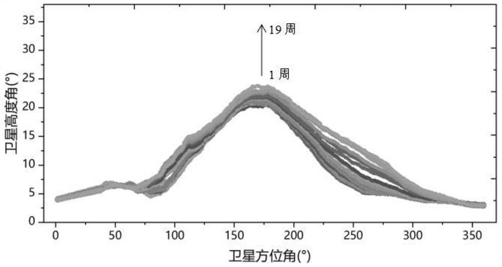
[0062] Embodiment 2: In this embodiment, the method in Embodiment 1 is used for actual measurement, and the data of a certain landslide monitoring point in the creep stage are selected for experimentation. modeling, the result is as figure 2 as shown, figure 2 The direction indicated by the arrow in the figure represents the modeling results of 19 consecutive weeks from the 1st week to the 19th week. It can be seen that with the creep movement of the monitoring point, the satellite elevation angle of the environmental model at the same azimuth gradually increases.

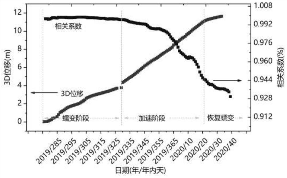
[0063] combine image 3 The three-dimensional position change of the monitoring point and the timing diagram of the correlation coefficient are given, image 3 The middle horizontal axis represents the time axis, the left vertical axis represents the 3D vector displacement, and the right vertical axis represents the correlation coefficient. It can be seen from the displacement sequence that the monitoring poin...


PUM


Abstract

The invention discloses a single-station landslide deformation monitoring and early warning method based on a GNSS environment model. The method comprises the following steps of deploying terminal equipment and performing data acquisition, determining an initial position of a monitoring point, calculating environment modeling source data, performing weekday environment modeling, solving a correlation coefficient and performing early warning application. According to the monitoring and early warning method of the invention, a low-cost consumption-level GNSS positioning terminal is adopted to perform data acquisition and environmental modeling; the landslide acceleration state is subjected to early identification and effective early warning through the change trend of the correlation coefficient of the environment model, so that the monitoring cost is greatly reduced, and a new thought and a new method are provided for GNSS landslide monitoring and early warning.

Description

technical field [0001] The invention belongs to the technical field of monitoring and early warning, and in particular relates to a single-station landslide deformation monitoring and early warning method based on a GNSS environment model. Background technique [0002] my country is one of the most serious landslide disaster countries in the world. According to incomplete statistics from the National Geological Hazards Network, in 2019 alone, there were 6,181 geological disasters across the country, with a direct economic loss of 2.77 billion yuan; 948 geological disasters were successfully predicted, involving more than 20,000 people who may be injured, and direct economic losses of 830 million yuan were avoided. Remarkable results have been achieved in disaster prevention and mitigation. Landslide disaster losses accounted for as high as 61.2% of the total disasters, and the implementation of efficient monitoring and early warning of landslides has important practical sig...

Claims


Application Information

Patent Timeline
Patent Type & Authority Applications(China)
IPC IPC(8): G01S19/14G01S19/33G08B21/10H04L29/08
CPCG01S19/14G01S19/33G08B21/10H04L67/12H04L67/025
Inventor 韩军强涂锐卢晓春张睿范丽红张鹏飞洪菊刘金海王星星
Owner NAT TIME SERVICE CENT CHINESE ACAD OF SCI
Why Eureka
Try Eureka