High-resolution aquifer water storage coefficient inversion method and system based on gravity satellite
A technology of satellite data and gravity, applied in probabilistic CAD, image data processing, structured data retrieval, etc., can solve problems such as difficult large-scale applications, time-consuming and labor-intensive, and achieve the effect of time-consuming and labor-intensive solutions
- Summary
- Abstract
- Description
- Claims
- Application Information
AI Technical Summary
Problems solved by technology
Method used
Image

Examples
Embodiment 1
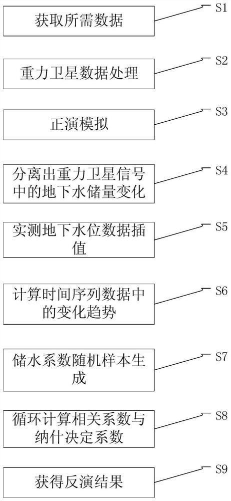
[0052] In a specific embodiment, the method proposed by the present invention can adopt such as figure 1 The process shown to achieve; as figure 1 As shown, in a specific embodiment, the high-resolution aquifer water storage coefficient retrieval method based on gravity satellites may include:
[0053] Step S1: Obtain GRACE / GRACE-FO gravity satellite data, soil water content data, surface water storage data and other non-groundwater component data with grid size and grid range consistent according to the boundary and latitude and longitude information of the preset area;
[0054] In this embodiment, the GRACE / GRACE-FO gravity satellite data is the CSRRL05 Level-February gravity field spherical harmonic data released by the GRACE Scientific Data System (SDS), and the soil water data adopts the Global Land Surface Data Assimilation System (GLDAS ) The monthly soil moisture data set of the common land surface model (CommonLandModel, CLM), the surface water data adopts the "China...
Embodiment 2
[0102] In addition to the implementation in Embodiment 1, the technical solution of the present invention can also be realized by a high-resolution aquifer water storage coefficient inversion system based on gravity satellites. In a preferred embodiment, the system includes:
[0103] The basic data acquisition module is used to acquire gravity satellite data, soil water content data, surface water storage data and other non-groundwater component data based on the preset area;
[0104] The monthly time series module is used to obtain the monthly time series of land water storage changes based on the inversion of the gravity satellite data by performing truncation processing and filtering processing on the gravity satellite data; and the soil water content data, surface water Reserve data and other non-groundwater component data are forward modeled to simulate signal leakage, and the monthly time series of soil water content, surface water storage and other non-groundwater compo...
PUM
 Abstract
Description
Claims
Application Information
 - R&D Engineer
- R&D Manager
- IP Professional
- Industry Leading Data Capabilities
- Powerful AI technology
- Patent DNA Extraction
Browse by: Latest US Patents, China's latest patents, Technical Efficacy Thesaurus, Application Domain, Technology Topic.
© 2024 PatSnap. All rights reserved.Legal|Privacy policy|Modern Slavery Act Transparency Statement|Sitemap