
Graphical display method for marine meteorological safety early warning

A graphic display and safety warning technology, applied in image data processing, structured data retrieval, structured data browsing, etc., can solve the problem of reducing work efficiency and achieve the effect of improving work efficiency

Pending Publication Date: 2020-10-30
广东省气象公共安全技术支持中心
View PDF7 Cites 1 Cited by
  • Summary
  • Abstract
  • Description
  • Claims
  • Application Information

AI Technical Summary

Benefits of technology

This technology helps people who want to see waves at different locations around their world easily with an easy-to-understand display that shows how well they have been doing something about them or what other things may happen near these areas during daylight hours when there's no lighting conditions.

Problems solved by technology

This technical problem addressed by this patented technology relates how monitoring ocean waves can help prevent damage from seismic events such as tsunamis or other impact on structures during drilling activities for oil well exploration purposes.

Method used


Image

  • Graphical display method for marine meteorological safety early warning

Examples


Embodiment

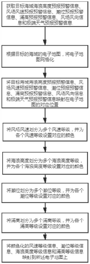
[0049] figure 1 A flow chart of a graphical display method for marine meteorological safety early warning according to an embodiment of the present invention is shown.

[0050] A graphical display method for marine meteorological safety early warning, comprising:

[0051] Obtain the wave height forecast and early warning information of the target sea area and the wind field wind speed forecast and early warning information;

[0052] gridding the electronic map according to the electronic map of the sea area of ​​the target;

[0053] Mapping the wave height forecast and early warning information and the wind field wind speed forecast and early warning information of the target sea area on the corresponding position of the electronic map;

[0054] Divide the wind speed of the wind field into multiple wind speed levels, and set corresponding colors for each wind speed level;

[0055] Divide the wave height into multiple wave height levels, and set corresponding colors for each...


PUM


Abstract

The invention discloses a graphical display method for marine meteorological safety early warning. The method includes the steps: obtaining sea wave height forecasting and early warning information and wind field wind speed forecasting and early warning information of a target sea area; according to an electronic map of the target sea area, mapping the sea wave height forecasting and early warninginformation and the wind field wind speed forecasting and early warning information of the target sea area to corresponding positions of the electronic map; dividing the wind field wind speed into aplurality of wind speed grades, and setting corresponding colors for the wind speed grades; and mapping the colored wind speed grade information to the electronic map. According to the invention, thewind speed of the wind field is colored, so that a worker can determine the wind speed of the wind field everywhere in the target sea area more visually; and the sea wave height information and the wind field wind speed information of the target sea area are mapped on the electronic map, so that the worker can determine the specific sea wave height information and the wind field wind speed information, and can check the accurate information of a certain position on the map more conveniently and quickly, and the working efficiency is improved.

Description


Claims


Application Information

Patent Timeline
Owner 广东省气象公共安全技术支持中心
Learn More