
A Deformation Monitoring Method of Collapse and Landslide Disaster Body

A deformation monitoring and disaster body technology, applied in forecasting, instrumentation, data processing applications, etc., can solve the problems of high cost, inability to measure the specific changes of the collapsed body in real time, not suitable for 24-hour real-time dynamic monitoring, etc. sexual effect

Active Publication Date: 2021-08-03
CENT FOR HYDROGEOLOGY & ENVIRONMENTAL GEOLOGY CGS
View PDF9 Cites 0 Cited by
  • Summary
  • Abstract
  • Description
  • Claims
  • Application Information

AI Technical Summary

Problems solved by technology

The network and point layout work is complicated and cumbersome, requiring a lot of working time, manpower and material resources, and the well-arranged control points and monitoring points are easily affected and damaged by the outside world, which cannot meet the current monitoring technical requirements
[0009] In addition, the remote sensing (RS) method and close-range photography method, which have emerged in recent years, use earth satellites or aircraft to periodically photograph the deformation of landslides, which are suitable for large-scale and regional landslide monitoring. Although the accuracy is high, the cost It is also relatively high, not suitable for 24-hour real-time dynamic monitoring, and can not measure the specific changes of landslides in real time, and has a certain hysteresis
[0010] None of the above monitoring methods can meet the monitoring of landslides that require higher and higher safety requirements.

Method used


Image

  • A Deformation Monitoring Method of Collapse and Landslide Disaster Body
  • A Deformation Monitoring Method of Collapse and Landslide Disaster Body
  • A Deformation Monitoring Method of Collapse and Landslide Disaster Body

Examples


Embodiment Construction

[0067] The technical problems, technical solutions and advantages of the present invention will be explained in detail below by referring to exemplary embodiments and in conjunction with the accompanying drawings. The exemplary embodiments described below are only for explaining the present invention, but not construed as limiting the present invention. Those skilled in the art can understand that, unless otherwise defined, all terms (including technical and scientific terms) used herein have the same meaning as commonly understood by one of ordinary skill in the art to which this invention belongs. It should also be understood that terms such as those defined in commonly used dictionaries should be understood to have meanings consistent with their meaning in the context of the prior art and will not be used in an idealized or overly formal sense unless defined herein to explain.

[0068] The embodiment of the present invention provides a deformation monitoring method of a co...


PUM


Abstract

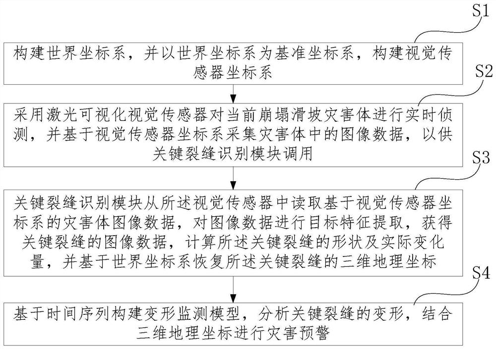
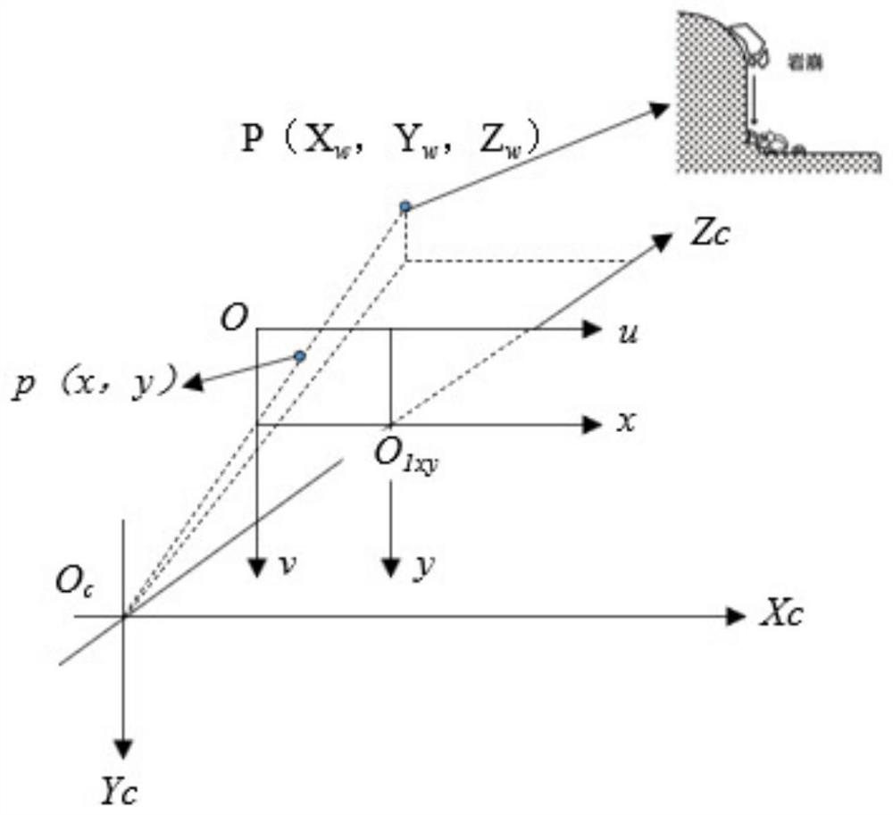
The invention provides a deformation monitoring method of a landslide disaster body, belonging to the field of geological disaster monitoring. The deformation monitoring method of the collapse and landslide disaster body constructs a world coordinate system and a visual sensor coordinate system, and uses a laser visualization sensor to detect the disaster body in real time, collects image data based on the coordinate system, and the key crack identification module reads the image data Finally, extract the target features, obtain key fracture image data, calculate the shape and actual change of the key crack, and restore the three-dimensional geographic coordinates of the key crack based on the world coordinate system; build a deformation monitoring model based on time series, and analyze the key crack The deformation, combined with three-dimensional geographic coordinates for disaster warning. The present invention judges the deformation trend of the collapse and landslide disaster body and warns in time within an effective time, improves the real-time performance, accuracy and stability of the deformation monitoring of the collapse and landslide disaster body, has small amount of data processing calculation, strong adaptability, and saves Monitor resources.

Description

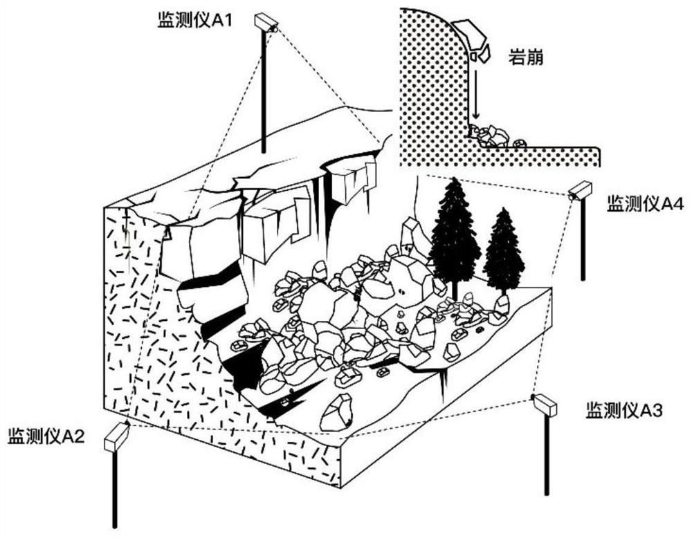
technical field [0001] The invention belongs to the field of geological disaster monitoring, and in particular relates to a deformation monitoring method of a landslide disaster body. Background technique [0002] There are hidden dangers of landslides and other disasters in dangerous rock areas. When danger occurs, buildings and even entire residential areas will be destroyed, and roads and railways will be buried. The loss caused by dangerous rocks is not only the direct loss of building destruction, but also often interrupts traffic, brings heavy losses to transportation, and also brings great danger to people's lives, property and safety. Landslide disaster monitoring includes surface deformation monitoring, deep displacement monitoring, mechanical parameter monitoring, environmental impact factors (surface water, groundwater, rainfall, etc.) monitoring and macroscopic geological phenomenon monitoring. [0003] In the absence of effective methods to monitor deep large d...

Claims


Application Information

Patent Timeline
Patent Type & Authority Patents(China)
IPC IPC(8): G06K9/00G06K9/34G06K9/46G08B21/10G06Q10/04G06Q50/26
CPCG08B21/10G06Q10/04G06Q50/265G06V20/52G06V10/267G06V10/44
Inventor 王晨辉程玉华赵贻玖曹修定朱赛楠郭伟孟庆佳李鹏杨凯吴悦
Owner CENT FOR HYDROGEOLOGY & ENVIRONMENTAL GEOLOGY CGS
Learn More