A method and system for oil and gas pipeline routing planning

An oil and gas pipeline and routing technology, applied in the field of efficient planning of oil and gas pipeline routing, can solve the problems that hinder the sustainable development of oil and gas enterprises, the large amount of routing planning engineering, and the long cycle of scheme formulation, so as to avoid redundant calculation and solve the problem of data volume Effects of large, high-quality designs

Inactive Publication Date: 2021-10-08
NORTHEAST GASOLINEEUM UNIV
View PDF16 Cites 0 Cited by
  • Summary
  • Abstract
  • Description
  • Claims
  • Application Information

AI Technical Summary

Problems solved by technology

Due to the strong randomness of 3D terrain, the large scale of digital terrain data, and the need for pipeline construction to meet various design specifications, most of the current pipeline routing planning schemes are obtained by manual decision-making. However, due to the uncertainty of manual experience, it is easy to These problems have seriously hindered the sustainable economic development of oil and gas companies, and it is urgent to solve them by innovating related technologies

Method used


Image

  • A method and system for oil and gas pipeline routing planning
  • A method and system for oil and gas pipeline routing planning
  • A method and system for oil and gas pipeline routing planning

Examples


Embodiment 1

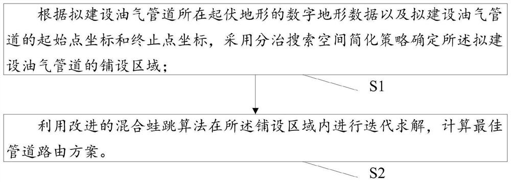
[0026] This embodiment is used to provide a method for planning oil and gas pipeline routing, such as figure 1 As shown, the planning method includes the following steps:

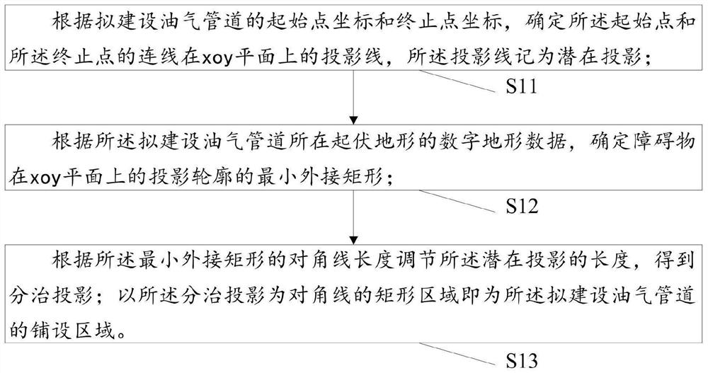
[0027] S1: According to the digital terrain data of the undulating terrain where the oil and gas pipeline is to be built, and the coordinates of the starting point and the end point of the oil and gas pipeline to be built, the division and conquer search space simplification strategy is used to determine the laying area of ​​the oil and gas pipeline to be built;

[0028] In the prior art, when determining the laying area of ​​the oil and gas pipeline to be built, the determined laying area is very large, and the digital terrain data corresponding to the laying area is very large, so for the huge amount of digital terrain data corresponding to the laying area Problem, this embodiment proposes a divide-and-conquer search space simplification strategy to effectively compress the data scale of the digital terra...

Embodiment 2

[0099] This embodiment is used to provide an oil and gas pipeline route planning system, such as Figure 7 As shown, the planning system includes:

[0100] The laying area determination module M1 is used to determine the laying of the proposed oil and gas pipeline by using a divide-and-conquer search space simplification strategy based on the digital terrain data of the undulating terrain where the proposed oil and gas pipeline is located and the coordinates of the starting point and the ending point of the proposed oil and gas pipeline area;

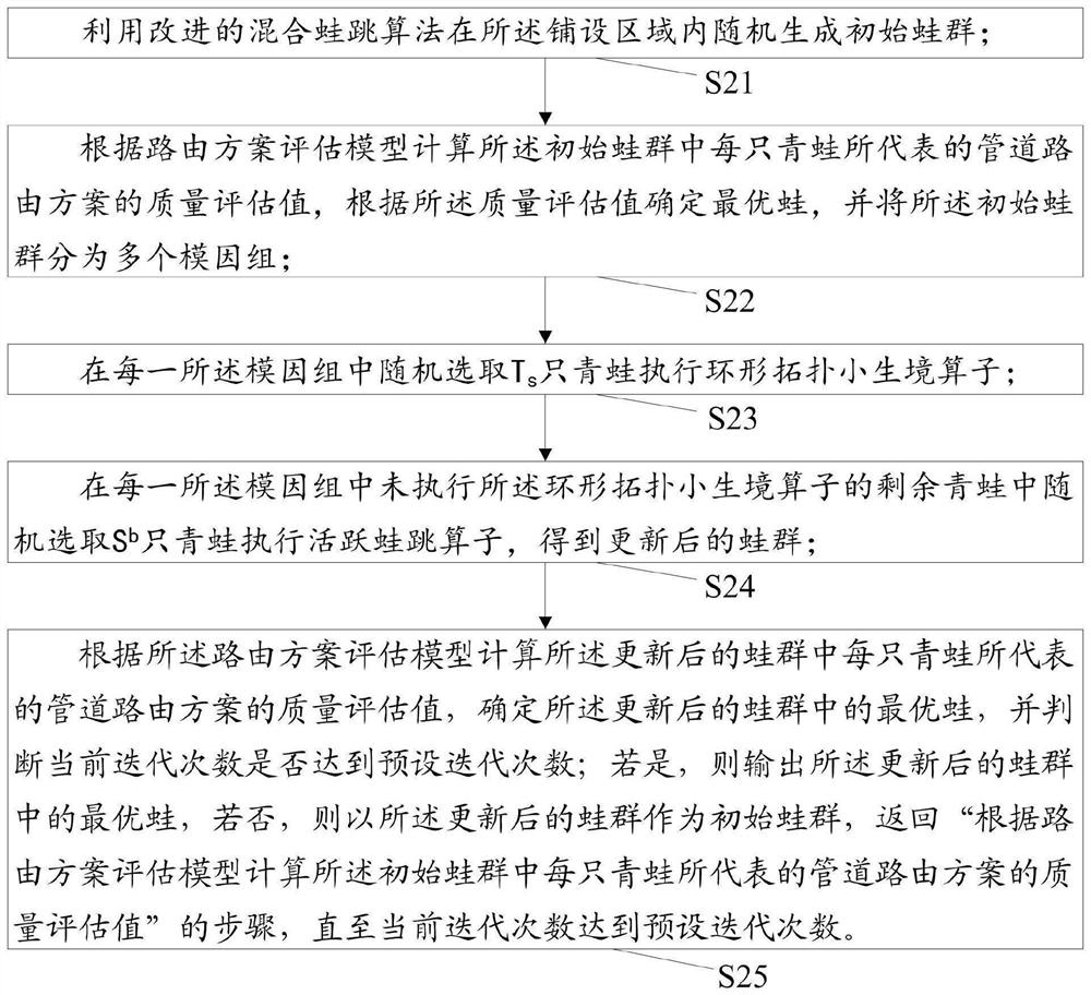
[0101] The optimal pipeline routing scheme calculation module M2 is used to iteratively solve in the laying area by using the improved hybrid leapfrog algorithm to calculate the optimal pipeline routing scheme.


PUM


Abstract

The invention relates to a route planning method and system for oil and gas pipelines. First, according to the digital terrain data of the undulating terrain where the oil and gas pipelines are to be built, and the coordinates of the starting point and the end point of the oil and gas pipelines to be built, a simplified strategy of dividing and conquering the search space is adopted to determine the planned construction. The laying area of ​​oil and gas pipelines can effectively compress the data scale of the digital terrain in the laying area, so that the pipeline routing planning is only carried out in the divided and conquered terrain corresponding to the small-scale laying area, which effectively avoids redundant calculations and solves the problem of the amount of digital terrain data. It is a huge, complex and high calculation problem of oil and gas pipeline routing planning. Then, the improved hybrid frog leaping algorithm is used to iteratively solve the problem in the laying area, and the optimal pipeline routing scheme is calculated, thereby avoiding the problems of large engineering volume, high construction cost, and long scheme formulation period caused by the uncertainty of artificial experience. , to achieve efficient and high-quality design of oil and gas pipeline routing schemes.

Description

technical field [0001] The invention relates to the technical field of oil and gas pipeline routing planning, in particular to an efficient planning method and system for oil and gas pipeline routing under digital terrain. Background technique [0002] In the process of laying oil and gas pipelines under undulating terrain conditions, it is necessary to consider the influence of three-dimensional terrain on pipeline routing. Pipeline routing refers to the path between the starting point of the pipeline and the destination, that is, the direction of the pipeline. Whether it is for the builders of oil and gas fields in Xinjiang, Changqing, Sichuan and other places, or the managers of long-distance oil and gas pipelines such as the China-Russia-Moscow-Dalian Line, it is extremely difficult to plan and design pipeline routes under undulating terrain. Due to the strong randomness of 3D terrain, the large scale of digital terrain data, and the need for pipeline construction to mee...

Claims


Application Information

Patent Timeline
Patent Type & Authority Patents(China)
IPC IPC(8): G06F30/18G06Q10/04G06N3/00G06T17/05
CPCG06N3/006G06Q10/047G06T17/05G06F30/18G06F2113/14
Inventor 陈双庆刘扬官兵王志华赵健卜凡熙
Owner NORTHEAST GASOLINEEUM UNIV
Why Eureka
Try Eureka