

Public facilities management system and method based on two-dimensional code and geospatial coordinates
A public facility and geospatial technology, applied in the field of public facility governance system based on two-dimensional codes and geospatial coordinates, can solve problems such as the lack of detailed elaboration of the division method of public facility ownership and unreasonable allocation of public facilities
- Summary
- Abstract
- Description
- Claims
- Application Information
AI Technical Summary
Problems solved by technology
Method used
Image

Examples
Embodiment 1
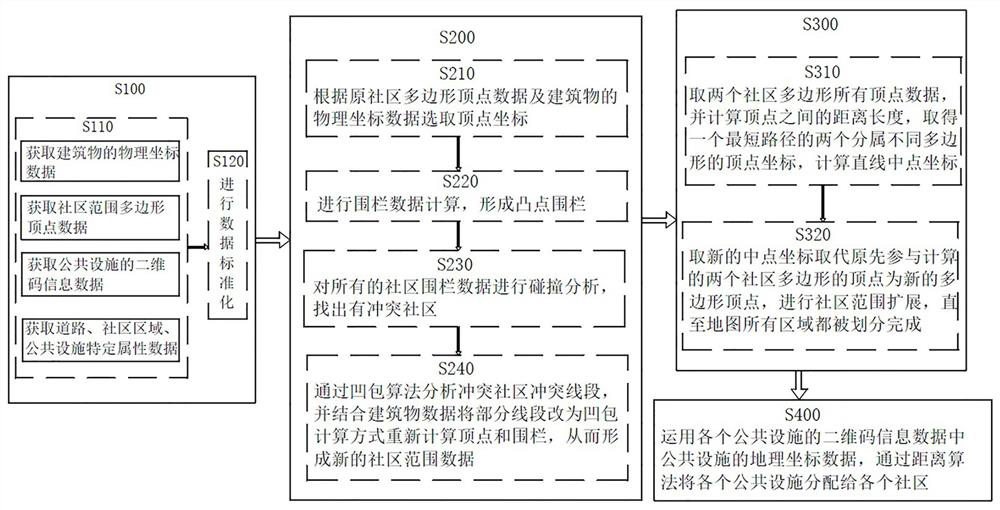
[0057] Such as figure 1 As shown, the public facilities governance method based on two-dimensional codes and geographic space coordinates includes the following steps:
[0058] S100. Obtain the physical coordinate data of each building in the city, the polygon vertex data of each community, and the two-dimensional code information data of each public facility, and standardize all the initial data. The physical coordinate data of the building can be converted into geographical coordinates, but the conversion Later, the length, width and height attributes will be attached.
[0059] Step S100 further includes:
[0060] S110. Obtain the physical coordinate data of each building in the city, the polygon vertex data of each community, and the two-dimensional code information data of each public facility, and also obtain the specific attribute data of roads, special areas, and public facilities. These specific attributes are used in determining the attribution relationship The prop...
Embodiment 2
[0090] The present invention also provides a public facility management system based on two-dimensional codes and geographic space coordinates, including a public facility data center server and several intelligent mobile terminals.
[0091] The public facility data center server provides a system interface, which can query the community to which the public facility belongs. Community grid staff can log in to the system and query the community and public facilities in the community on the map interface. If there is a situation that does not meet the actual management, the administrator can manually adjust it through the background management module.
[0092] The public facility data center server communicates with each smart mobile terminal through the network.
[0093] The system can implement the corresponding methods in the foregoing method embodiments, and its specific implementation process can refer to the foregoing method embodiments, and will not be repeated here.
[...
PUM
 Abstract
Description
Claims
Application Information