An edge optimization method for building semantic segmentation in remote sensing images based on multi-task cnn+gcn

A semantic segmentation and remote sensing image technology, applied in remote sensing image building semantic segmentation edge optimization, surveying and mapping science, can solve the problem of difficult to extract fine location information of each pixel, without considering CNN pooling scale, translation and rotation invariant convolution Gradually abstract features and other issues to achieve the effect of improving accuracy, application value, and strong feasibility

Active Publication Date: 2022-02-11
CHINA UNIV OF GEOSCIENCES (WUHAN)
View PDF5 Cites 0 Cited by
  • Summary
  • Abstract
  • Description
  • Claims
  • Application Information

AI Technical Summary

Problems solved by technology

[0003] The existing CNN-based edge optimization techniques for semantic segmentation of buildings in remote sensing images can be divided into edge optimization methods based on traditional structural modeling, edge optimization methods based on CNN feature enhancement, edge optimization methods based on edge information guidance, and graph information-based edge optimization methods. An integrated edge optimization method, but the above methods do not consider the characteristics of CNN due to pooling scale, translation, rotation invariance and the characteristics of convolution gradually abstracting features, it is difficult to extract the spatially fine position information of each pixel, how to use Non-CNN way to accurately perceive the precise location of each pixel in space to optimize the results of CNN-based semantic segmentation of remote sensing image buildings There is currently no clear solution

Method used


Image

  • An edge optimization method for building semantic segmentation in remote sensing images based on multi-task cnn+gcn
  • An edge optimization method for building semantic segmentation in remote sensing images based on multi-task cnn+gcn
  • An edge optimization method for building semantic segmentation in remote sensing images based on multi-task cnn+gcn

Examples


Embodiment Construction

[0046] In order to have a clearer understanding of the technical features, purposes and effects of the present invention, the specific implementation manners of the present invention will now be described in detail with reference to the accompanying drawings.

[0047] The embodiment of the present invention provides an edge optimization method for semantic segmentation of remote sensing image buildings based on multi-task CNN+GCN.

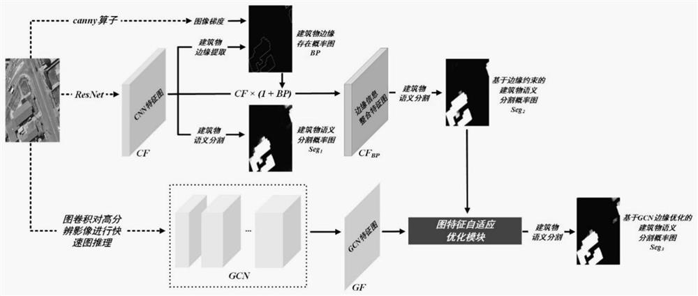
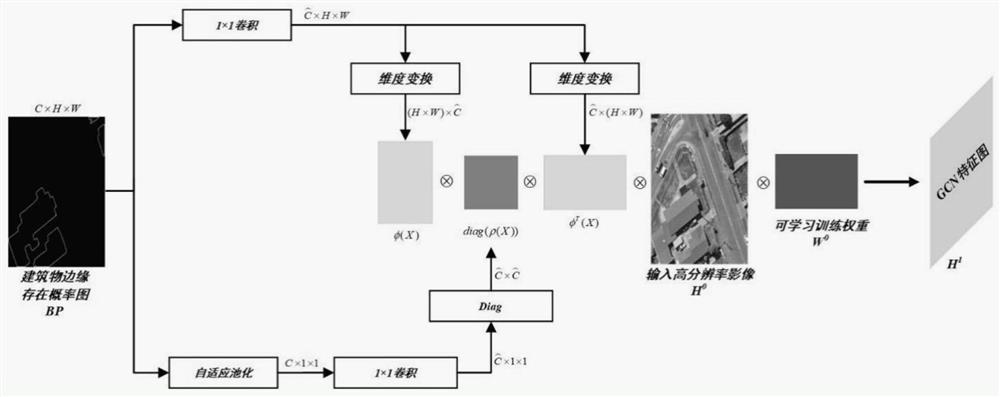
[0048] Please refer to figure 1 , figure 1 It is a schematic structural diagram of a multi-task CNN+GCN semantic segmentation model of a remote sensing image building semantic segmentation edge optimization method in an embodiment of the present invention, and the specific steps include:

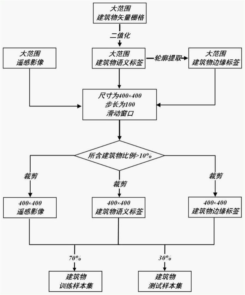
[0049] S1. Constructing a remote sensing image building sample set, please refer to figure 2 , constructing a remote sensing image building sample set specifically includes the following steps:

[0050] S11, converting the original building vector raster into...


PUM


Abstract

The invention provides a multi-task CNN+GCN based remote sensing image building semantic segmentation edge optimization method, using CNN to extract high-level semantic features of buildings from remote sensing images, and using GCN to quickly perform graph reasoning on high-resolution original images ; Then use several times of upsampling, horizontal connection and convolution operations to remap the deep features from CNN with lower resolution to the original image, and use this to extract building edges and first semantic segmentation of buildings; combine deep features with edge The extraction results are integrated to constrain the edges of the initial building semantic segmentation results; finally, the graph feature adaptive optimization module is used to promote the GCN feature to effectively optimize the constrained building semantic segmentation results, and output the building semantic segmentation with excellent edge performance result. The beneficial effects of the invention are: adaptively optimizing the edge details of the semantic segmentation results of buildings in remote sensing images based on CNN, and improving the accuracy and application value of the results of automatic mapping of buildings.

Description

technical field [0001] The invention relates to the field of surveying and mapping science and technology, in particular to a multi-task CNN+GCN semantic segmentation model for edge optimization of remote sensing image building semantic segmentation, and in particular to a remote sensing image building semantic segmentation based on multi-task CNN+GCN Edge optimization method. Background technique [0002] Accurate building vector outline information obtained from high-resolution remote sensing images can provide important basis for many application fields such as urban planning, land survey, illegal building detection, and military reconnaissance. Due to the high cost of human-based visual interpretation and labeling of high-resolution remote sensing images, the semantic segmentation method based on CNN is used to intelligently and quickly extract remote sensing image buildings, and contour extraction and regularization are used. Generating building vector data is a more e...

Claims


Application Information

Patent Timeline
Patent Type & Authority Patents(China)
IPC IPC(8): G06V20/00G06V10/26G06V10/44G06N3/04
CPCG06N3/045
Inventor 刘修国邓睿哲陈奇张丛珊
Owner CHINA UNIV OF GEOSCIENCES (WUHAN)
Why Eureka
Try Eureka