Construction site panoramic management and control display method and system based on Beidou positioning

A construction site and Beidou positioning technology, applied in satellite radio beacon positioning system, radio wave measurement system, measurement device, etc., can solve problems such as difficulty in realizing panoramic control of construction site, failure to display historical information, and difficulty in data fusion

Pending Publication Date: 2021-11-16
NINGBO JIUZONG INTELLIGENT TECH
View PDF0 Cites 0 Cited by
  • Summary
  • Abstract
  • Description
  • Claims
  • Application Information

AI Technical Summary

Problems solved by technology

[0002] In recent years, with the large-scale application of the smart construction site platform in the construction site, the data collected on the construction site include Beidou positioning data and video, micro-meteorology, BIM, 3D oblique photography models, etc., which have the characteristics of various types and large data volumes. It is

Method used


Image

  • Construction site panoramic management and control display method and system based on Beidou positioning
  • Construction site panoramic management and control display method and system based on Beidou positioning
  • Construction site panoramic management and control display method and system based on Beidou positioning

Examples


Example Embodiment

[0029] Example 1

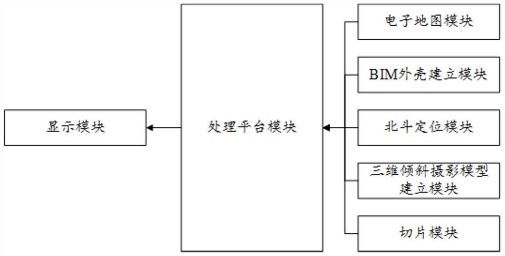
[0030] combine figure 1 As shown, this embodiment provides a method for panoramic control and display of a construction site based on Beidou positioning, which includes the following steps:

[0031] Step S1, establish and display the electronic map P of the construction site, P={P i (x i the y i z i )|i∈N +};

[0032] Step S2, establishing the BIM shell of the expected building and displaying it after coordinate alignment with the electronic map P;

[0033] Step S3, collect the 3D oblique photographic model of each construction period node according to the progress of the construction period and align it to the electronic map P for display;

[0034] Step S4, establishing a two-dimensional orthophoto model of the construction site based on the three-dimensional oblique photographic model, and aligning it to the electronic map P for display;

[0035] Step S5, collect the coordinates of all on-site personnel on the construction site in real time and m...

Example Embodiment

[0052] Example 2

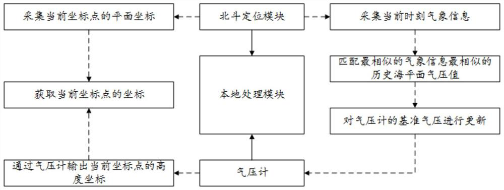
[0053] In view of the fact that the Beidou positioning and positioning system has high positioning accuracy for plane coordinates and poor positioning for altitude coordinates, this embodiment provides a high-precision positioning method based on Beidou positioning and barometer, which can use Beidou The plane coordinates obtained by the positioning module and the altitude obtained by the barometer are used as the measurement coordinates of the coordinate points. Of course, it can be understood that when the electronic map at the electronic map module is constructed, the altitude coordinates of any point are represented by altitude.

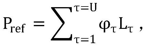
[0054] combine figure 2 As shown, this embodiment provides a high-precision positioning method based on Beidou positioning and barometer, which has the following steps:

[0055] Step S1, obtain the plane coordinates (x, y) of the current coordinate point based on the Beidou positioning module;

[0056] Step S2, obtaining th...


PUM


Abstract

The invention relates to the technical field of construction site data management, and relates to a construction site panoramic control display method and system based on Beidou positioning. The method comprises the following steps: S1, establishing and displaying an electronic map of a construction site; S2, establishing a BIM shell of an expected building, performing coordinate alignment on the BIM shell and the electronic map, and displaying the BIM shell; S3, collecting the three-dimensional oblique photography model of each construction period node according to the construction period process, aligning the three-dimensional oblique photography model to the electronic map and then displaying the three-dimensional oblique photography model; S4, establishing a two-dimensional orthoimage model of the construction site based on the three-dimensional oblique photography model, aligning the two-dimensional orthoimage model to the electronic map, and displaying the two-dimensional orthoimage model; S5, collecting coordinates of all field personnel in the construction field in real time, marking the coordinates in the two-dimensional orthoimage model, and displaying the coordinates; and S6, collecting coordinates of construction equipment on a construction site in real time, marking the coordinates in the two-dimensional orthoimage model, and then displaying the coordinates. The system is used for implementing the method. According to the invention, the field data can be well fused and displayed.

Description

technical field [0001] The invention relates to the technical field of construction site data management, in particular to a method and system for panoramic control and display of a construction site based on Beidou positioning. Background technique [0002] In recent years, with the large-scale application of the smart construction site platform in the construction site, the data collected on the construction site include Beidou positioning data and video, micro-meteorology, BIM, 3D oblique photography models, etc., which have the characteristics of various types and large data volumes. It is difficult to integrate all kinds of data, so the current smart construction site platform simply stacks and displays various types of data. The depth of data fusion is not deep, and historical information cannot be displayed. It is difficult to realize the panoramic control of the construction site because of site situation information such as materials. Contents of the invention ...

Claims


Application Information

Patent Timeline
IPC IPC(8): G01C11/00G01S19/14G01S19/42
CPCG01C11/00G01S19/14G01S19/42
Inventor 郑清秋王杰常业图肖绎霖许华锋
Owner NINGBO JIUZONG INTELLIGENT TECH
Why Eureka
Try Eureka