A marine engineering water area surveying and mapping device

A technology for surveying and mapping devices and marine engineering, which is applied in surveying devices, surveying and mapping and navigation, and open-air water source surveying, etc., can solve problems such as hidden safety hazards, waste of manpower, inaccurate surveying and mapping, and achieve stable location, reduced investment, and stable surveying and mapping convenience. Effect

Active Publication Date: 2022-04-26
山东省地质矿产勘查开发局第四地质大队
View PDF5 Cites 1 Cited by
  • Summary
  • Abstract
  • Description
  • Claims
  • Application Information

AI Technical Summary

Problems solved by technology

[0003] In the process of marine engineering construction, surveying instruments are usually used to survey and map the water surface topography at sea level. During surveying and mapping, most of the surveying instruments float on the horizontal surface. However, in actual measurement, there is usually wind above the sea surface. If it is different, the surveying instrument will be blown back and forth to different positions, and the surveying instrument fluttering back and forth will lead to inaccurate surveying and mapping. In order to ensure the accuracy of surveying and mapping of the surveying instrument, the staff needs to frequently manually control the position of the surveying instrument, which wastes manpower and also exists Large potential safety hazards have brought inconvenience to the surveying and mapping work of marine engineering

Method used


Image

  • A marine engineering water area surveying and mapping device
  • A marine engineering water area surveying and mapping device
  • A marine engineering water area surveying and mapping device

Examples


Embodiment

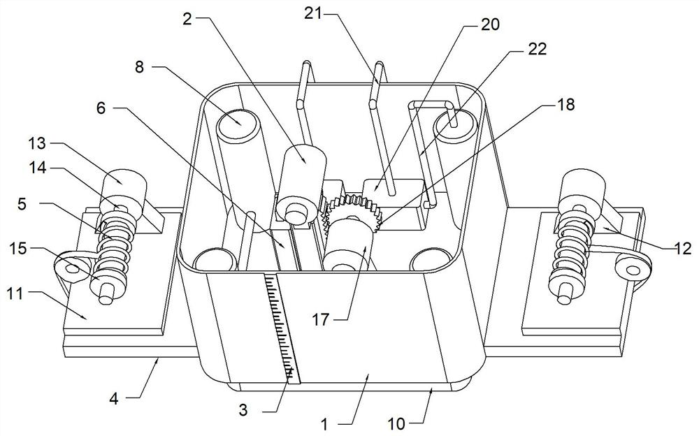
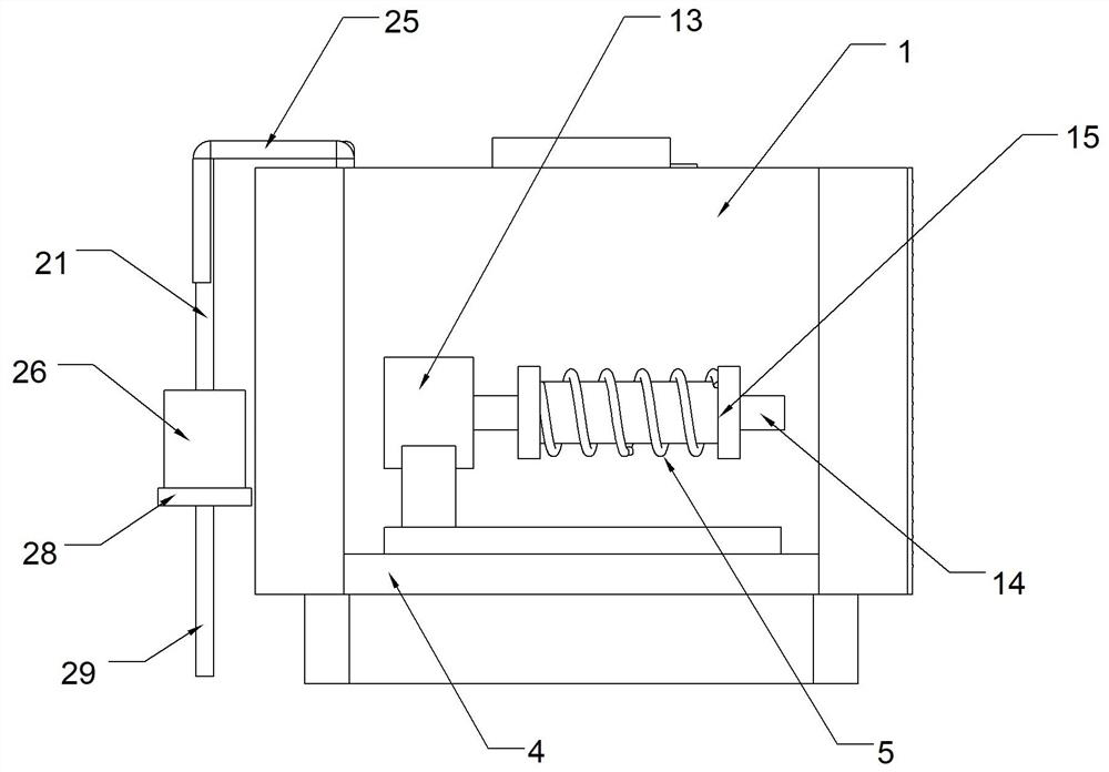
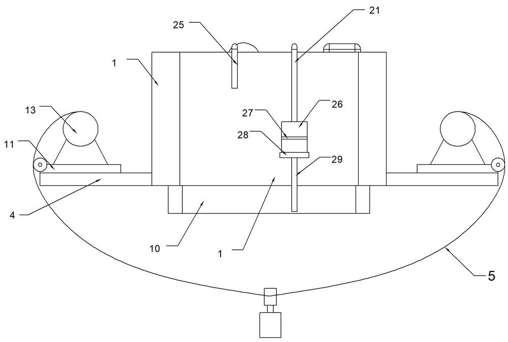
[0027] Example: such as Figure 1-5 As shown, a marine engineering water area surveying and mapping device includes a measuring box 1 and a surveying instrument 2, the outer wall of the measuring box 1 is fixedly connected with a scale 3 for indicating the water level, and both sides of the measuring box 1 are fixedly connected with a first Floating plate 4, the first floating plate 4 is provided with a rewinding device, the rewinding device is connected with a rewinding guide rope 5, and the guide rope 5 is provided with a lead fish for keeping the equipment stable;

[0028] The measuring box 1 is fixedly connected with a guide rail 6, the bottom of the surveying instrument 2 is fixedly connected with a moving seat 7, and the moving seat 7 is slidably connected on the guide rail 6, and the bottom of the measuring box 1 is connected with a moving seat for driving the moving seat. 7 drive device for moving up and down.

[0029] The bottom of the measurement box 1 is fixedly co...


PUM


Abstract

The invention discloses a marine engineering water area surveying and mapping device, which comprises a measuring box and a surveying instrument. A scale for indicating the water level is fixedly connected to the front side wall of the measuring box, and first floating plates are fixedly connected to both sides of the measuring box. , the first floating plate is provided with a winding device for winding the guide rope; the bottom of the measurement box is fixedly connected with a vertically arranged guide rail, and the bottom of the surveying instrument is fixedly connected with a mobile seat. The present invention can ensure the stability of the measuring box and reduce the input of manpower through the cooperation among the measuring box, the surveying instrument, the scale, the guide rope, the winding device, the guide rail, the moving seat and the driving device, and the driving device can work easily. Lift or lower the surveying instrument from the measurement box to realize the automatic storage of the surveying instrument and provide convenience for the surveying and mapping of marine engineering.

Description

technical field [0001] The invention relates to the technical field of surveying and mapping devices, in particular to a marine engineering water area surveying and mapping device. Background technique [0002] Ocean engineering refers to new construction, reconstruction, and expansion projects for the purpose of developing, utilizing, protecting, and restoring marine resources, and the main body of the project is located on the seaward side of the coastline. It is generally believed that the main content of ocean engineering can be divided into resource development technology and equipment facilities Two parts of technology, specifically including: sea reclamation, offshore dam engineering, artificial islands, offshore and submarine material storage facilities, sea-crossing bridges, submarine tunnel engineering, submarine pipeline engineering, etc. [0003] In the process of marine engineering construction, surveying instruments are usually used to survey and map the water ...

Claims


Application Information

Patent Timeline
Patent Type & Authority Patents(China)
IPC IPC(8): G01C7/02G01C13/00G01F23/04B65H75/38B65H75/44
CPCG01C7/02G01C13/00G01F23/04B65H75/38B65H75/4486
Inventor 李云涛曹宾聂金凤
Owner 山东省地质矿产勘查开发局第四地质大队
Why Eureka
Try Eureka