Warning polygons for weather from vehicle sensor data

a technology of vehicle sensor data and warning polygons, which is applied in the direction of process and machine control, instruments, navigation instruments, etc., can solve the problems of difficult detection of geographic areas affected by weather conditions, difficult fog and rain from vehicle sensor data, and dangerous conditions for drivers

Active Publication Date: 2020-12-08
HERE GLOBAL BV
View PDF15 Cites 1 Cited by
  • Summary
  • Abstract
  • Description
  • Claims
  • Application Information

AI Technical Summary

Problems solved by technology

These weather conditions can be hazardous to drivers.
The problem of creating area events to represent these weather events including fog and rain from vehicle sensor data is challenging due to several reasons.
Fewer data points means that the geographic area affected by the weather condition is harder to detect.
In addition, analyzing data for all geographic regions is a computationally burdensome task.
However, the vehicle navigation system has limited computing power.
Finally, there are latencies in the delivery channel that delivers the warnings to the vehicles that may be further slowed by complex calculations.
When the headlights are used, the time of day may limit the associated.
If the threshold confidence level is too high, significant weather events are not detected.
Additionally, the illustrations are merely representational and may not be drawn to scale.

Method used


Image

  • Warning polygons for weather from vehicle sensor data
  • Warning polygons for weather from vehicle sensor data
  • Warning polygons for weather from vehicle sensor data

Examples


embodiment 1

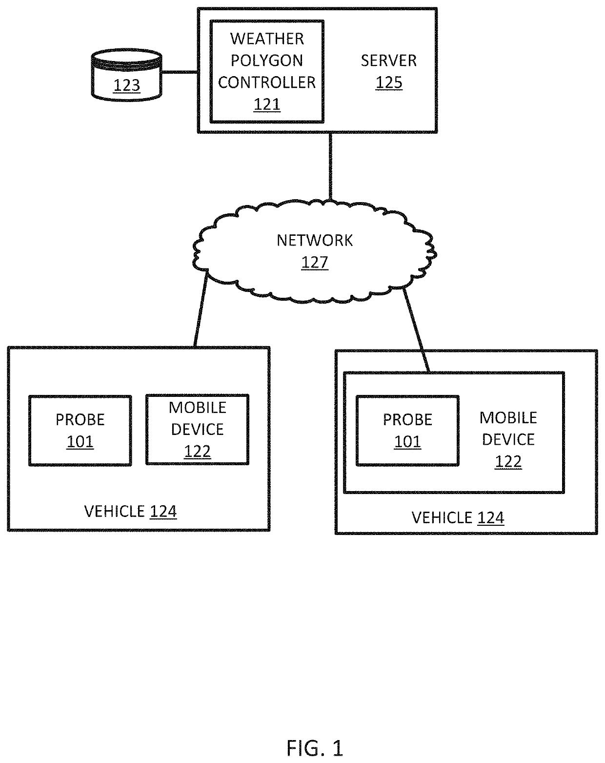
[0147]A method for generating warning polygons for weather events in a geographic region, the method comprising:

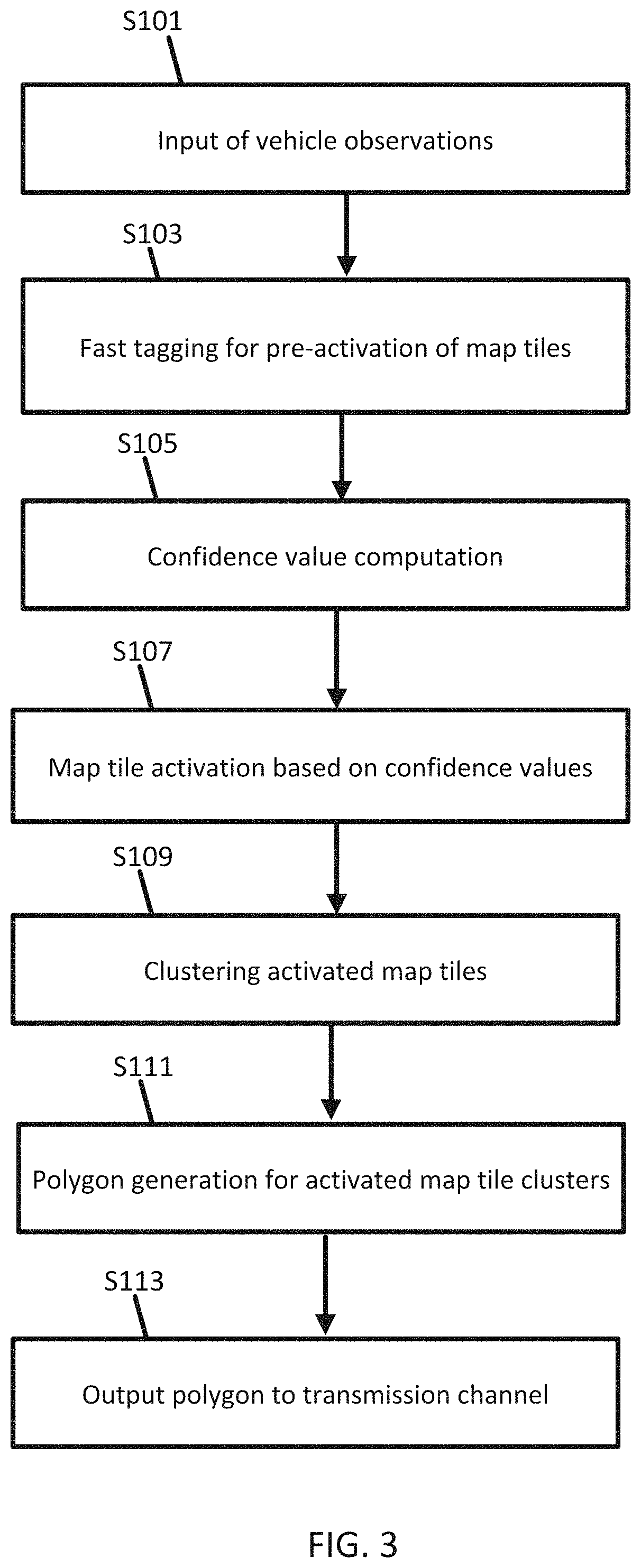
[0148]receiving measurement data from one or more sensors associated with the geographic region;

[0149]identifying at least one location from the measurement data;

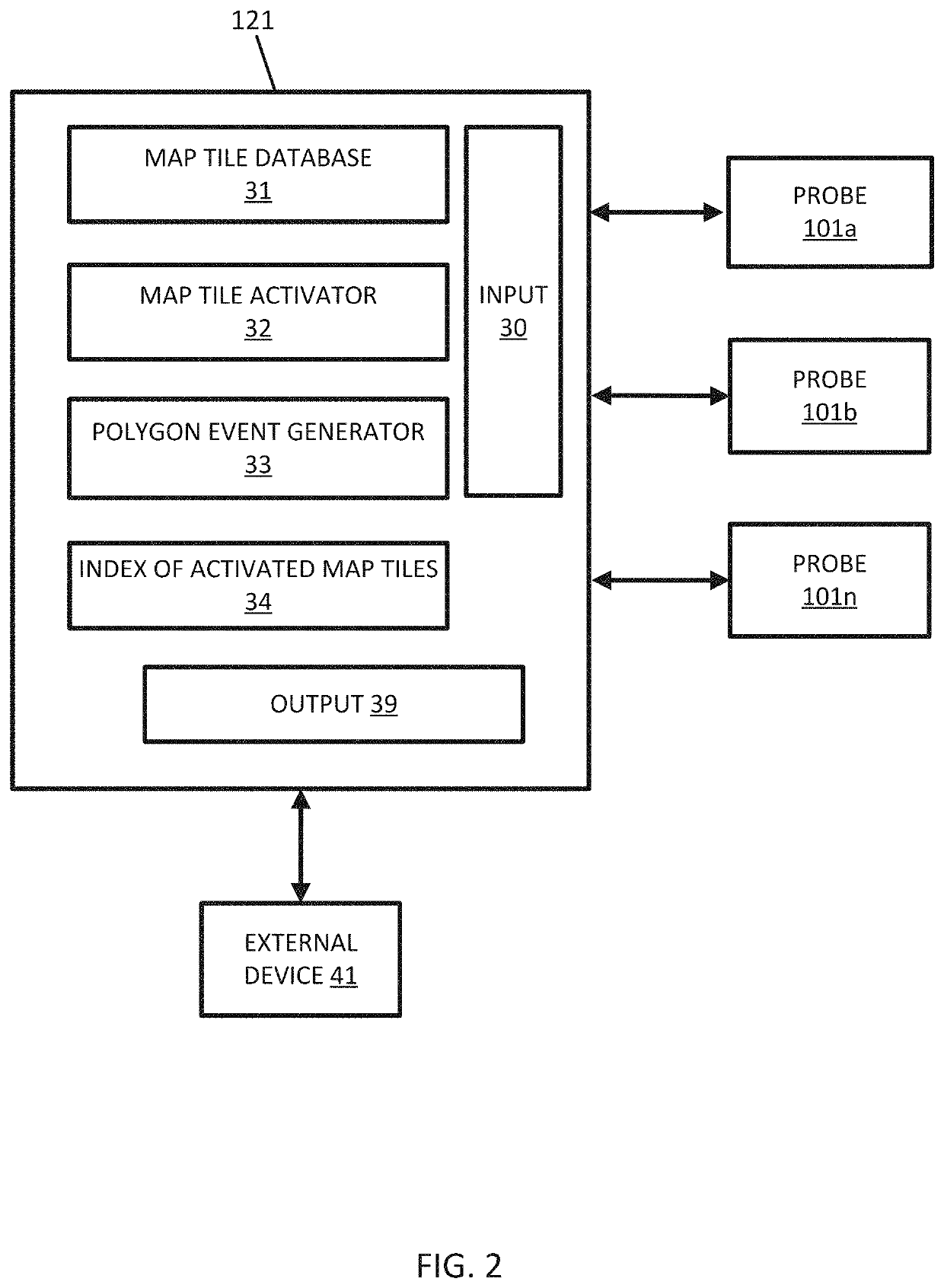
[0150]identifying at least one map tile within a predetermined distance to the at least one location;

[0151]defining an index including the at least one map tile in response to identification that the at least one map tile is within the predetermined distance to the at least one location;

[0152]calculating, by a processor, a confidence level for the at least one map tile accessed from the index;

[0153]comparing, by the processor, the confidence level for the at least one map tile to a threshold confidence level;

[0154]clustering the at least one map tile in a map tile cluster in response to the confidence level exceeding the threshold confidence level; and

[0155]calculating, by the processor, a polygon based on the map...

embodiment 2

[0156]The method of embodiment 1, further comprising:

[0157]calculating a centroid of the at least one map tile, wherein the confidence level is for the centroid of the at least one map tile.

embodiment 3

[0158]The method of any of embodiments 1 and 2,

[0159]generating a map including the polygon and the geographic region.


PUM


Abstract

An apparatus is configured to perform a method for generating warning polygons for weather events in a geographic region. The method includes receiving measurement data from one or more sensors, identifying at least one location from the measurement data, identifying a map tile within a predetermined distance to the at least one location, defining an index including the map tile in response to identification that the map tile is within the predetermined distance to the at least one location, calculating a confidence level for the map tile accessed from the index, comparing the confidence level for the map tile to a threshold confidence level, clustering the map tile in a map tile cluster in response to the confidence level exceeding the threshold level, and calculating a polygon based on the map tile cluster such that the polygon intersects the geographic region.

Description

FIELD[0001]The following disclosure relates to the calculation of polygons for geographic areas corresponding to weather events from vehicle sensor data.BACKGROUND[0002]Driving conditions change very quickly. The path of a rain storm, fog, or other weather conditions moves across different roadways in a geographic area in different ways and in different coverage areas. These weather conditions can be hazardous to drivers. The weather conditions may be detected by sensors at some vehicles. Warnings may be provided to other vehicles. When warnings can be delivered to drivers, the drivers can prepare for the upcoming conditions. Drivers may choose to slow down, change lanes, exit the road, or stop on the shoulder. Safety is improved, and accidents are avoided.[0003]Warnings are delivered to drivers via connected navigation systems and can be displayed on the head unit screen, cluster screen or a heads-up display. The affected region for the warnings may also be rendered at the vehicle ...

Claims


Application Information

Patent Timeline
Patent Type & Authority Patents(United States)
IPC IPC(8): G01C21/36G06K9/00G06F3/0481G05D1/02G06T11/20
CPCG06F3/04817G05D1/0274G01C21/3694G06T11/203G06K9/00791G01C21/3691G01W1/02G01W2001/006G01C21/3804G01C21/3881G01C21/3867G06V20/56
Inventor STENNETH, LEON
Owner HERE GLOBAL BV
Why Eureka
Try Eureka