Method of planning a route to a destination

a route planning and destination technology, applied in surveying and navigation, instruments, navigation instruments, etc., can solve the problems of traffic delays, traffic jams, and system providing route planning becoming more susceptible to errors, and achieve the effect of time of arrival at each destination

Inactive Publication Date: 2007-05-10
TOMTOM INT BV
View PDF9 Cites 208 Cited by
  • Summary
  • Abstract
  • Description
  • Claims
  • Application Information

AI Technical Summary

Benefits of technology

[0019] The present invention combines the geographical coverage possible with fixed, pre-defined route segment costs (e.g. the legal speed limit) with, wherever possible, richer time dependent costs. A user of, for example, a portable navigation device, can therefore continue route planning as before to virtually any destination in a country covered by the stored map database, but wherever possible, can also use traffic data with time-dependent costs, so that the effect of congestion with any time predictability can be accurately taken into account as an automatic, background process. It leaves the user to simply carry on driving, following the guidance offered by the navigation device, without needing to be concerned about congestion that exists now, and whether it will impact his journey.
[0033] Using the above method, a route can be planned to a destination, or two or more destinations, and the time of arrival at each destination will be significantly more accurate than current speed limit based approaches.

Problems solved by technology

The costs of traffic delays can be very large.
Such systems have begun to incorporate traffic information into their services, but this is not integrated into the route selection; the user can observe delays where they impact the selected route, and manually guide the system to re-plan a route avoiding the delayed sections of road if they consider this necessary.
As road congestion increases, systems providing route planning become more susceptible to error.
A driver will not be pleased to ask for the fastest route from A to B, and then find themselves caught in a traffic jam for 50 minutes.
The cost can be reviewed, but this is as expensive as the original cost assignment.
These map databases, from companies like TeleAtlas and NavTech, are the result of hugely costly and thorough surveying of roads, usually throughout an entire country.
But its weakness is that the assumption of travel at the legal speed limit clearly breaks down for congested areas because the devices do not have reliable traffic information.
The general approach for calculating a lowest cost route (e.g. quickest) can be thought of as comprehensive, but inaccurate if congestion occurs.
But these systems have been limited mainly to major roads because of the infrastructure costs of developing the monitoring equipment (e.g. loop sensors buried in roads; camera based systems, such as number plate recognition systems) or because they rely on floating vehicle systems in which a relatively small proportion of all vehicles (equipped with dedicated hardware) are tracked, typically those moving on major roads and not urban areas.
Overall, traffic monitoring services are not at all comprehensive, but useful when congestion occurs on a road that is monitored.
But the usefulness is limited for two reasons.
Secondly, the congestion may have cleared by the time that the vehicle reaches the places that is indicated as being congested right now.
But to date, as noted above, this kind of data has typically only been applied to traffic monitoring systems that provide data for a relatively small proportion of roads in a country.
The overall effect is that a user can use route planning algorithms with time-dependent route segment costs, but is limited to route planning for the relatively small proportion of roads that are covered by the traffic monitoring system.
Geographical coverage is available, but at the expense of accuracy.

Method used


Image

  • Method of planning a route to a destination
  • Method of planning a route to a destination
  • Method of planning a route to a destination

Examples


Embodiment Construction

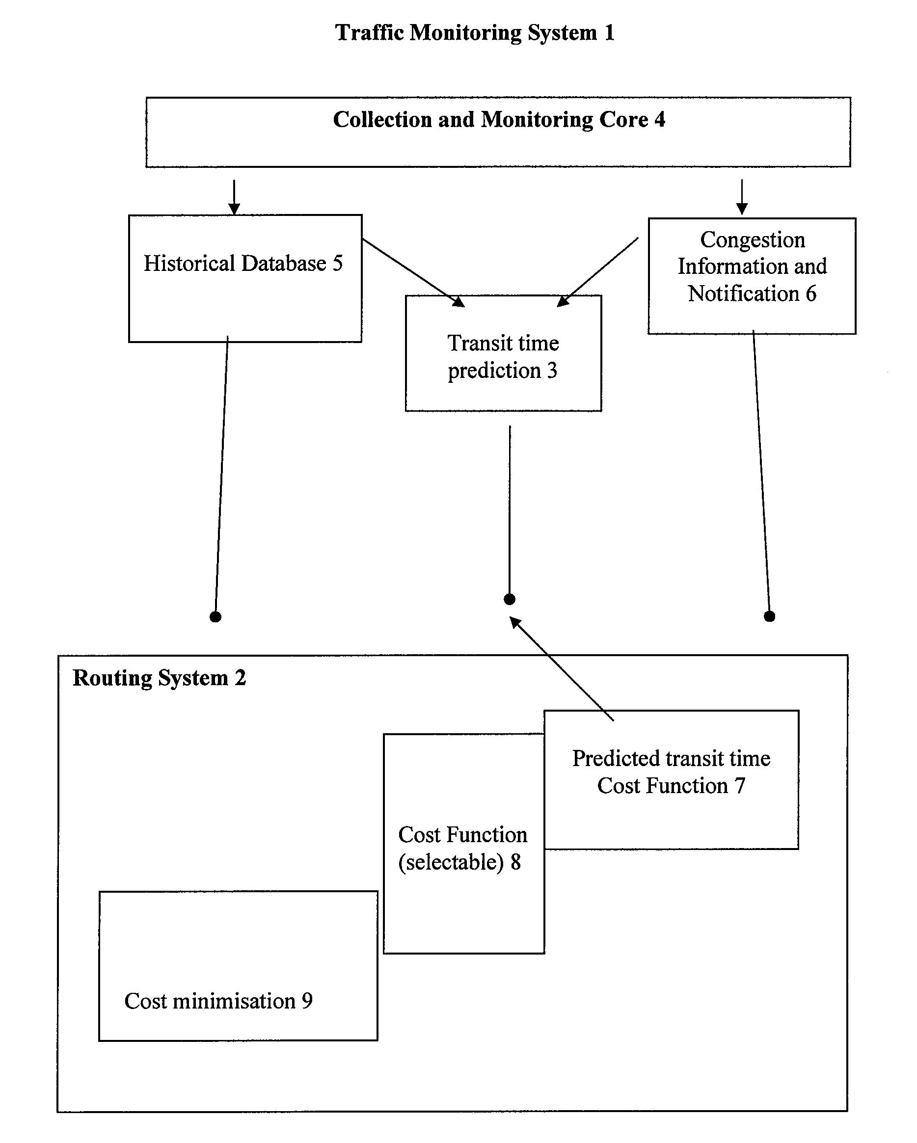
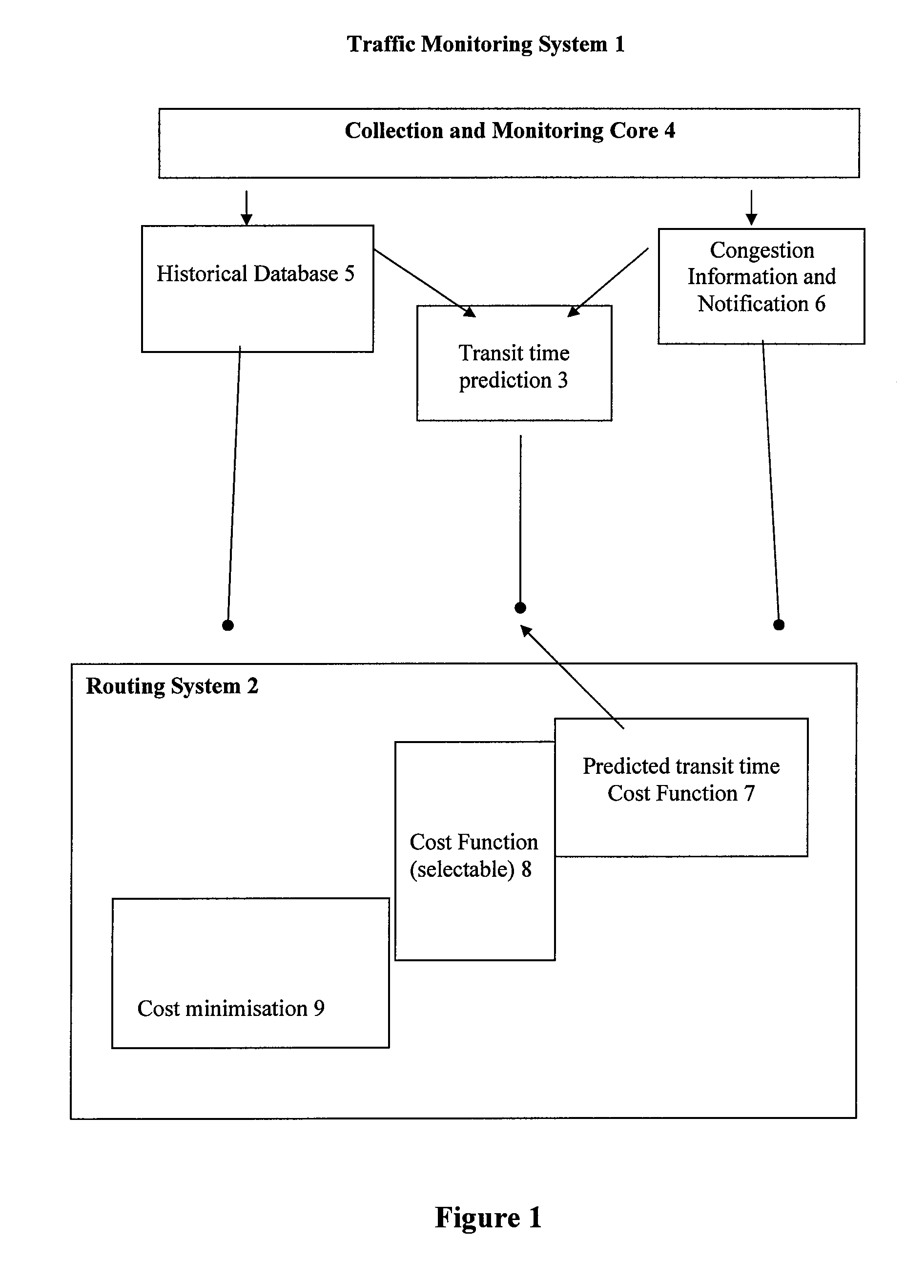
[0058] Various facilities exist for proposing a route on a road network to a driver who wishes to make a specific journey. The journey may be simply specified as between two points, or may be a more complex journey involving multiple locations which must be visited, not necessarily in a particular order. This is the kind of journey that a delivery driver would make. Whatever the form of the journey, the aim is to minimize a cost associated with the journey. The most obvious cost is the time duration, but any other cost may be relevant, for example the fuel used in making the journey. Users can restrict the choice of roads used, for instance some classes of commercial vehicles are prohibited from using all routes except Trunk routes when outside conurbations. These facilities are most usually embodied as computer systems encapsulating algorithms which assign a cost to a section of route, and which apply a cost minimization algorithm [Dijkstra] to the graph of junctions and routes. In...


PUM


Abstract

The present invention combines the geographical coverage possible with fixed, pre-defined route segment costs (e.g. the legal speed limit) with, wherever possible, richer time dependent costs. A user of, for example, a portable navigation device, can therefore continue route planning as before to virtually any destination in a country covered by the stored map database, but wherever possible, can also use traffic data with time-dependent costs, so that the effect of congestion with any time predictability can be accurately taken into account as an automatic, background process. It leaves the user to simply carry on driving, following the guidance offered by the navigation device, without needing to be concerned about congestion that exists now, and whether it will impact his journey.

Description

BACKGROUND OF THE INVENTION [0001] 1. Field of the Invention [0002] This invention relates to a method of planning a route to a destination; it finds application in computer implemented systems that enable an optimal driving route to be planned. [0003] 2. Description of the Prior Art [0004] Road travel is a major part of everyday life for business and other organizations, and for private individuals. The costs of traffic delays can be very large. The purely financial cost has been estimated as billions of pounds in the UK alone [CFIT]. Given these costs, systems which can assist drivers to optimize their travel, for instance by selecting the best route and by avoiding congestion delays, are of significant value. In fact a diverse array of driver information systems have grown up: [0005] Longest established are broadcast radio traffic reports which aggregate data from a number of sources (police, eye-in-the-sky, and more recently mobile phone calls from drivers stuck in jams) to prov...

Claims


Application Information

Patent Timeline
Patent Type & Authority Applications(United States)
IPC IPC(8): G01C21/32G01C21/34G08G1/0968G08G1/0969
CPCG01C21/3492G08G1/096827G08G1/00G08G1/096883G08G1/0969G08G1/096844G01C21/26G01C21/34G08G1/0104G08G1/0968
Inventor ADAM, THOMAS BRUCE WATSONATKINSON, IAN MALCOMDIXON, MICHAEL JOSEPH
Owner TOMTOM INT BV
Why Eureka
Try Eureka