Eureka AIR delivers breakthrough ideas for toughest innovation challenges, trusted by R&D personnel around the world.

Method for filing roadways included on digital maps

Inactive Publication Date: 2008-08-28
DEUTSCHES ZENTRUM FUER LUFT & RAUMFAHRT EV
View PDF9 Cites 2 Cited by
  • Summary
  • Abstract
  • Description
  • Claims
  • Application Information

AI Technical Summary

Benefits of technology

[0007]It is therefore an object of the invention to specify an improved method which allows roadways on digital maps to be filed highly accurately and with a memory space saving.
[0010]It is therefore possible for the roadway not to be filed as the set of its measurement points, as previously, but rather for the roadway now to be described by a series of functions. This allows the volume of data per roadway to be significantly reduced, since it is no longer necessary to file each measurement point individually.
[0013]It is also advantageous if, when the roadways are divided into segments, the length of the segments is chosen such that it is at a maximum. In other words, that is to say that, in order to keep down the volume of data as far as possible, the roadways are divided into segments such that the number of segments per roadway is as small as possible. However, a segment must not be chosen to be too long, since otherwise the function associated with the segment no longer approximates the dotted line with sufficient accuracy.
[0014]It is therefore particularly advantageous if the length of the segments is chosen on the basis of a power function, so that it is possible to ensure that the segment functions describe the dotted lines in the segments with sufficient accuracy. The power function can accordingly identify, as a quality function, whether the segment function describes the segment with sufficient accuracy or whether the relevant segment has been chosen to be too long. It is thus conceivable, by way of example, for the power function to ascertain the discrepancy between the dotted line in the segment and the curve shape of the segment function, this discrepancy being able to be taken as a basis for altering the length of the segment.

Problems solved by technology

In this context, the road shape is approximated only very coarsely by straight lines, which results in inaccuracies which can be ignored when the maps are used for navigation, however.
A drawback in this context is that the multiplicity of measurement points required means that the volume of data per roadway is enormous, so that both the data management and the data transmission or remote data transmission have associated additional costs.
The digital road maps used for navigation cannot be used in this case because their accuracy is not sufficient for the remit described above.

Method used


Image

  • Method for filing roadways included on digital maps
  • Method for filing roadways included on digital maps
  • Method for filing roadways included on digital maps

Examples


Embodiment Construction

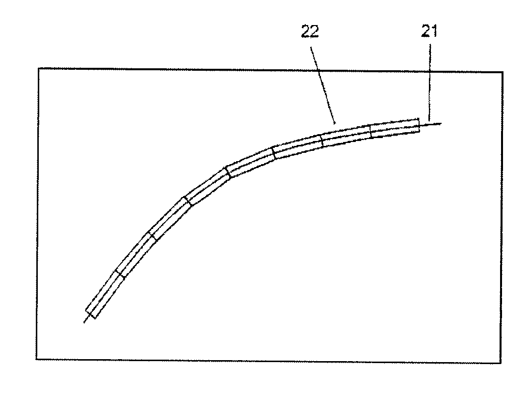
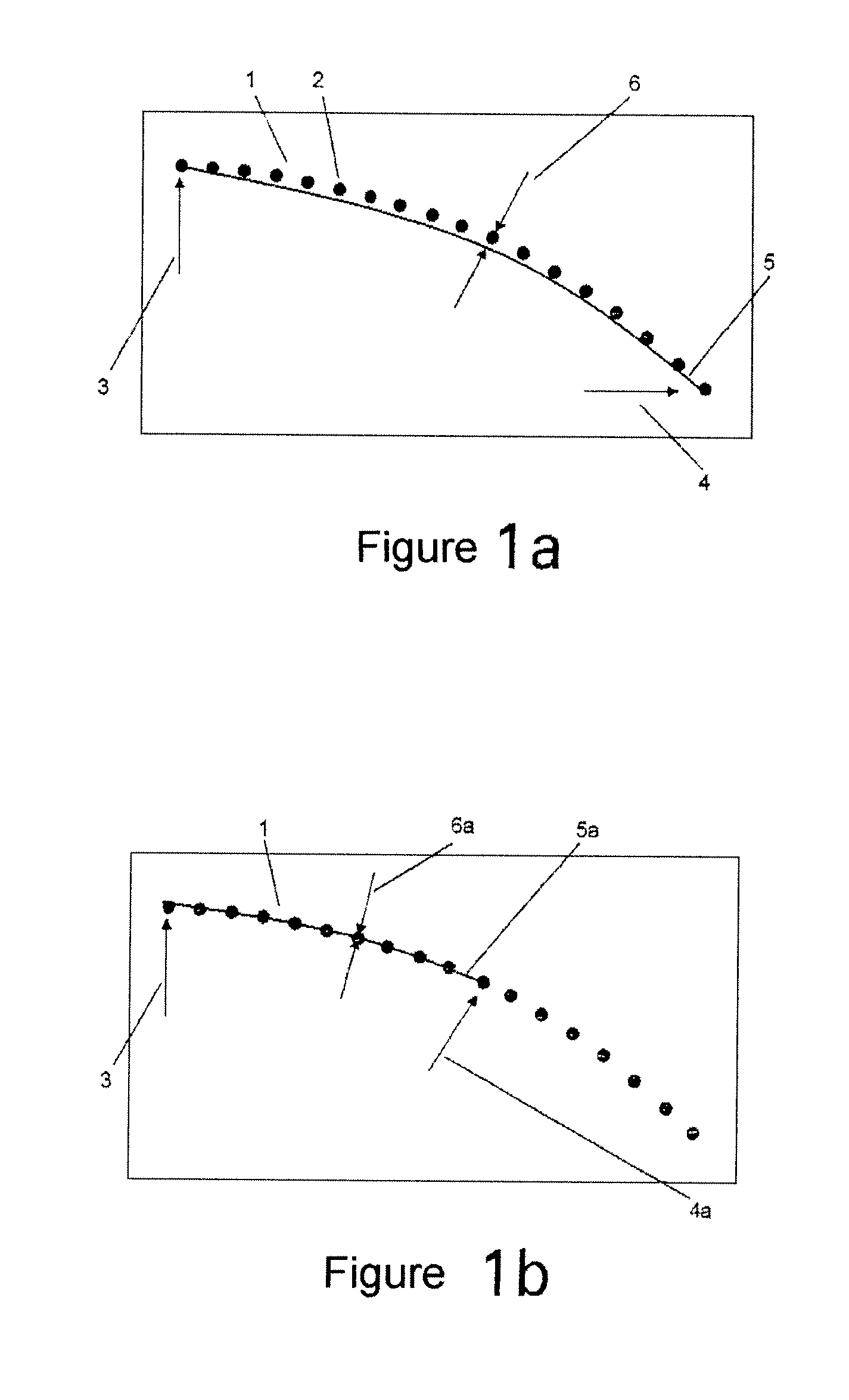
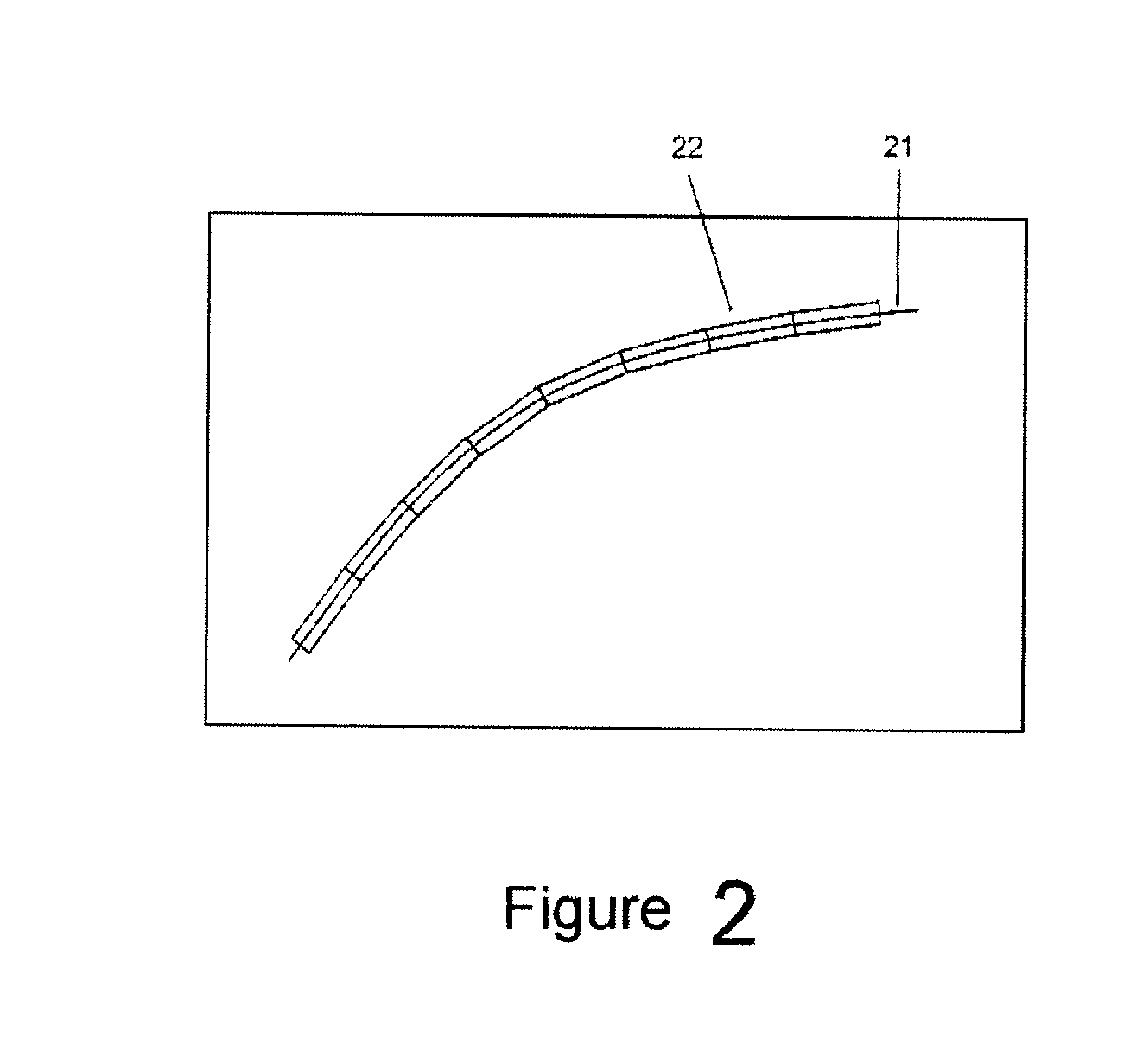
[0022]FIG. 1a shows the result following a first segmentation step. In this case, the relevant segment comprises a dotted line 1, comprising a plurality of measurement points 2. The segment is formed by a start 3 and an end 4, with a segment function having been ascertained in-between whose curve shape 5 approximates the dotted line 1.

[0023]A subsequent step is used to ascertain whether the curve shape 5 of the segment function approximates the dotted line 1 with sufficient accuracy. To this end, the interval 6 between the dotted line 1 and the curve shape 5 of the segment function is determined and a check is performed to determine whether this interval exceeds the previously defined threshold value. The interval 6 is thus a qualitative measure of the approximation.

[0024]If it is established that the curve shape 5 of the segment function does not approximate the dotted line 1 with sufficient accuracy, the relevant segment needs to be shortened. This is shown schematically in FIG. 1...


PUM


Abstract

The invention relates to a method for filing roadways which are included on digital maps and which comprise dotted lines formed by a multiplicity of measurement points, where the roadways are divided into a plurality of segments, a segment function is ascertained for each segment on the basis of the dotted line in the relevant segment, and the roadways are thus filed as the set of their segment functions.

Description

BACKGROUND OF THE INVENTION[0001]1. Field of the Invention[0002]The invention relates to a method for filing roadways which are included on digital maps and which comprise dotted lines formed by a multiplicity of measurement points.[0003]2. Description of the Related Art[0004]The roadways included on digital maps, such as roads or rails, normally comprise a multiplicity of measurement points which together form a dotted line and hence characterize the relevant roadway. To obtain such a dotted line, the relevant roadway must first of all be surveyed in advance using a suitable measuring apparatus. Normally, this is done by traveling along the relevant roadway, with the position being continually ascertained and stored during this time. From this multiplicity of measurement points, it is then possible to form a dotted line which represents the relevant roadway.[0005]From these measurement points and dotted lines, it is then possible to file the roadways which are required for digital ...

Claims


Application Information

Patent Timeline
IPC IPC(8): G06F17/30
CPCG01C21/32G01C21/3819
Inventor NOYER, ULFNIEHOFF, NICO
Owner DEUTSCHES ZENTRUM FUER LUFT & RAUMFAHRT EV
Why Eureka
Eureka Blog
Learn More