Navigation device and method

a navigation device and navigation method technology, applied in navigation instruments, surveying and navigation, instruments, etc., can solve problems such as inability to achieve, user mislead or confusion, and achieve the effect of reducing memory resource requirements

Inactive Publication Date: 2008-09-18
TOMTOM INT BV
View PDF0 Cites 88 Cited by
  • Summary
  • Abstract
  • Description
  • Claims
  • Application Information

AI Technical Summary

Benefits of technology

[0038]Most preferably, the landmark data is in the form of approximated shape information, for example by being represented using one or more known mathematical methods such as splines, parameterized sin( ) waves, in order to minimize memory resource requirements within the device.

Problems solved by technology

Ideally, in the case where processing power was of no concern and display capabilities were limitless, the ideal display would be a digital high resolution representation of the view currently seen by the user wherever she might be, such continuously changing as the device moved, but of course this is currently not achievable, and therefore a basic graphical representation of information is currently adopted.
In particular, in hilly areas where there is very little information displayed, or in busy cities where there is very little time to make decisions on account of traffic density, it is possible for users to be mislead or confused.

Method used


Image

  • Navigation device and method
  • Navigation device and method
  • Navigation device and method

Examples


Embodiment Construction

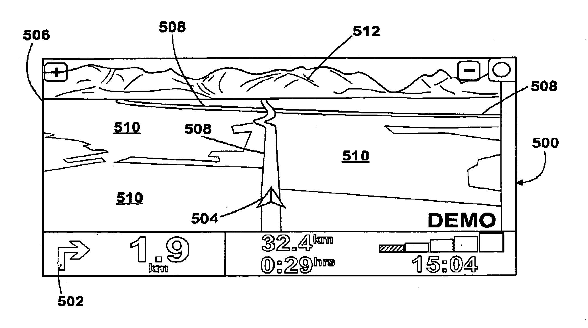
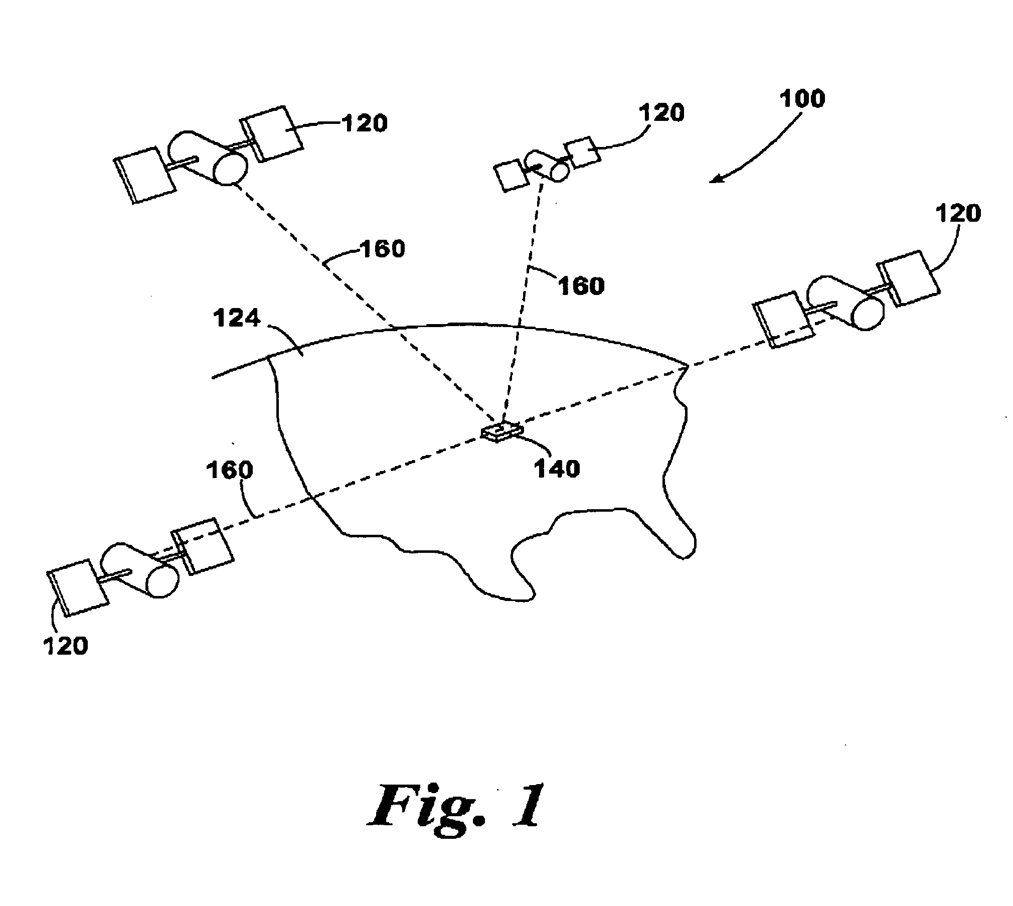
[0048]FIG. 1 illustrates an example view of Global Positioning System (GPS), usable by navigation devices. Such systems are known and are used for a variety of purposes. In general, GPS is a satellite-radio based navigation system capable of determining continuous position, velocity, time, and in some instances direction information for an unlimited number of users. Formerly known as NAVSTAR, the GPS incorporates a plurality of satellites which work with the earth in extremely precise orbits. Based on these precise orbits, GPS satellites can relay their location to any number of receiving units.

[0049]The GPS system is implemented when a device, specially equipped to receive GPS data, begins scanning radio frequencies for GPS satellite signals. Upon receiving a radio signal from a GPS satellite, the device determines the precise location of that satellite via one of a plurality of different conventional methods. The device will continue scanning, in most instances, for signals until ...


PUM


Abstract

A method of operating a navigation device, and a correspondingly adapted navigation device are described. The method includes the steps of representing stored map data visually on a display screen together with a graphical representation of the current device location, and is characterized by the further steps of determining a boundary distance forward and/or to one side of the current location of the device, determining from map data whether any ancillary elevation or landmark data is available within, or within a predetermined distance of, the boundary distance, such distance optionally being translated as may be appropriate to correspond to the map data, and causing display of one or more graphical visualizations representing elevated features or landmarks in conjunction with the visually represented map data.

Description

PRIORITY STATEMENT[0001]The present application hereby claims priority under 35 U.S.C. § 119(e) on U.S. Provisional Patent Application No. 60 / 879,584 filed Jan. 10, 2007, the entire contents of which is hereby incorporated herein by reference.FIELD OF THE INVENTION[0002]This invention relates to an improved navigation device and method.[0003]Although the following description relates primarily to portable navigation devices (PNDs), it will be instantly appreciated by the reader that the invention is equally applicable to navigation systems being comprised of the same intrinsic functional components, but which are generally integrated into the body of some larger vehicle and are thus not generally removable therefrom. A navigation device, as the term is used hereinafter, is intended to cover both PNDs and navigation systems, and the description hereinafter provided relating to PNDs will be found equally applicable to navigation systems.BACKGROUND OF THE INVENTION[0004]PNDs including ...

Claims


Application Information

Patent Timeline
Patent Type & Authority Applications(United States)
IPC IPC(8): G01C21/00
CPCG01C21/3638
Inventor GEELEN, PIETERTKACHENKO, SERHIY
Owner TOMTOM INT BV
Why Eureka
Try Eureka