Techniques for representing location information

a technology of location information and representation techniques, applied in surveying and navigation, navigation instruments, instruments, etc., can solve the problems of insufficient representation of hundreds (if not thousands) of locations in the five boroughs, inconvenient scrolling of the list of locations, and insufficient representation of conventional techniques

Active Publication Date: 2009-01-22
R2 SOLUTIONS
View PDF5 Cites 107 Cited by
  • Summary
  • Abstract
  • Description
  • Claims
  • Application Information

AI Technical Summary

Problems solved by technology

Unfortunately, such conventional representations have inherent limitations depending, for example, on the scope of the geographic area represented (e.g., the map magnification or zoom level), or the size of the display on which the information is presented
For example, if a user of a mobile device wants to see all of the Italian restaurants in New York City, conventional techniques would clearly be inadequate fo...

Method used


Image

  • Techniques for representing location information
  • Techniques for representing location information
  • Techniques for representing location information

Examples


Embodiment Construction

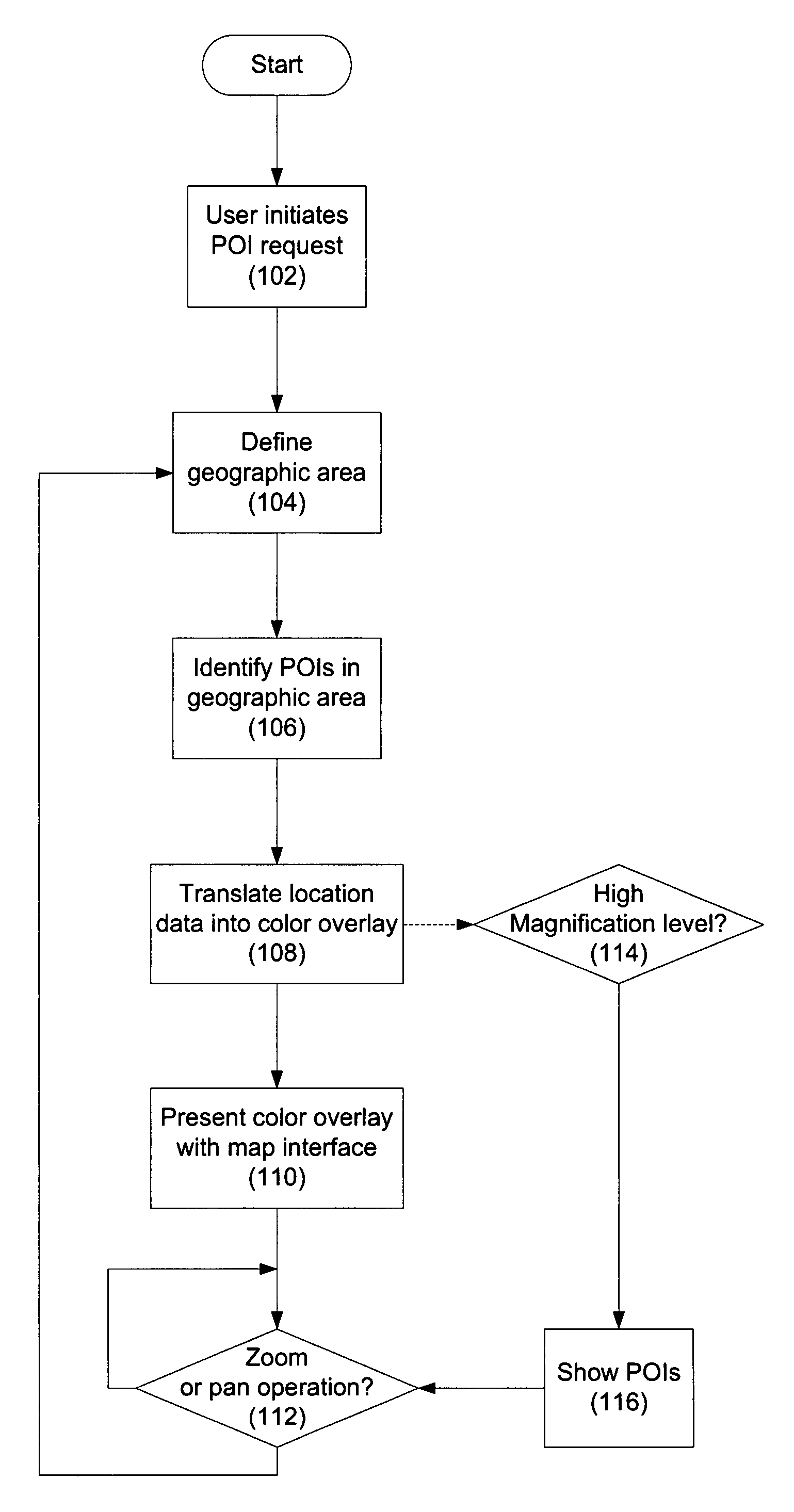
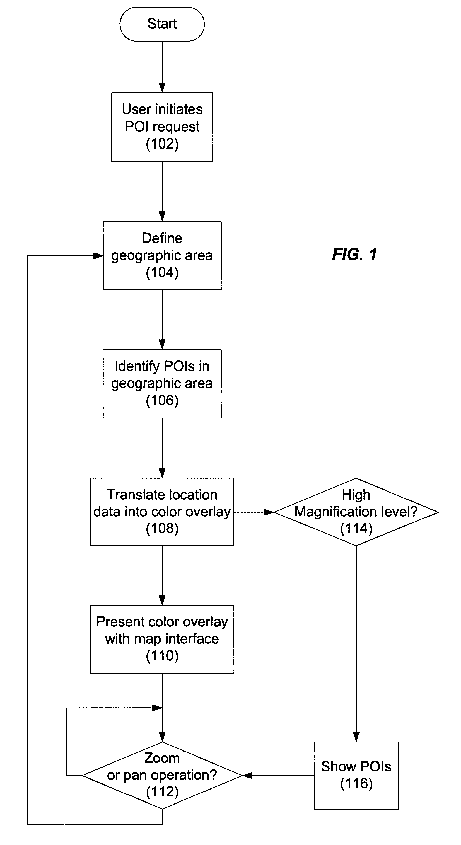
[0009]Reference will now be made in detail to specific embodiments of the invention including the best modes contemplated by the inventors for carrying out the invention. Examples of these specific embodiments are illustrated in the accompanying drawings. While the invention is described in conjunction with these specific embodiments, it will be understood that it is not intended to limit the invention to the described embodiments. On the contrary, it is intended to cover alternatives, modifications, and equivalents as may be included within the spirit and scope of the invention as defined by the appended claims. In the following description, specific details are set forth in order to provide a thorough understanding of the present invention. The present invention may be practiced without some or all of these specific details. In addition, well known features may not have been described in detail to avoid unnecessarily obscuring the invention.

[0010]Embodiments of the present inventi...


PUM


Abstract

Methods and apparatus are described for representing points of interest relative to a user-defined geographic area in a map interface. Representation of the geographic area and a plurality of point-of-interest (POI) locations corresponding to the points of interest is facilitated in the map interface using a color scheme in which variations in color represent variations in density of the POI locations within the geographic area.

Description

BACKGROUND OF THE INVENTION[0001]The present invention relates to representing points of interest in map interfaces and, in particular, to the use of color schemes to represent the density of points of interest.[0002]Location-related applications employ a variety of techniques to represent points of interest in map interfaces. For example, locations are often represented using various types of icon graphics which may be accompanied by text representing the type or even the name of the corresponding location. Alternatively, locations may be represented in a list ordered by their respective distance from a particular location. Unfortunately, such conventional representations have inherent limitations depending, for example, on the scope of the geographic area represented (e.g., the map magnification or zoom level), or the size of the display on which the information is presented[0003]For example, if a user of a mobile device wants to see all of the Italian restaurants in New York City...

Claims


Application Information

Patent Timeline
IPC IPC(8): G08G1/0969G01C21/00
CPCG01C21/367G08G1/0969G01C21/3682
Inventor SCHEIBE, BERND
Owner R2 SOLUTIONS
Why Eureka
Try Eureka