Method for manufacturing raised relief maps

a technology of raised relief and manufacturing methods, applied in the direction of additive manufacturing apparatus, etc., can solve the problems of low map surface color and image quality, low manufacturing cost, and low resolution molds, and achieve the effect of low cost, low manufacturing cost and high manufacturing cos

Inactive Publication Date: 2010-04-29
HIGGINS MICHAEL H
View PDF3 Cites 54 Cited by
  • Summary
  • Abstract
  • Description
  • Claims
  • Application Information

AI Technical Summary

Problems solved by technology

These traditional methods of terrain mold making result in both lower resolution molds and a higher manufacturing cost.
The resulting shape of the scaled model of the terrain is of high resolution, but is heavy, smal

Method used


Image

  • Method for manufacturing raised relief maps
  • Method for manufacturing raised relief maps
  • Method for manufacturing raised relief maps

Examples


Embodiment Construction

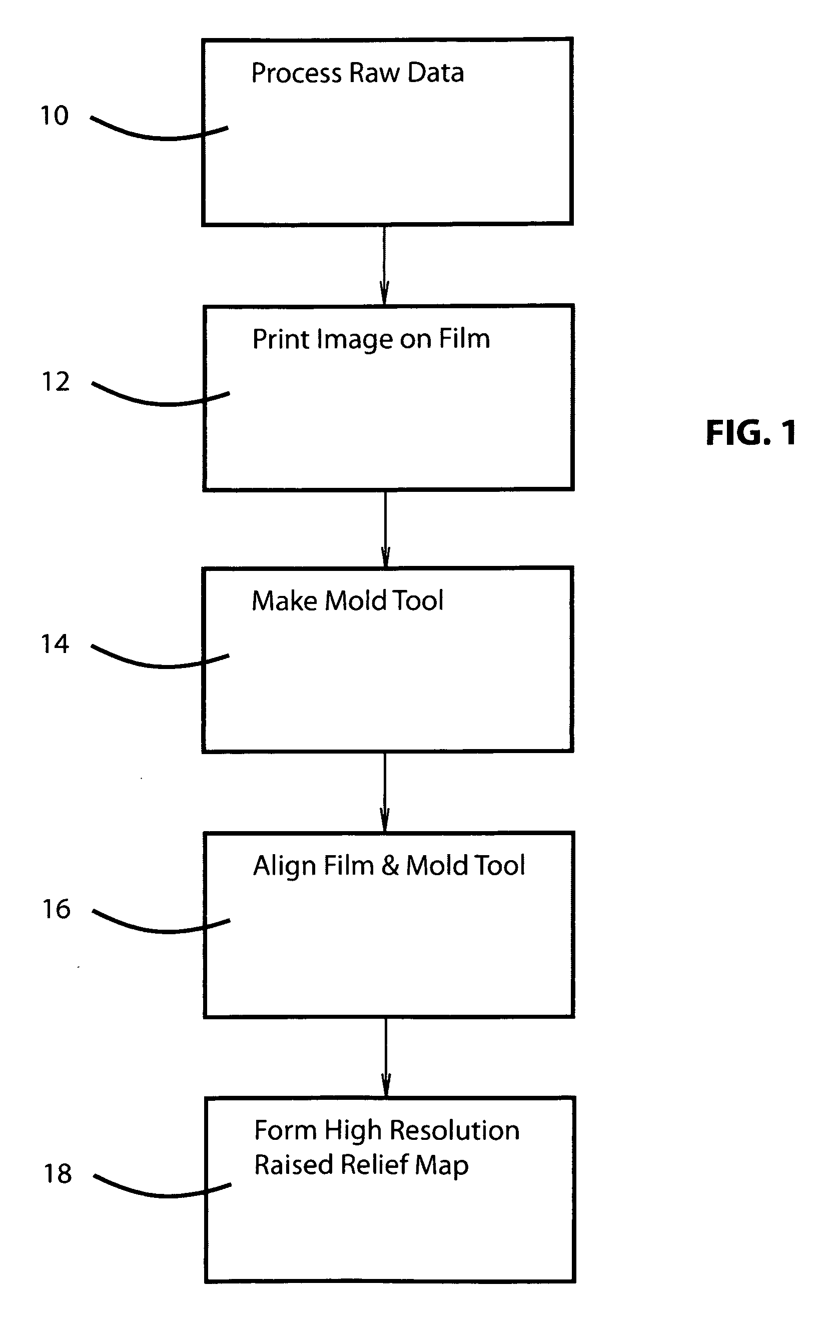
[0020]There is shown in FIG. 1 a block diagram of a method of making a very high resolution relief map. The method includes the processing of raw terrain elevation data which includes manipulation of the data to account for slope and other non-flat characteristics of the final map, as indicated at 10. The processed image is then printed on film as indicated at 12. The terrain elevation data is then used to make a thermoforming mold tool as indicated at 14. The printed film and mold tool are then aligned in a thermoforming machine as indicated at 16 and the high resolution relief map is formed as indicated at 18. This method will now be described in detail below.

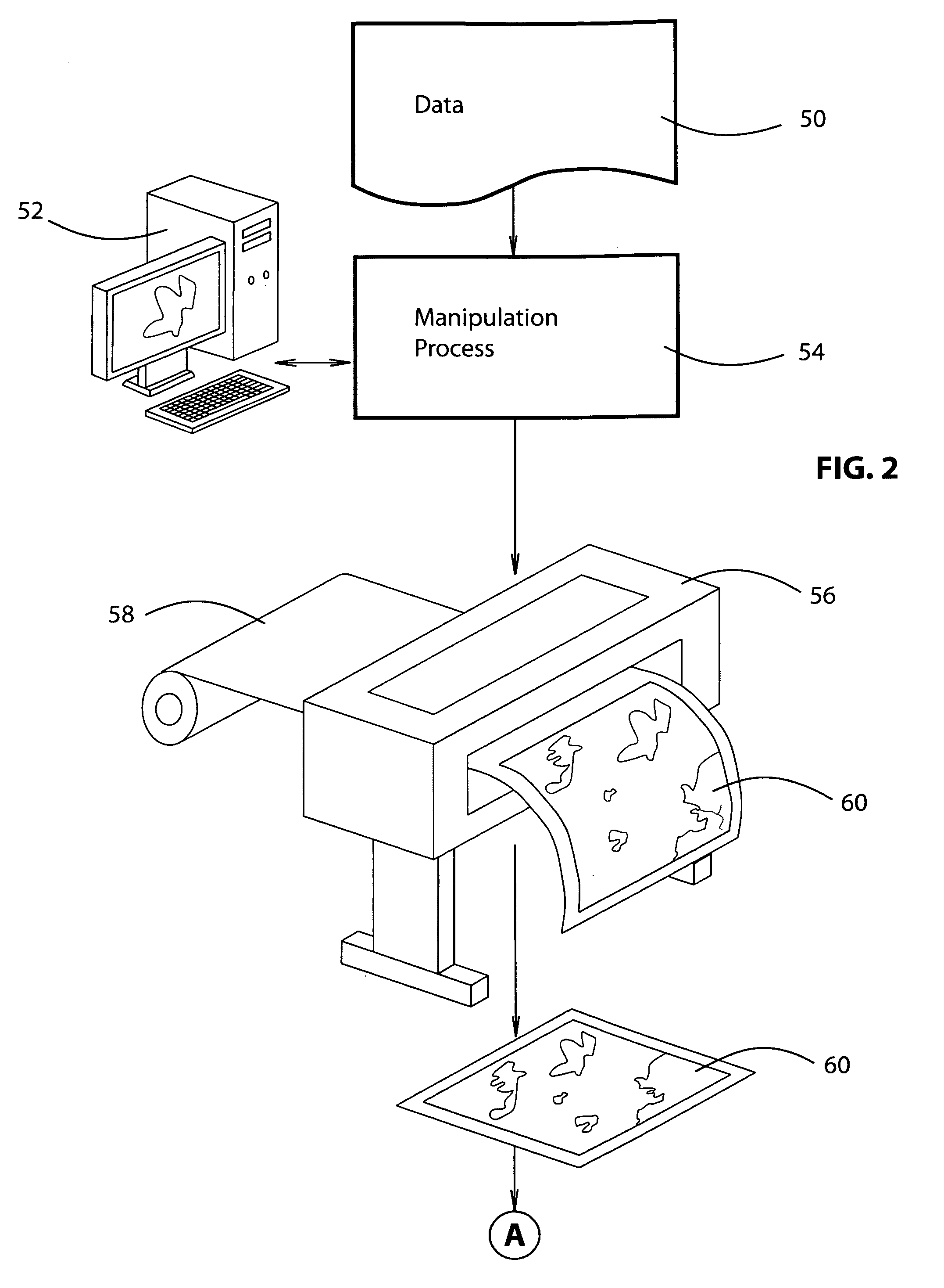
[0021]As shown in FIG. 2, raw topographical and image data 50 is input into the system either manually or electronically, and may be manipulated by a computer 52 to account for different geographical systems / projections and variations in slope of the contoured three dimensional map surface. This image data manipulation proces...


PUM

PropertyMeasurementUnit
Resolution enthalpyaaaaaaaaaa

Abstract

A method of making a very high resolution raised relief map (190) includes making a very high resolution mold form (82) by means of a rapid-prototyping process such as a three-dimensional printer (80). A high resolution three-dimensional surface (90) is formed on the mold and a thin formable plastic film (60) having high resolution features pre printed thereon is positioned in precise alignment with corresponding features on the mold form. The thin plastic film is then thermoformed against the high resolution surface of the mold to make the high resolution raised relief map (190).

Description

[0001]The present invention relates to raised relief maps and more particularly to a method of making very high resolution raised relief maps.BACKGROUND OF THE INVENTION[0002]Raised relief maps of geographic areas model the shape of the surface of the earth, showing approximate variations in elevation over the area of interest along with regular map features such as roads, boundaries, feature names, and other thematic detail. Such raised relief maps have an extensive range of applications, including education such as classroom geography, history, geology, and geopolitical as well as recreation such as hiking, kayaking, mountain climbing, and skiing. Other areas of application include aviation for pilot flight planning, advertising / media, military tactical planning, and government functions. These three dimensional maps are normally made by vacuum forming a flexible plastic printed sheet against a formed surface of a mold which models the terrain shape. The surface of the plastic fil...

Claims


Application Information

Patent Timeline
IPC IPC(8): B29C35/04
CPCB29C33/3835B29C33/3842B29C33/42B29C2795/002B29C51/36B29C67/0051B29C2791/006B29C51/08B33Y80/00
Inventor HIGGINS, MICHAEL H.
Owner HIGGINS MICHAEL H
Why Eureka
Try Eureka