Electronic map apparatus and electronic map display method

a technology of electronic map and electronic map, which is applied in the direction of editing/combining figures or text, navigation instruments, instruments, etc., can solve the problems of difficult to know the geographical distance instantaneously, difficult to know the geographical distance in a direction slanting with respect to a longitude or latitude line, and much more difficult to intuitively and quickly know the actual geographical distan

Inactive Publication Date: 2010-09-16
SONY CORP
View PDF13 Cites 14 Cited by
  • Summary
  • Abstract
  • Description
  • Claims
  • Application Information

AI Technical Summary

Benefits of technology

[0009]In order to solve the problems described above, the present invention provides an electronic map apparatus comprising: data fetching means for fetching map data from media for storing the map data to be displayed as a map; a display device for displaying the map in accordance with the map data; and a microcomputer for processing data of a circle or an arc which has a center at a specified point on the map and links points on the map at equal geographical distances from the center, wherein the circle or the arc is displayed on the map displayed on the display device in accordance with the data processed by the microcomputer.
[0009]In order to solve the problems described above, the present invention provides an electronic map apparatus comprising: data fetching means for fetching map data from media for storing the map data to be displayed as a map; a display device for displaying the map in accordance with the map data; and a microcomputer for processing data of a circle or an arc which has a center at a specified point on the map and links points on the map at equal geographical distances from the center, wherein the circle or the arc is displayed on the map displayed on the display device in accordance with the data processed by the microcomputer.

Problems solved by technology

In the case of such a display method, however, in an attempt to know the approximate geographical distance between the present position of the vehicle and the destination of the vehicle such as a location or a building while driving the vehicle, it is difficult to know the geographical distance instantaneously.
Particularly, it is more difficult to know a geographical distance in a direction slanting with respect to a longitude or latitude line.
It is thus much more difficult to intuitively and speedily know an actual geographical distance.

Method used


Image

  • Electronic map apparatus and electronic map display method
  • Electronic map apparatus and electronic map display method
  • Electronic map apparatus and electronic map display method

Examples


Embodiment Construction

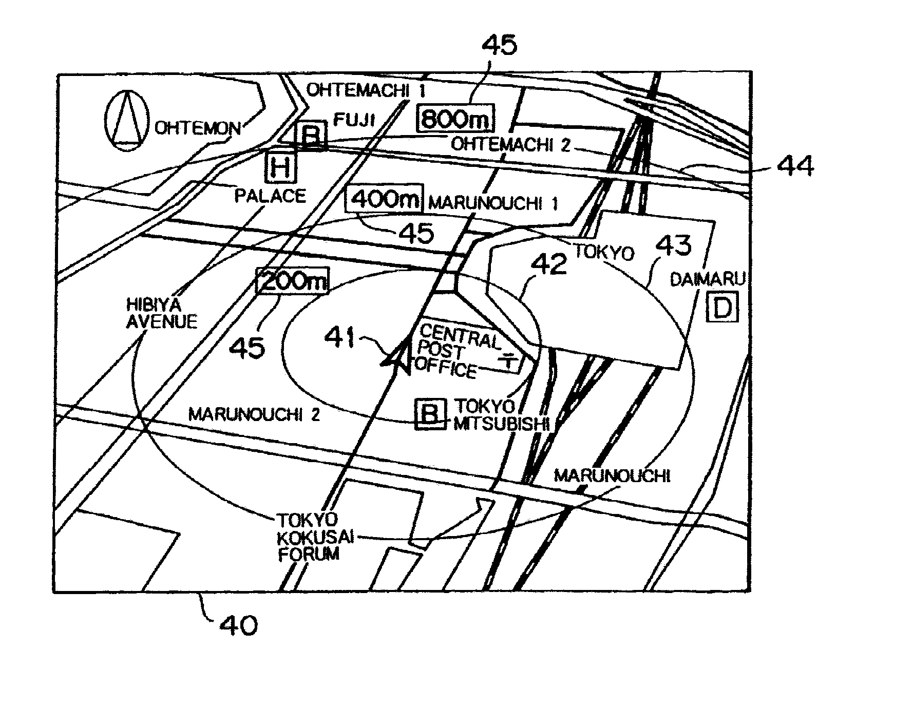
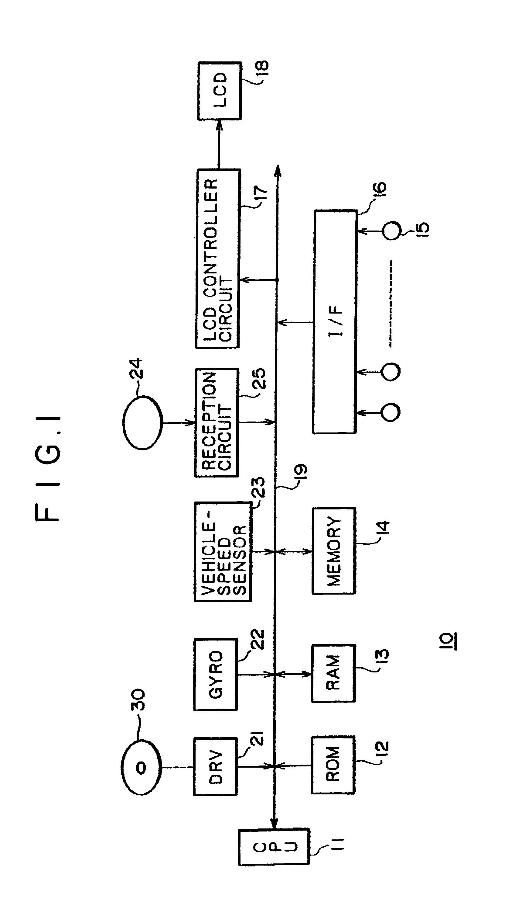
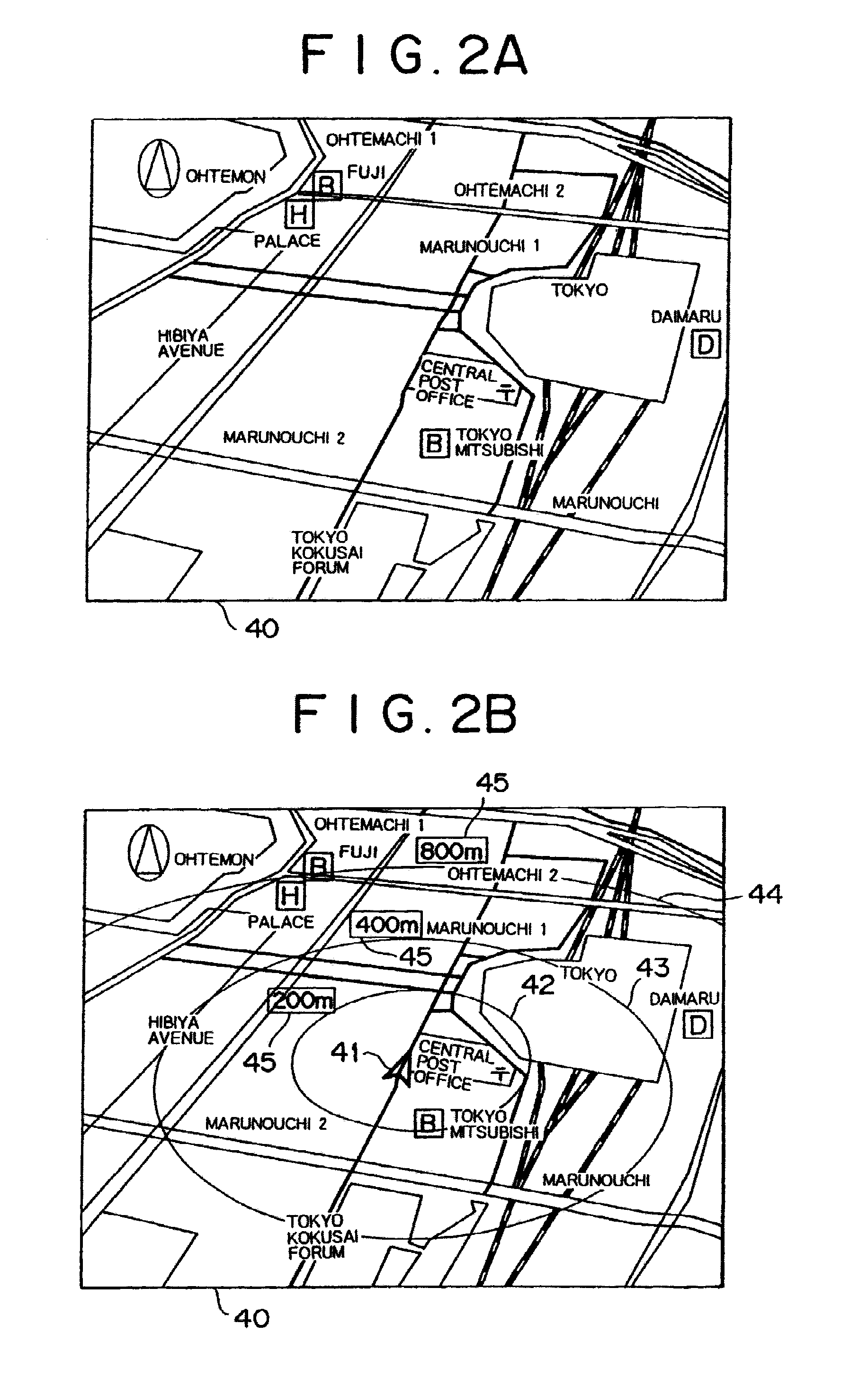
[0017]An onboard navigation apparatus mounted on a vehicle is normally provided with a function to display the position of the vehicle on an electronic map appearing on a display unit.

[0018]In addition, with an onboard navigation apparatus mounted on a vehicle or electronic map viewer application software, the user is allowed to scroll an electronic map appearing on a display unit by operating components such as a cursor key and a mouse. In order to clearly indicate a location serving as an object of operation after the scroll processing, normally, the application software displays a cross-shaped cursor or a finger mark as a scroll center mark at a position in close proximity to the center of the map.

[0019]The present invention allows the user to know a geographical distance on an electronic map speedily and intuitively by focusing on these points.

[0020]In the following description, the present invention is exemplified by an embodiment as applied to an onboard navigation apparatus m...


PUM


Abstract

In an electronic map apparatus, an electronic map is displayed in accordance with map data read out from a DVD-ROM. Then, distance display circles which have a common center located at a point on the electronic map and each interconnect points on the electronic map at equal geographical distances from the point are drawn.As a result, it is possible to know an approximate geographical distance to a destination intuitively and easily in the electronic map apparatus which is typically used for car navigation.

Description

BACKGROUND OF THE INVENTION[0001]The present invention relates to an electronic map apparatus and a method of displaying an electronic map.[0002]In an onboard navigation apparatus mounted on a vehicle, a map is displayed on a display unit in accordance with map data read out from a memory such as a CD-ROM. Typically, there is provided a function to draw lines along longitude and latitude lines, superposing the lines on the map at predetermined intervals to form a shape resembling a checkerboard as shown in FIG. 6A.[0003]Thus, by using this drawing function, for example, it is possible to know an approximate geographical distance between the present position of the vehicle and a destination of the vehicle such as a location or a building.[0004]In addition, electronic map viewer application software executed on a personal computer, for example, includes a function for displaying a scale showing a geographical distance outside the frame of a displayed map. By using this distance scale,...

Claims


Application Information

Patent Timeline
Patent Type & Authority Applications(United States)
IPC IPC(8): G06F3/048G01C21/00G01C21/36G06T11/60G08G1/0969G09B29/00G09B29/10
CPCG01C21/3667G09B29/106G01C21/3682
Inventor MAEDA, HIROSHIOZU, NOBUHIROTANBATA, IPPEIARAKAWA, EMI
Owner SONY CORP
Why Eureka
Try Eureka