Computerized system and method for determining flood risk

a computerized system and flood risk technology, applied in the field of prediction models for determining flood insurance risks, can solve the problems of $20,000 damage to an average home, more than twice as likely to damage a structure by flood, and damage or loss of possessions, etc., and achieve the effect of accurately reflecting the actual risk faced

Inactive Publication Date: 2014-09-18
AON NAT FLOOD SERVICES INC
View PDF2 Cites 19 Cited by
  • Summary
  • Abstract
  • Description
  • Claims
  • Application Information

AI Technical Summary

Benefits of technology

[0012]Still another embodiment of the current invention may be an interface intended to be used by more knowledgeable users such as insurance brokers or other commercial concerns. Such an interface, in addition to displaying risk map information as previously described, may also be configured to provide discrete risk score information to assist in the identification of potential customers in a geographic area served by the commercial user. Such scores may also be used to preliminarily determine eligibility and estimated cost for flood risk insurance for identified properties. In another embodiment of the present invention, it may be used to set flood insurance premiums. Such an embodiment may allow for the entry of additional information regarding the real property and structures located thereon. Information such as construction details and methods, landscaping, other property improvements and modification, and flood protection improvements, may be entered using a user interface. Once entered, such factors may be used to adjust the calculated risk to more accurately reflect the actual risk faced by the identified property.

Problems solved by technology

It has been calculated that in high risk areas, flooding is more than twice as likely to damage a structure than fire.
Significant property damage or loss of possessions may result from such flooding.
Just one inch of flood water can cause $20,000 damage to an average home.
Generally, basic homeowner's insurance does not cover flood damage, leaving many homeowners exposed to liability for expensive property damage caused by flooding.
Even with periodic updates, many regions are out of date in regards to its flood risk.
NSFHA locations may be outside high risk areas but are still prone to flooding as evidenced by their making up over 20% of insurance claims and one-third of disaster assistance requests due to flooding.
A significant shortcoming of FIRMS and other existing flood risk data is that it is difficult to understand for the average layperson.
In looking at such a representation, an uninformed viewer may not understand what is being viewed and incorrectly assume that his or her real property is not at risk, or conversely, at such great risk that flood insurance would be prohibitively expensive to obtain.
Underwriting an insurance policy solely based on flood risk maps cannot discriminate between individual properties or micro locations within a flood maps grid.
A “no” or “maybe” result creates more of a problem for insurers.
Both results may require a more detailed investigation or result in a sometimes unnecessary refusal to underwrite coverage.
When such a refusal is not based on a definitive risk but instead on a lack of the ability to calculate a risk, an insurance provider may be missing an opportunity to underwrite a policy that would be a favorable risk had the insurance provider been able to more accurately determine the property loss risks associated with flooding.
The map may display flood risks using color coding to display greater and lesser areas of risk.

Method used


Image

  • Computerized system and method for determining flood risk
  • Computerized system and method for determining flood risk
  • Computerized system and method for determining flood risk

Examples


Embodiment Construction

)

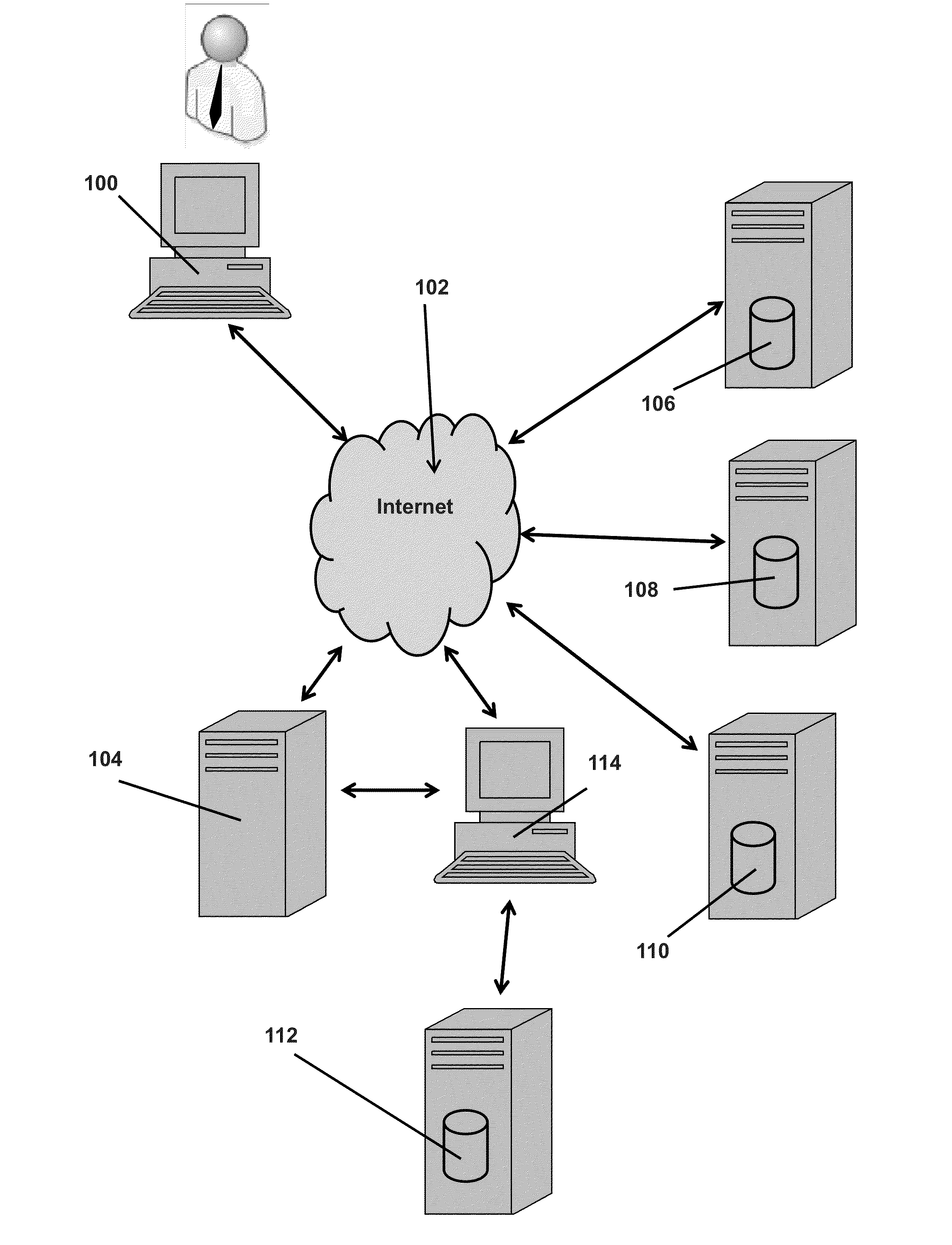
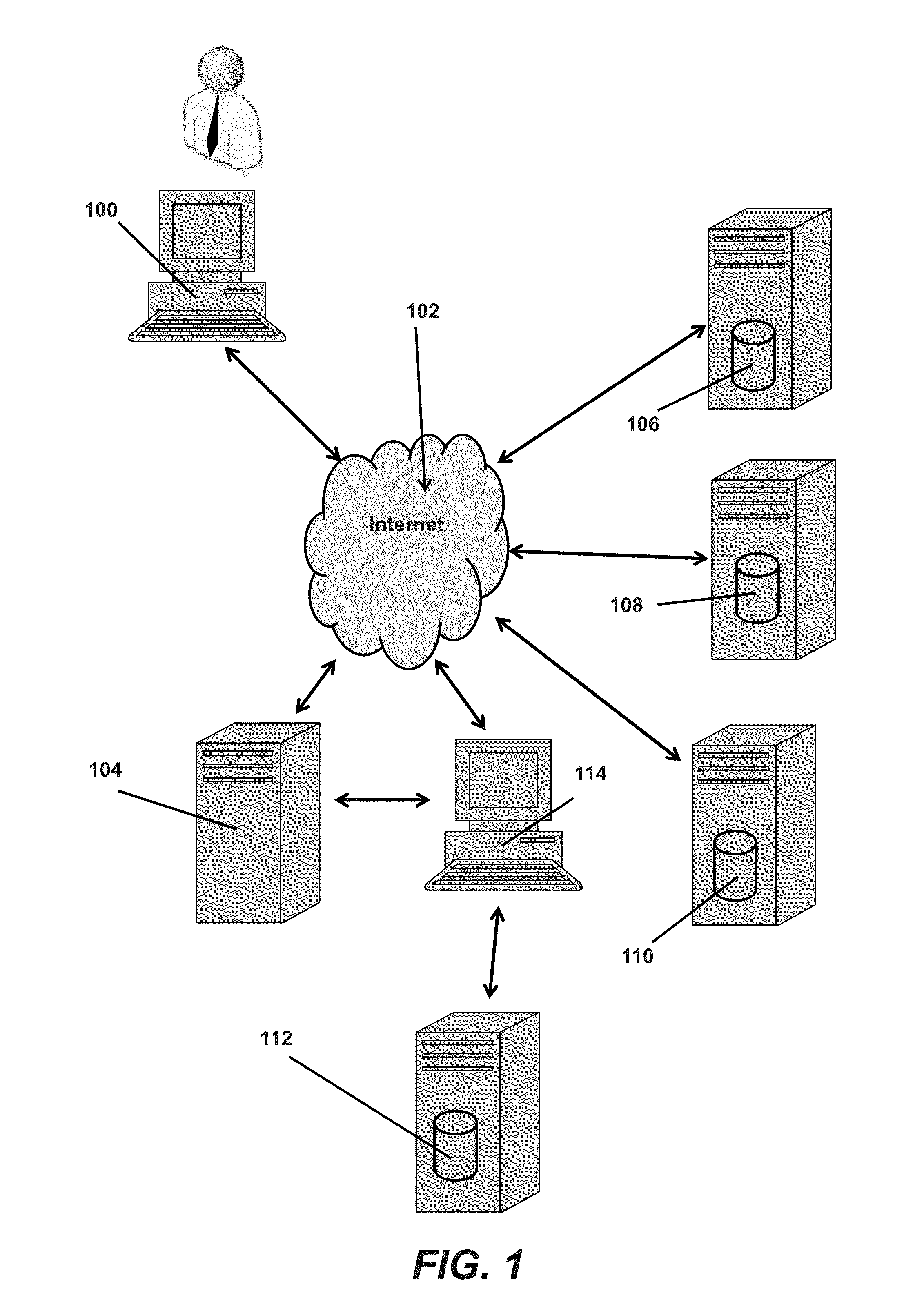
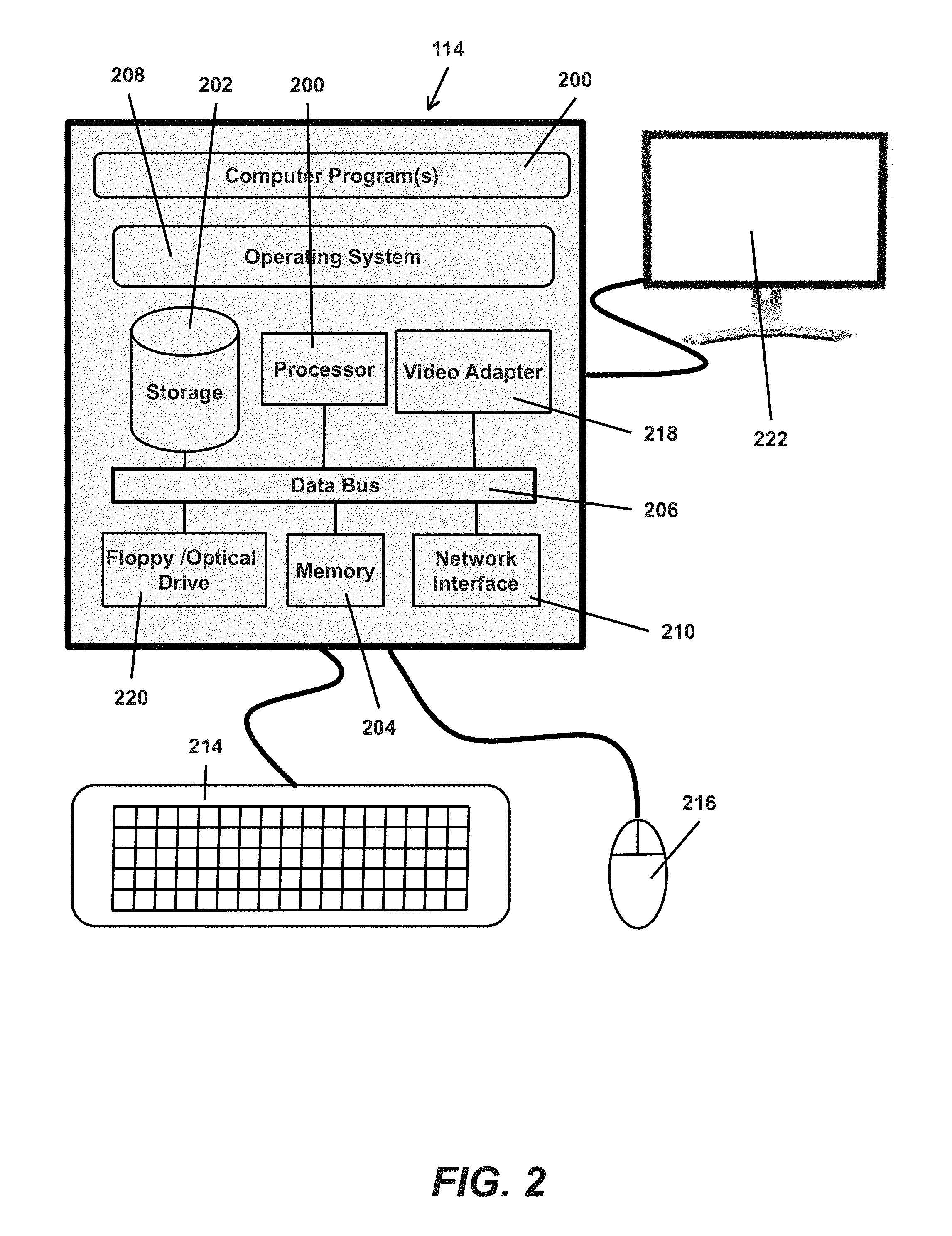
[0024]The disclosed methods may be implemented as computer-executable instructions stored on one or more computer-readable storage media and executed on a computing device. Such devices may include, but are not specifically limited to, commercially available computers, including tablet computers and smart phones or other mobile devices that include computing hardware. The computer-executable instructions for implementing the disclosed techniques as well as any data created and used during implementation of the disclosed embodiments may be stored in one or more computer-readable media. Such instructions can be executed on a single local computer or in a networked computer environment, including a cloud computing network, using one or more network computers.

[0025]As is well known in the art, any of the software-based embodiments may be uploaded, downloaded, or remotely accessed through a suitable communications means. Such suitable communications means may include, for example, the i...


PUM


Abstract

The present invention is a system for communicating the flood risk of a property to a user comprising a computer network, a first computerized device for displaying flood risk information in electronic communication with a computer network, a first database connected to said network, where said first database contains flood zone information arranged by geographic coordinates, a second database connected to said network, where said second database contains terrain elevation data arranged by geographic coordinates, a third database connected to said network, where said third database contains rainfall data arranged by geographic coordinates, a fourth database connected to said network, where said fourth database contains a record of prior flooding arranged by geographic coordinates, a fifth database connected to said network, where said fifth database contains a record of losses arranged by geographic coordinates, and a second computerized device connected to said network which calculates flood risk information for geographic location using an algorithm to process database information contained in said databases.

Description

BACKGROUND AND SUMMARY OF THE INVENTION[0001]Exemplary embodiments of the present invention relate generally to a predictive model for determining insurance risk and, more specifically, flood insurance risk.[0002]Flooding is the most common natural disaster in the United States. It has been calculated that in high risk areas, flooding is more than twice as likely to damage a structure than fire. Floods may be the result of a storm or hurricane, heavy rains, flash floods, ice jams, levees, snowmelt, spring thaw, and new development which changes the natural runoff paths present on the land. Flooding and flash floods can occur in all fifty states.[0003]Significant property damage or loss of possessions may result from such flooding. For example, according to the Federal Emergency Management Agency (“FEMA”), flood losses for US states and territories from Jan. 1, 1978 to Nov. 30, 2012 have been calculated by FEMA to be over $42 trillion. From 2002 to 2011, flood insurance claims averag...

Claims


Application Information

Patent Timeline
Patent Type & Authority Applications(United States)
IPC IPC(8): G06Q40/08
CPCG06Q40/08Y02A10/40
Inventor KNUFFKE, GREG
Owner AON NAT FLOOD SERVICES INC
Why Eureka
Try Eureka