
Spatial crowdsourcing with trustworthy query answering

a crowdsourcing and query technology, applied in the field of data collection, can solve the problems of inability to always trust the tasks performed by workers, the difficulty the impossibility of achieving the effect of ensuring the accuracy of the query, so as to reduce the travel cost, improve the greedy approach, and efficiently improve the approximation

Inactive Publication Date: 2014-11-20
UNIV OF SOUTHERN CALIFORNIA
View PDF11 Cites 52 Cited by
  • Summary
  • Abstract
  • Description
  • Claims
  • Application Information

AI Technical Summary

Benefits of technology

The patent text describes a problem called spatial crowdsourcing, where a set of workers are assigned tasks based on their location. However, there is a risk of workers not performing the tasks correctly, so there is a need to verify the validity of the results. The text proposes an approach called greedy-based heuristics to efficiently assign tasks while satisfying the confidence levels of the workers. The text also discusses the challenges in solving the problem and proposes three approximation algorithms. The text concludes that the proposed approach outperforms other solutions in terms of the number of assigned tasks and workers' travel cost.

Problems solved by technology

However, a major impediment to the practicality and success of any spatial crowdsourcing system is the issue of trust.
The reason is that the tasks performed by workers cannot always be trusted, because the motivation of the workers is not always clear.
For example, in the same scenario, malicious users may also upload incorrect pictures and videos which paint a totally different image of what is occurring.
Some skeptics of crowdsourcing go as far as calling it a garbage-in-garbage-out system due to the issue of trust.
However, most of these work solve the trust issue by incorporating a trusted software / hardware module in the user's mobile device While this protects the sensed data from malicious software manipulation before sending it to the server, it does not protect the data from users who either intentionally (i.e., malicious users) or unintentionally (e.g., making mistakes) perform the tasks incorrectly.
One challenge with spatial crowdsourcing is how to verify the validity of the results provided by workers.
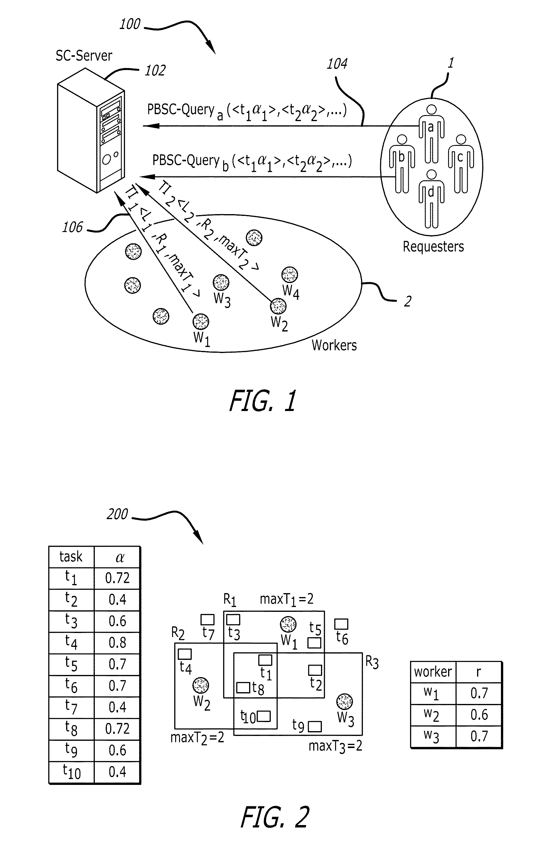
The problem is to maximize the number of spatial tasks assigned to a set of workers while satisfying the confidence levels of those tasks.
However, it is possible that a spatial task cannot be assigned to any individual worker because its confidence is not satisfied by any of the worker's reputation score.
Consequently, the problem turns into maximizing the number of assigned tasks while satisfying the confidence of every task.
Proof is provided that the MCTA problem is NP-hard by reduction from 3D matching problem, which renders the optimal algorithms impractical.
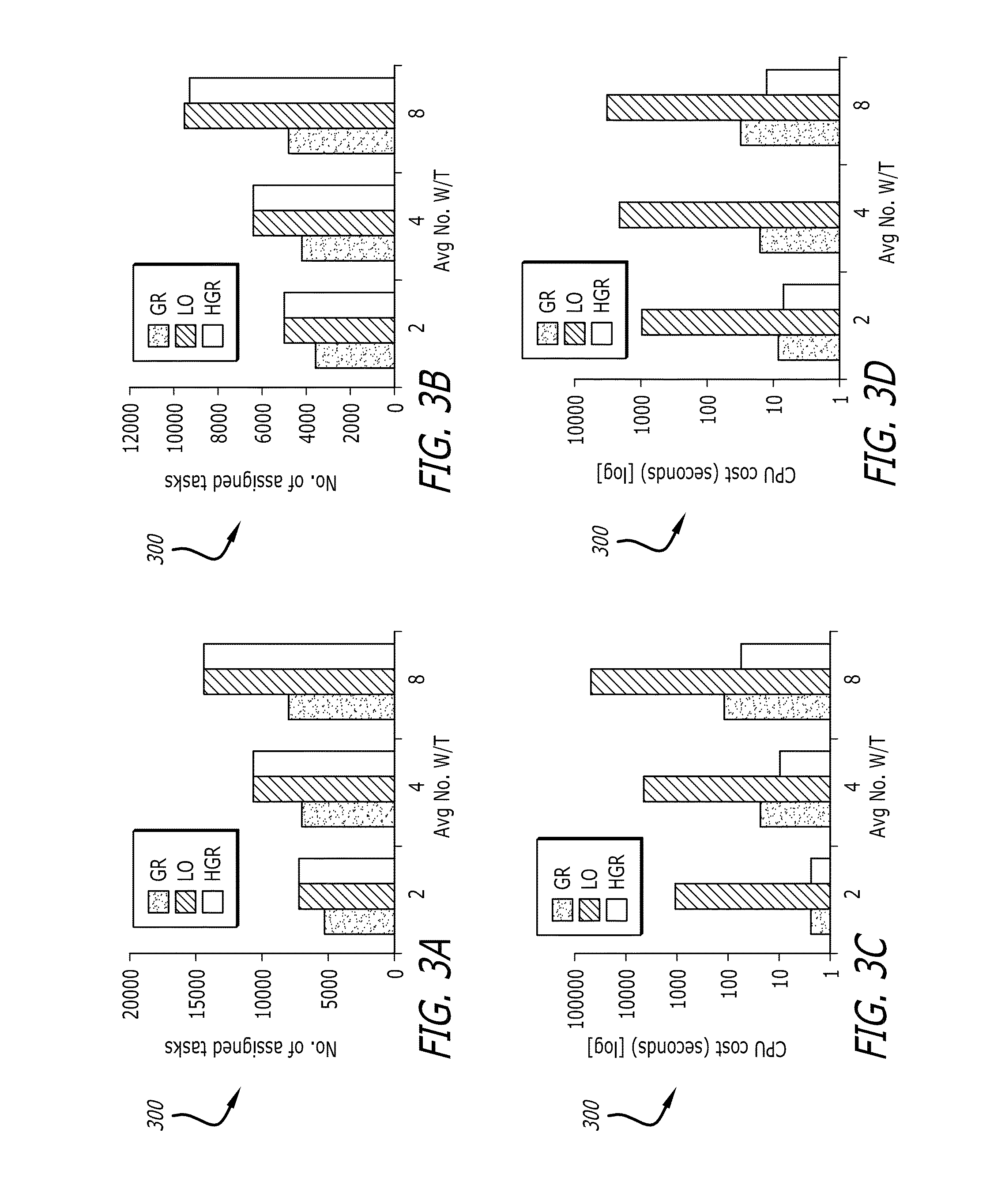
Extensive experiments on both real and synthetic data show that the LO approach is not (currently) readily applicable to the real-world applications due to its significantly high CPU cost.

Method used


Image

  • Spatial crowdsourcing with trustworthy query answering
  • Spatial crowdsourcing with trustworthy query answering
  • Spatial crowdsourcing with trustworthy query answering

Examples


case 1

[0159]FIGS. 15A-B illustrate two cases of FOV's results for range queries in views 15A-15B. Range queries are defined by a given circle, within which all the FOV's are found that overlap with the area of the circle. The resulting FOV f(p, θ, R, α) of the range circle query (q, r) with the center point q and radius r fall into the following two cases:[0160] As shown in FIG. 15A, the camera location is within the query circle, i.e., the distance between the camera location p and the query location q is less than the query radius r of the query circle.[0161]Case 2: As shown in FIG. 15B, although the camera location is outside of the query circle, the area of the FOV partially overlaps with the query circle. Specifically, line segment pp′ intersects with arc , which is formulated in Eqn. 3, where β represents the angle between vector {right arrow over (pq)} and {right arrow over (pp′)}, and p′ denotes any point on the arc of the FOV.

R≧Dist(p,q)×cos β−√{square root over (r2−(Dist(p,q)×s...


PUM


Abstract

Spatial crowdsourcing systems and methods assign spatial tasks to be performed by human workers. The systems and methods can verify the validity of the results provided by workers. Every worker can have a reputation score stating the probability that the worker performs a task correctly. Every spatial task can have a confidence threshold determining the minimum quality of the accepted level of its result. To satisfy this threshold, a task may be assigned redundantly to multiple workers. A reputation score can be associated to every worker, which represents the probability that a worker performs a task correctly. A task may be assigned to a subset of workers whose aggregate reputation score satisfies the confidence of the task.

Description

CROSS-REFERENCE TO RELATED APPLICATIONS[0001]This application is based upon and claims priority to U.S. provisional patent application 61 / 785,510, entitled “GeoCrowd—Next Generation of Data Collection: Harnessing the Power of Crowd for On-Demand Location Scouting,” filed Mar. 14, 2013, attorney docket number 028080-0858.[0002]This application is further based upon and claims priority to U.S. provisional patent application 61 / 829,617, entitled “GeoTruCrowd: Trustworthy Query Answering with Spatial Crowdsourcing,” filed May 31, 2013, attorney docket number 028080-0909.STATEMENT REGARDING FEDERALLY SPONSORED RESEARCH[0003]This invention was made with government support under Grant No. CNS-0831505, awarded by the National Science Foundation (NSF). The government has certain rights in the invention.[0004]The entire content of each of these applications and patents is incorporated herein by reference.BACKGROUND[0005]1. Technical Field[0006]This disclosure relates to collection of data fro...

Claims


Application Information

Patent Timeline
Patent Type & Authority Applications(United States)
IPC IPC(8): G06Q10/06G06F17/18
CPCG06F17/18G06Q10/06311
Inventor SHAHABI, CYRUSKAZEMI, LEYLA
Owner UNIV OF SOUTHERN CALIFORNIA
Learn More