Systems and methods for providing mapping services including route break point recommendations

a technology of geographical mapping and recommendations, applied in wave based measurement systems, navigation instruments, instruments, etc., can solve the problems of unplanned breaks, waste of travel time, unsatisfactory trips, etc., and achieve the effect of convenient user-friendly trip planning and quick and easy addition of points of interes

Active Publication Date: 2015-02-19
VERIZON PATENT & LICENSING INC
View PDF19 Cites 46 Cited by
  • Summary
  • Abstract
  • Description
  • Claims
  • Application Information

AI Technical Summary

Benefits of technology

[0010]The disclosed embodiments allow users to quickly and easily add points of interest (POI) to their trip at suggested travel breaks—making trip planning convenient for the user. In addition, the disclosed embodiments provide suggested travel breaks based on route leg time / distance and POI density and use user travel break preferences.

Problems solved by technology

Although the routes for such trips are often planned out in advance, for example, using the above-mentioned electronic mapping services, the breaks often are not planned out.
This often leads to breaks taking place locations that may not be the best suited for a particular traveler, for example, not in accordance with a user's POI preferences, resulting in an unsatisfactory trip, wasted travel time, and increased fuel consumption.

Method used


Image

  • Systems and methods for providing mapping services including route break point recommendations
  • Systems and methods for providing mapping services including route break point recommendations
  • Systems and methods for providing mapping services including route break point recommendations

Examples


example 1

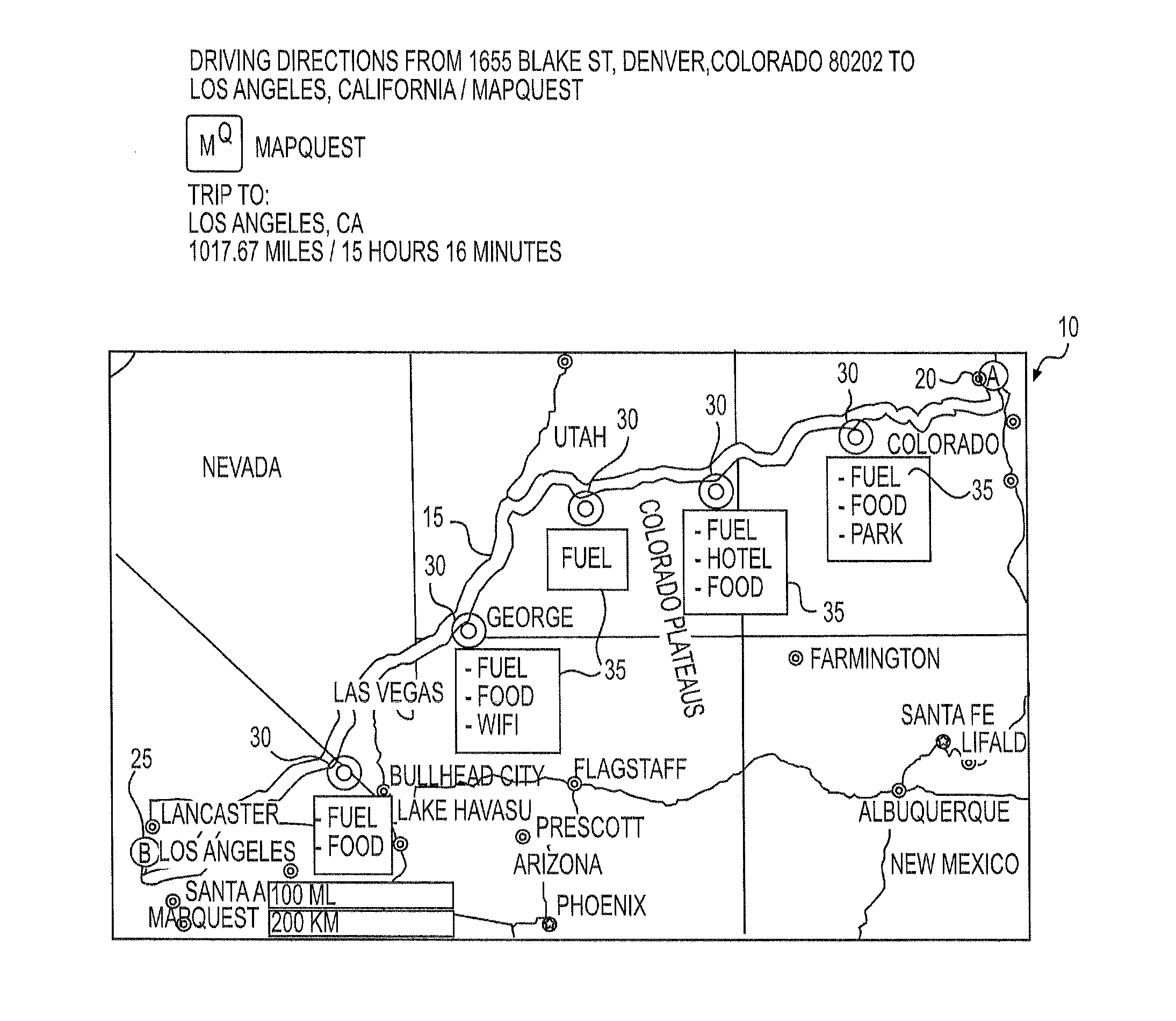
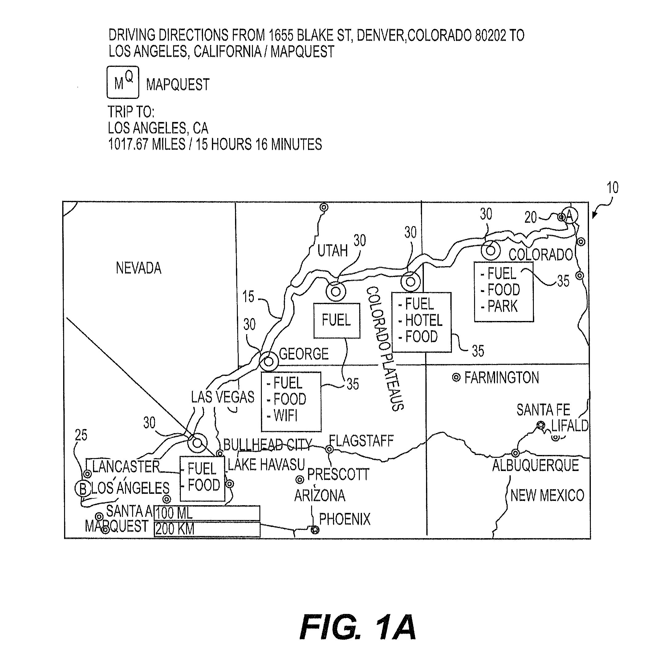
[0056]A user planning a trip from Denver, Colo. to Los Angeles, Calif. uses a mobile phone to input the start (Denver) and destination (LA) locations and is prompted by the electronic device to enter preferred departure time, and any preferences for break point locations. The user inputs, via a touch screen of the electronic device, that the user departure time will be set to the present time, and that the break points should be in close proximity to numerous POIs, including scenic landmarks, and also in close proximity to gourmet coffee shops. The electronic device may prompt the user to determine if the preferences indicated should be saved as a user preferred travel type and the user may indicate “Yes” and name the saved travel type “scenic+coffee,” for later retrieval. The electronic device may retrieve previously saved information regarding the user's vehicle (e.g., miles per gallon and fuel tank capacity) and communicate with the vehicle (e.g., via the vehicle's computer) to o...

example 2

[0059]A user may input the start and destination locations as in Example 1 and select a previous saved travel type, e.g., “with Family” with saved preferences for the break point locations having parks and hotels. The electronic device may provide recommended break points based on the user input.

[0060]FIG. 5 provides a functional block diagram illustration of general purpose computer hardware platforms. FIG. 5 illustrates a network or host computer platform 500, as may typically be used to implement a server like the mapping services server system 135. It is believed that those skilled in the art are familiar with the structure, programming and general operation of such computer equipment and as a result the drawings should be self-explanatory.

[0061]A platform for a server or the like 500, for example, may include a data communication interface for packet data communication 560. The platform may also include a central processing unit (CPU) 520, in the form of one or more processors,...


PUM


Abstract

Computer implemented methods are disclosed for providing geographical information to a user. One method may include receiving, from a user's electronic device and over a network, user input data including at least the destination location and a break point parameter and calculating one or more routes from the start location to the destination location, based on the user input data. The method may also include identifying one or more intermediate break point locations along the one or more routes based on the break point parameter received from the user and identifying a range extending around each intermediate break point location, and potential break points. A step may also be executed in which a density or type of points of interest within each potential break point may be evaluated by the electronic device and a recommended for a break point made.

Description

TECHNICAL FIELD[0001]Various embodiments of the present disclosure relate generally to providing geographical mapping information and recommendations. More specifically, exemplary embodiments of the present disclosure relate to systems and methods for providing user customizable break point recommendations for a trip, based in part on user input.BACKGROUND[0002]Recently, the use of electronic maps has become wide-spread on in-vehicle or portable GPS devices, applications on mobile devices, or other devices. Such electronic maps often convey information about roads, traffic, buildings, landmarks, terrain, etc., related to geographical regions of interest. Some electronic maps may be interactive, allowing users, for example, to view a map of a particular location (e.g., specific address, city, state, country, etc.) and the surrounding locations. A user may also use the map to receive route information to a particular address, either when stationary or while travelling, by various GPS ...

Claims


Application Information

Patent Timeline
Patent Type & Authority Applications(United States)
IPC IPC(8): G01C21/34G01C21/36
CPCG01C21/362G01C21/343G01C21/3682G01C21/20G01C21/3407
Inventor GEARHART, G. DUANESTEINKE, SCOTT W.
Owner VERIZON PATENT & LICENSING INC
Why Eureka
Try Eureka