Postal Fabric Generation

a postage fabric and postage technology, applied in the field of postage fabric generation, can solve the problems of unsuitable postal code representation, unsuitable boundaries for marketing analysis and visualization, unsuitable geographical or logistical areas, etc., and achieve the effect of more granularity and precis

Inactive Publication Date: 2016-08-04
DMTI SPATIAL INC
View PDF0 Cites 7 Cited by
  • Summary
  • Abstract
  • Description
  • Claims
  • Application Information

AI Technical Summary

Benefits of technology

[0004]According to an embodiment of the disclosed subject matter, a system and method is provided to create polygons representing multiple-digit postal codes (for example, six-digit postal codes, and wherein digits can include letters, numbers, or combinations thereof) and defined by attribution information and / or other spatial features thereby providing more granular and precise entities to optimize activities such as trade area analysis and visualization. The results can be stored and provided as analysis data or illustrated using, for example, a visual map.

Problems solved by technology

However, the creation of such cells is not well suited for postal code representation, since such cells can create undesirable boundaries.
For example, such boundaries may unsuitably span geographical or logistical areas and become poorly suited for marketing analysis and visualization.
Further, it is not desirable to have postal code boundaries where no addresses points support the given postal code.

Method used


Image

  • Postal Fabric Generation
  • Postal Fabric Generation
  • Postal Fabric Generation

Examples


Embodiment Construction

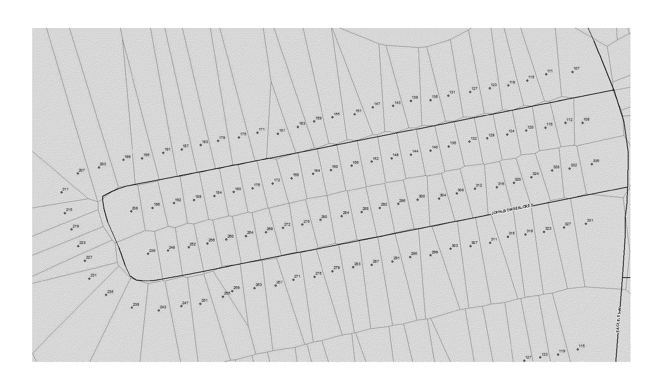
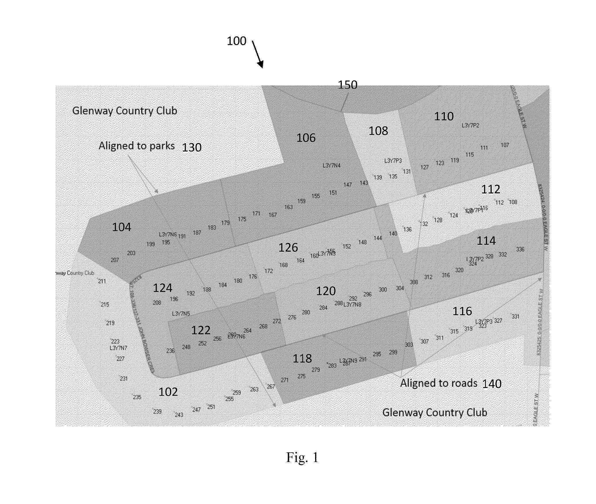
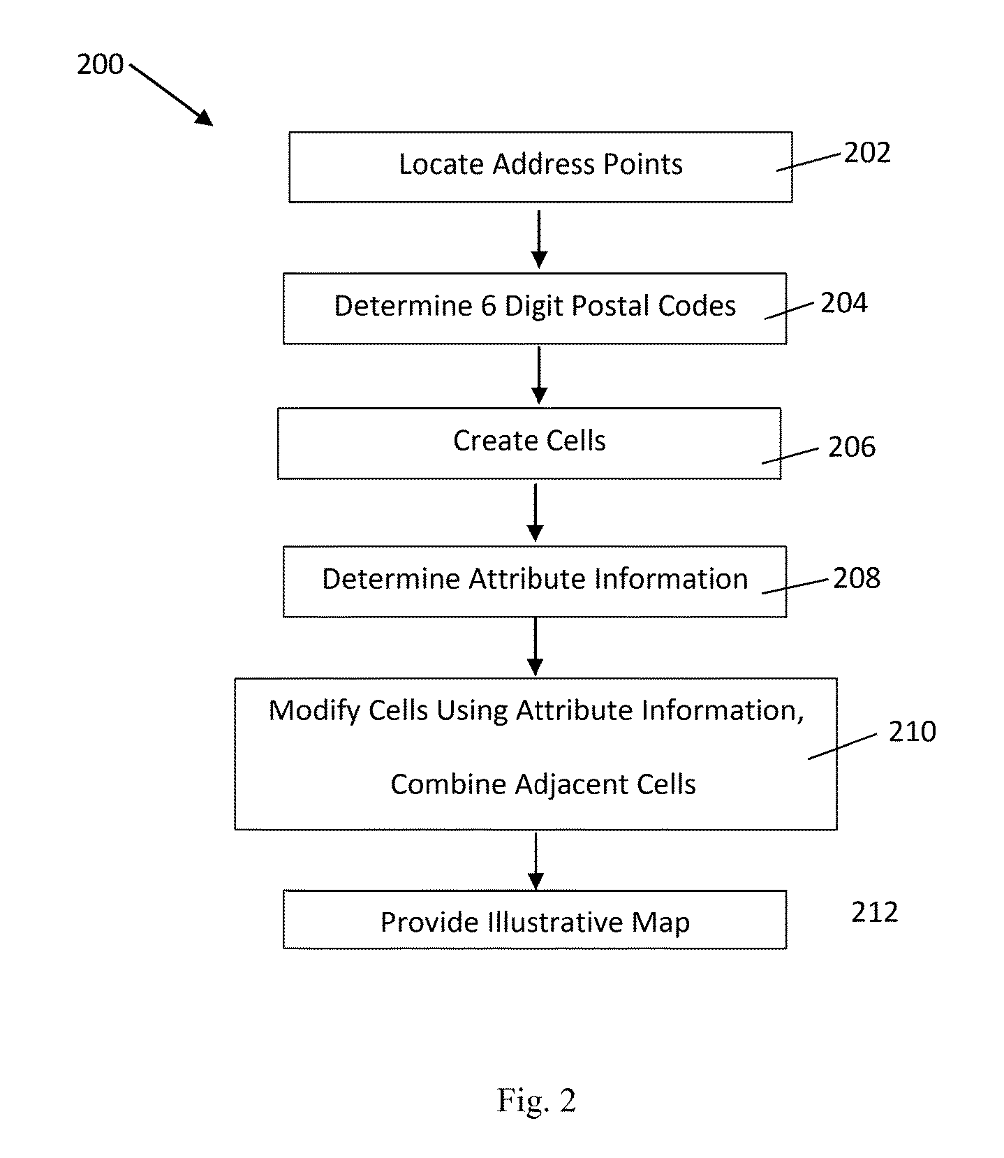
[0020]The present invention forms polygons using addresses and multiple-digit postal codes (for example, six-digit postal codes, but not limited thereto, and wherein digits can include letters, numbers, or combinations thereof) of each in both urban and rural regions, wherein such a polygon fabric representing six-digit postal codes provides more granular and precise entities to optimize activities such as trade area analysis and visualization. The present invention creates such polygons by generating Voronoi tessellation based on the location of high precision address points and / or interpolated address points, six-digit postal codes of each and, for further refinement, uses attribution information and / or other spatial features such as streets, roads and highways; water borders or boundaries; rail lines; and park, city, county and other municipal, commercial or residential boundaries or barriers to further enclose, restrict and / or define the resulting polygon limits.

[0021]To do so, ...


PUM


Abstract

A postal code map and related data constructed of polygons representing multiple-digit postal codes and defined by attribution information and/or other spatial features thereby providing more granular and precise entities to optimize activities such as trade area analysis and visualization. The polygons are created and illustrated by generating Voronoi tessellation based on the location of high precision address points and/or interpolated address points, multiple-digit postal codes of each and, for further refinement, attribution information and/or other spatial features such as streets, roads and highways; water borders and boundaries; rail lines; and park, city, county and other municipal, commercial and residential boundaries or barriers to further enclose, restrict and/or define the resulting polygon limits of the visual map.

Description

BACKGROUND[0001]A number of postal mapping techniques currently exist for various uses and applications across a range of countries. For example, in the United States, there are postal mapping techniques ranging from simple ZIP code maps to more detailed usage and data maps. The accuracy and applicability of these maps can vary depending on formation parameters, and associated rules and regulations of the postal authorities for a given area. Accuracy and applicability of such maps is important, since confusion may have significant implications. For example, mail volume is one factor used by the U.S. Census Bureau to estimate population changes. In this case, the U.S. Census Bureau calculates approximate boundaries of ZIP codes areas using ZIP Code Tabulation Areas (ZCTAs), and census data is provided for the tabulated areas. Still another common use of postal mapping is in marketing or more specifically, direct mail marketing campaigns using postal mapping techniques such as Voronoi...

Claims


Application Information

Patent Timeline
Patent Type & Authority Applications(United States)
IPC IPC(8): G06Q30/02G06Q50/32
CPCG06Q30/0201G06Q10/08G06Q50/32
Inventor POWELL, PETER O.
Owner DMTI SPATIAL INC
Why Eureka
Try Eureka