Dynamic modeling of geospatial words in social media

a geospatial word and dynamic modeling technology, applied in the field of computer applications, can solve problems such as capture the temporal varian

Active Publication Date: 2016-11-17
AIRBNB
View PDF0 Cites 1 Cited by
  • Summary
  • Abstract
  • Description
  • Claims
  • Application Information

AI Technical Summary

Problems solved by technology

Existing geotagging models are often trained in an off-line manner, and this implies these models do not capture the temporal variance of geospatial words, when time-invariant geospatial words are persistently associated with a location, while other words are only temporarily associated with a location.

Method used


Image

  • Dynamic modeling of geospatial words in social media
  • Dynamic modeling of geospatial words in social media
  • Dynamic modeling of geospatial words in social media

Examples


Embodiment Construction

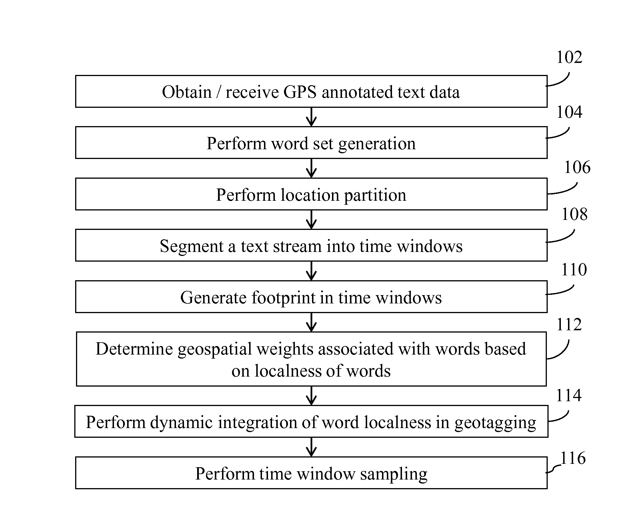
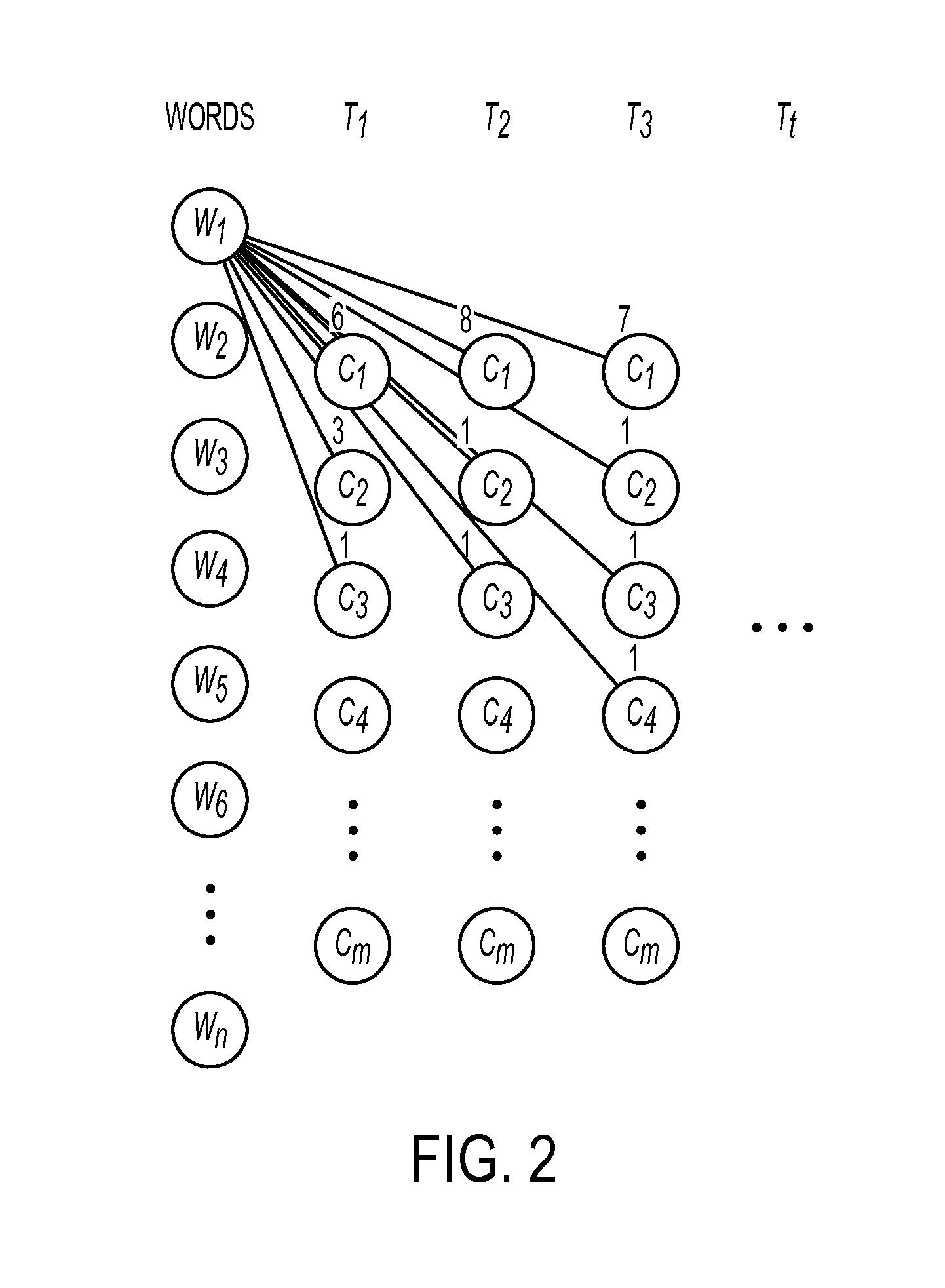
[0012]A method and system are presented that leverage location indicative words to determine location. The method and system for example may offset the temporal variance in geospatial word modelling by dynamically weighting word localness scores in social media text stream. A dynamic geospatial word modelling technique in one embodiment keeps geotagging models up-to-date. In one aspect, the techniques keep the models up-to-date with only fixed computational cost. In one embodiment, randomized methods may be applied to generate consecutive location footprints for each word over time. Word localness scores are calculated based on these footprints. In one embodiment, the overall word localness can be incrementally updated with only fixed computational cost. A discriminative model in one embodiment then seamlessly incorporates updated localness scores in geotagging. As a result, the geotagging model is kept up-to-date without re-training the model on all historical data. Such an approac...


PUM


Abstract

Dynamically modelling geospatial words in social media, in one aspect, generates a word set based on frequencies of words occurring in GPS annotated text data generated by a GPS-enabled device containing latitude and longitude coordinates. Locations are partitioned by mapping GPS coordinates in the GPS annotated text data to a set of discrete non-overlapped locations. A text stream contained in the GPS annotated text data is segmented into time windows. Footprints of locations in time windows are generated. Geospatial weights associated with words in the word set are generated based on localness of words determined based on the footprints. Words in a text message are extracted and scores are determined for the set of discrete non-overlapped locations associated with the words.

Description

FIELD[0001]The present application relates generally to computers and computer applications, and more particularly to dynamic modelling of geospatial words in social media.BACKGROUND[0002]Geospatial information is useful to a number of applications, such as targeted advertising, regional sentiment analysis and situational awareness. Due to a lack of sufficient and reliable geographical information in social media (e.g., Internet Protocol (IP) addresses mapped to locations), various geotagging methods have been utilized to infer geographical location based on text data. Such geotagging methods leverage location indicative words to determine location. For instance, by knowing local sports event footy and a local transportation tram, the most probable location inferred is City X, Country Y, because these words together are mostly used by City X residents.[0003]Streaming text data in social media is dynamic, i.e., its content and topics change rapidly, making geotagging a non-trivial ta...

Claims


Application Information

Patent Timeline
Patent Type & Authority Applications(United States)
IPC IPC(8): G06F17/24G06F17/27G06F40/00
CPCG06F17/241G06F17/271G06F17/278G06F16/9537G06F16/35G06F40/263G06F40/279G06F40/169G06F40/211G06F40/295
Inventor BUTLER, CHRISTOPHER J.HAN, BOLAI, JENNIFER C.
Owner AIRBNB
Why Eureka
Try Eureka