Regional geospatial data fusion method

A technology of geospatial data and fusion method, which is applied in the direction of geographic information database, relational database, database model, etc., can solve the problems of lack of versatility, achieve the effect of improving the quality of geospatial data, speeding up the update speed, and reducing production costs

Inactive Publication Date: 2018-07-20
GUANGZHOU INST OF GEOGRAPHY GUANGDONG ACAD OF SCI
View PDF3 Cites 12 Cited by
  • Summary
  • Abstract
  • Description
  • Claims
  • Application Information

AI Technical Summary

Problems solved by technology

Domestic fusion of geospatial vector data often only focuses on certain aspects, or uses specific methods to solve specific problems for a specific need, but these methods are not universal

Method used


Image

  • Regional geospatial data fusion method
  • Regional geospatial data fusion method
  • Regional geospatial data fusion method

Examples


Embodiment Construction

[0025] The technical solution of this patent will be further described in detail below in conjunction with specific embodiments.

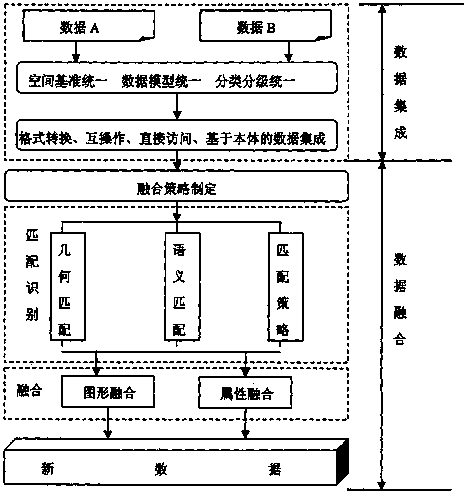
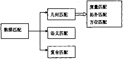
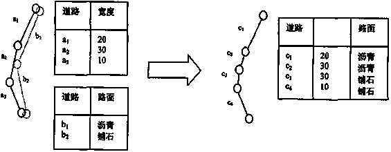
[0026] see Figure 1-3 , a regional geospatial data fusion method, comprising the following steps:

[0027] 1. The selection principles of geospatial elements;

[0028] Space vector data from different sources in the same area should be comprehensively selected when it comes to the repeated representation of the same elements; generally there are the following principles: the principle of uniqueness, the principle of geometric accuracy, the principle of current situation, the principle of suitable scale, the principle of the same coordinate system, etc. , but sometimes in order to highlight a certain theme element, or to meet a certain need, it should be comprehensively selected according to the specific situation;

[0029] (1) The principle of uniqueness: in multi-source data, if only one data source has the required geographic information data,...


PUM


Abstract

The invention discloses a regional geospatial data fusion method. The method comprises the following steps that 1, geospatial element selecting principles comprise a unique principle, a geometric accuracy principle, a currency principle, a measuring scale suitable principle and a coordinate system same principle; 2, geospatial vector data is integrated; 3, the geospatial vector data is fused; (1)identical entities are matched and identified; (2) geometric positions of the geospatial vector data are fused; (3) attributes of the geospatial vector data are fused. The geospatial vector data fusion study extracts required information from the geospatial vector data with different data sources, different data precision and different data models, according to new application requirements of a user, new spatial data is constructed, not only can the production cost of geographic data be reduced, the upgrade speed of existing geographic information is accelerated, but also it is of great significance to improve the quality of the geospatial data.

Description

technical field [0001] The invention relates to a fusion method, in particular to a regional geospatial data fusion method. Background technique [0002] Related to the research content of geospatial vector data fusion is map merging. The earliest map merging in the GIS environment began in the mid-1980s. In order to improve the data quality of the two departments, eliminate errors, and exchange attribute and entity information, the US Geological Survey (USGS) and the United States Census Bureau cooperated in the research of map merging technology, and successfully developed the world's first automatic merging system for map drawing, after which many scholars conducted corresponding research. Cobb and others discussed the merging technology between the American vector data standard format file VPF, and Walter and Fritsch studied the merging technology of the European geographic data file GDF and the German topographic map spatial database ATKIS, focusing on the matching of r...

Claims


Application Information

Patent Timeline
IPC IPC(8): G06F17/30
CPCG06F16/212G06F16/288G06F16/29
Inventor 张豫袁少雄陈彩霞刘峰张鹏飞黄光庆
Owner GUANGZHOU INST OF GEOGRAPHY GUANGDONG ACAD OF SCI
Why Eureka
Try Eureka