Geospatial and temporal data system

a geospatial and temporal data technology, applied in the field of geospatial and temporal data systems, can solve the problems of large amount of historical data being essentially lost or not readily available, and achieve the effect of reducing the number of historical data los

Active Publication Date: 2017-09-12
DORIS MAVIS
View PDF7 Cites 0 Cited by
  • Summary
  • Abstract
  • Description
  • Claims
  • Application Information

AI Technical Summary

Problems solved by technology

Unfortunately a large amount of historical data has been essentially lost or not readily available because it is not easily associated with general areas of interest.

Method used


Image

  • Geospatial and temporal data system
  • Geospatial and temporal data system

Examples


Embodiment Construction

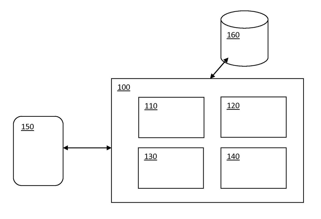
[0009]Embodiments of the present invention include systems and methods that provide historic data based on Z-axis temporal coordinates and / or geospatial coordinates. A system is described that associates historical data with geospatial coordinates to enable systems and methods in which the historical data can be accessed based on a defined set of geospatial coordinate(s). The Z-axis temporal coordinates can be selected in varying degrees of time granularity or period. Likewise, the historic data can be filtered based upon numerous criterions, such as subject matter. A defined set of geospatial coordinates can be one specific geospatial coordinate, a series of geospatial coordinates, a defined geospatial radius or selectable geographic region, such as a city. The historic data for neighboring geospatial coordinates within the defined set of geospatial coordinates is accessed together.

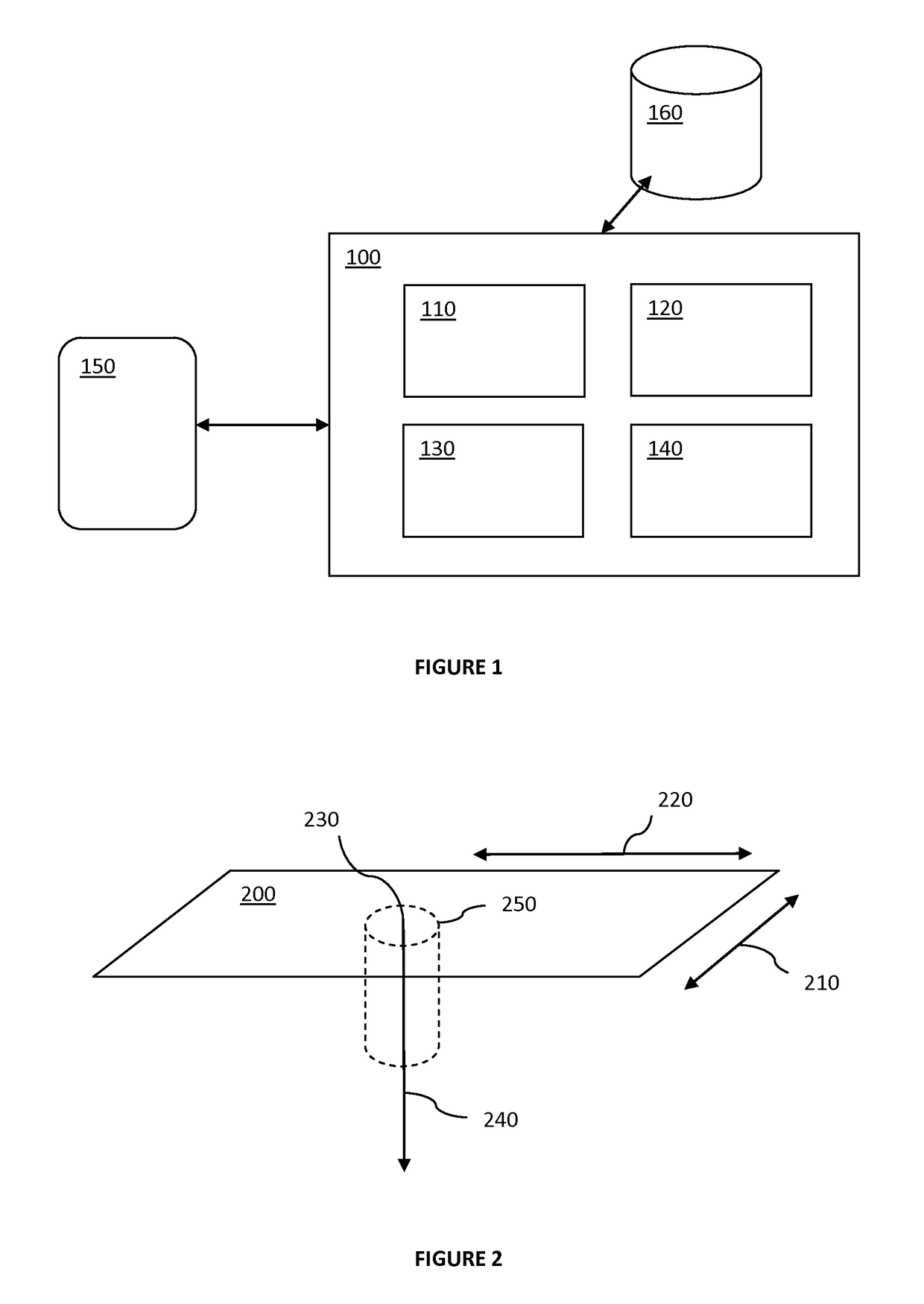
[0010]The geospatial coordinate system is basically an X-Y axis system using latitude and longitude. ...


PUM


Abstract

A system is described that a geospatial coordinate component arranged to identify a set of geospatial coordinates from a geospatial dataset. A temporal coordinate component is arranged to identify a set of temporal coordinates from a temporal dataset. The system includes an article query component that is arranged to determine a set of articles based on the set of geospatial coordinates and the set of temporal coordinates. A presentation component is arranged to present a representation of a member of the set of articles. The geospatial coordinate component can receive a user selected geographical area and intersect the geospatial dataset with the geographical area.

Description

[0001]This application claims priority to pending U.S. application Ser. No. 13 / 794,056 filed Mar. 11, 2013.BACKGROUND OF THE INVENTION[0002]Global geospatial coordinate formats are well known and heavily used to identify a global position. The Global Positioning System (GPS) is a space-based satellite navigation system that provides location anywhere on or near the Earth where there is an unobstructed line of sight to GPS satellites. The system provides critical capabilities to military, civil and commercial users around the world. It is maintained by the United States government and is freely accessible to anyone with a GPS receiver.[0003]The ability to accurately determine a location relative to known global positioning coordinates enables access to relative information such as mapping and business locations. For example, mobile mapping global positioning systems display current location relative to street maps, suggest a route to a destination, calculate a time of arrival and all...

Claims


Application Information

Patent Timeline
Patent Type & Authority Patents(United States)
IPC IPC(8): G06F7/00G06F17/30
CPCG06F17/30241G06F17/3087G06F16/29G06F16/9537
Inventor SLIFER, RUSSELL D.
Owner DORIS MAVIS
Why Eureka
Try Eureka