Methods and apparatus for performing enhanced queries for items such as maps and geospatial data

a geospatial data and enhanced query technology, applied in the field of automatic systems and methods for cataloguing, ranking and/or retrieving items, can solve the problems of not being able to retrieve the map of interest or being buried in a large collection of less-relevant maps

Inactive Publication Date: 2014-08-05
GOLDSTREAM PUBLISHING
View PDF15 Cites 2 Cited by
  • Summary
  • Abstract
  • Description
  • Claims
  • Application Information

AI Technical Summary

Problems solved by technology

Both of these approaches have significant limitations that may result in a map of interest not being retrieved or being buried in a large collection of less-relevant maps.
Similar issues occur when attempting to locate other items that are associated with locations.

Method used


Image

  • Methods and apparatus for performing enhanced queries for items such as maps and geospatial data
  • Methods and apparatus for performing enhanced queries for items such as maps and geospatial data
  • Methods and apparatus for performing enhanced queries for items such as maps and geospatial data

Examples


Embodiment Construction

s

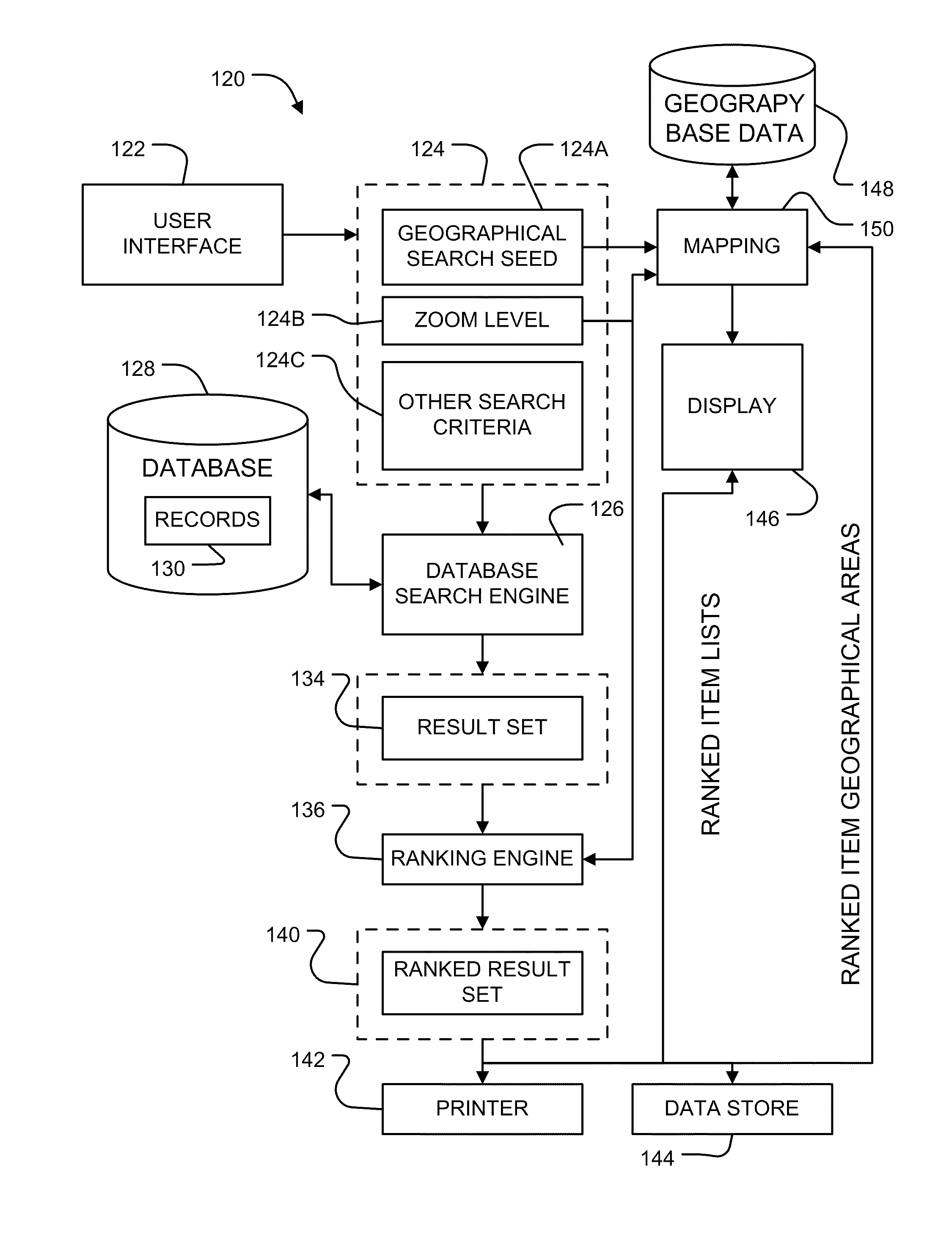
[0184]Technology as described herein may be applied to catalogue and organize an inventory of maps. For example, the technology may be applied to allow users to select maps for viewing and / or purchase. The technology may be provided in a system having a web-based front end to receive search requests and provide search results. Locally based advertising may be provided as the search technology enables advertisers to target users who are searching for information for a specific geographic area. FIG. 16 illustrates how map search technology as described herein may be integrated into a map store, providing an easy way to find and purchase maps and geospatial data. FIG. 16A illustrates another example embodiment.

[0185]System 120 has a user input 122 that a user can use to generate search criteria 124 comprising a search seed 124A and optionally a zoom level 124B and other search criteria 124C. A search engine 126 executes searches against a database 128 containing records 130 relating t...


PUM


Abstract

Methods and apparatus for cataloguing items such as maps and geospatial data sets store in a database information defining a geospatial region corresponding to each item and a size characteristic of the geospatial area. The database may be queried to identify items of interest by intersecting a search seed comprising one or more geospatial points lines or areas with the areas corresponding to the items. A result set containing items produced by a query may be ordered at least in part according to the size characteristics. In some embodiments the size characteristics comprise square roots of the areas of the geospatial regions.

Description

CROSS-REFERENCE TO RELATED APPLICATION[0001]This application claims the benefit under 35 U.S.C. §119 of U.S. application No. 61 / 295,026 filed on 14 Jan. 2010 and entitled METHODS AND APPARATUS FOR PERFORMING ENHANCED QUERIES FOR ITEMS SUCH AS MAPS AND GEOSPATIAL DATA which is hereby incorporated herein by reference for all purposes as if fully set forth herein.TECHNICAL FIELD[0002]The invention relates to automated systems and methods for cataloguing, ranking and / or retrieving items that are associated with locations. In some example applications the items comprise maps and / or geospatial data sets.BACKGROUND[0003]Items such as maps are increasingly catalogued in electronic databases. In addition, more and more maps are becoming available. There is a need for apparatus and methods for locating maps of interest from among the maps included in large collections. Current approaches for searching for maps of interest include text-based searches and map-based searches. Both of these appro...

Claims


Application Information

Patent Timeline
Patent Type & Authority Patents(United States)
IPC IPC(8): G06F17/30G06Q30/02
CPCG06F17/30241G06Q30/00G06Q30/0251G06F16/29
Inventor SIMMONS, SEAN
Owner GOLDSTREAM PUBLISHING
Why Eureka
Try Eureka