Check patentability & draft patents in minutes with Patsnap Eureka AI!

System and methodology for activating geofence from selection list

Active Publication Date: 2018-05-17
KYNDRYL INC
View PDF8 Cites 3 Cited by
  • Summary
  • Abstract
  • Description
  • Claims
  • Application Information

AI Technical Summary

Benefits of technology

The patent describes a computer system and method for activating and deactivating geofences based on data collected from analytics, calendaring, and on-demand sources. The system allows users to define geofences and activate them based on certain rules and conditions. The technical effect is providing a more efficient and effective way to manage geofternals and track movement in real-time.

Problems solved by technology

Known methods and systems that utilize geofences can create and monitor them according to input from a user but cannot select what geofence should be used based on a specified schedule.

Method used


Image

  • System and methodology for activating geofence from selection list
  • System and methodology for activating geofence from selection list
  • System and methodology for activating geofence from selection list

Examples


Embodiment Construction

[0013]Embodiments of the present invention recognize that typically, a geofence is generated by a radius around a point location or a target area such as a store, generated as pre-determined distance from a road, or as a geofence boundary on a map such as a park boundary determined using map coordinates or geographic coordinates.

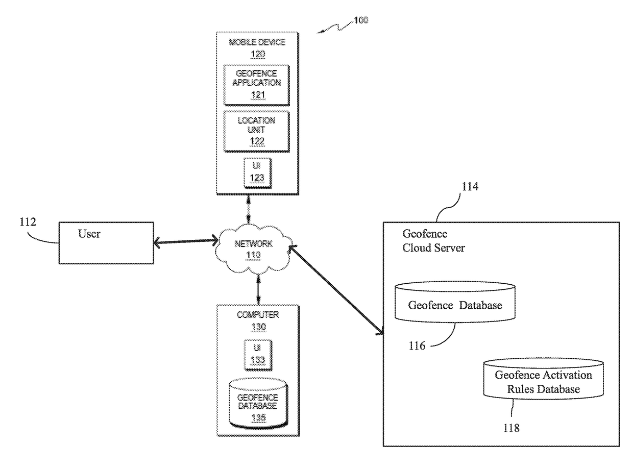
[0014]FIG. 1 is a functional block diagram illustrating a distributed data processing environment, generally designated 100, in accordance with at least one embodiment of the present invention. FIG. 1 provides only an illustration of one implementation and does not imply any limitations with regard to the environments in which different embodiments may be implemented. Many modifications to the depicted environment may be made by those skilled in the art without departing from the scope of the invention as recited by the claims.

[0015]As depicted, distributed data processing environment 100 includes mobile device 120, computer 130, a user 112 and a geofence se...


PUM


Abstract

The disclosure is directed to methods and systems for activating a geofence. These methods and systems include storing a plurality of pre-defined geofences in a database, storing a plurality of geofence activation rules in a database, each activation rule being based on data obtained from at least one member selected from the group consisting of analytics data, calendaring data and on-demand data, enable a geofence activation rule, selecting at least one pre-defined geofence based on the enabled geofence activation rule and activating and deactivating the at least one selected pre-defined geofence based on the enabled a geofence activation rule.

Description

FIELD[0001]The present application relates generally to computers, and computer applications, and more particularly to computer-implemented methods to activate one or more geofences from a list of geofences.BACKGROUND[0002]A geofence is a virtual perimeter or a virtual boundary for a geographic area. A geofence is commonly used with a location-aware device (e.g., a mobile device or a wearable computing device) that is using a location-based service (LBS) such as a global positioning system (GPS) to determine if a user is entering or exiting a geofenced area. When a user carrying a location aware device crosses a geofence boundary, an alert and / or notification may be sent to the location aware device (e.g., a mobile device or a wearable computing device) user as well as generating a message to the geofence operator who sets up and / or maintains the geofence.[0003]Known methods and systems that utilize geofences can create and monitor them according to input from a user but cannot sele...

Claims


Application Information

Patent Timeline
IPC IPC(8): H04W4/02
CPCH04W4/025H04W4/021
Inventor ANDERSON, EVELYN R.BENDER, MICHAELCHILDRESS, RHONDA L.
Owner KYNDRYL INC
Features
  • R&D
  • Intellectual Property
  • Life Sciences
  • Materials
  • Tech Scout
  • Unparalleled Data Quality
  • Higher Quality Content
  • 60% Fewer Hallucinations
Learn More