Portable map display system for presenting a 3D map image and method thereof

a display system and map technology, applied in traffic control systems, navigation instruments, instruments, etc., can solve the problems of inconvenient carrying, repeated folding and unfolding, and user that is navigating an unknown city on foot still has many problems, and achieves the effect of up-to-date printed maps, convenient carrying and awkward folding and unfolding

Inactive Publication Date: 2002-09-17
NOKIA TECHNOLOGLES OY
View PDF8 Cites 252 Cited by
  • Summary
  • Abstract
  • Description
  • Claims
  • Application Information

AI Technical Summary

Benefits of technology

Another object of the present invention is to provide a system and method for a portable map display device where the scale and resolution of the displayed map image clearly depict the user's spatial relationship with the objects shown in the displayed map image.
Another object of the present invention is to provide a system and method for a portable map display device which does not interfere with the walking, or walking tourist, experience.

Problems solved by technology

Although the past twenty years has seen rapid advances in the art of global positioning and dynamic map generation, a user that is navigating an unknown city on foot is still burdened with many problems.
For instance, traditional paper maps, which are still the dominant navigational tool for walking tourists, are inconvenient to carry and awkward to repeatedly fold and unfold.
Furthermore, the user must first locate his or her position on the map, a task that is not always simple, in order to successfully navigate to another location.
There is also the problem of the printed map being up-to-date, and showing the information that is relevant to the particular user viewing the map.
These electronic maps do solve the problem of showing both the user's current location and a map of the surrounding environment, but they have their own problems.
First, obviously, the GPS systems embedded in some cars is of no use to a walking tourist.
Second, when using such a portable device, there is the problem of the scale and resolution of the map image.
Both of these factors lead to the user being unable to directly relate the displayed information with the objects and sights around him or her.
However, because of the limitations of a hand-held device, this problem is difficult to resolve.
If the resolution of the small display screen is increased, the user will be unable to see the details because of the small size of the screen.
If the size of the screen is increased, the size of the hand-held instrument will become larger, and, thus, more difficult to carry.
Furthermore, when hand-held devices are used, it is somewhat disruptive of the walking and / or walking tourist experience.
However, continually lifting this device up to the sunlight in order to determine one's location, or to determine the location of nearby sites, would be a hindrance.
Particularly if one could not find an adequate light source.
Furthermore, this device provides no information concerning local sites, eating establishments, etc.

Method used


Image

  • Portable map display system for presenting a 3D map image and method thereof
  • Portable map display system for presenting a 3D map image and method thereof
  • Portable map display system for presenting a 3D map image and method thereof

Examples


Embodiment Construction

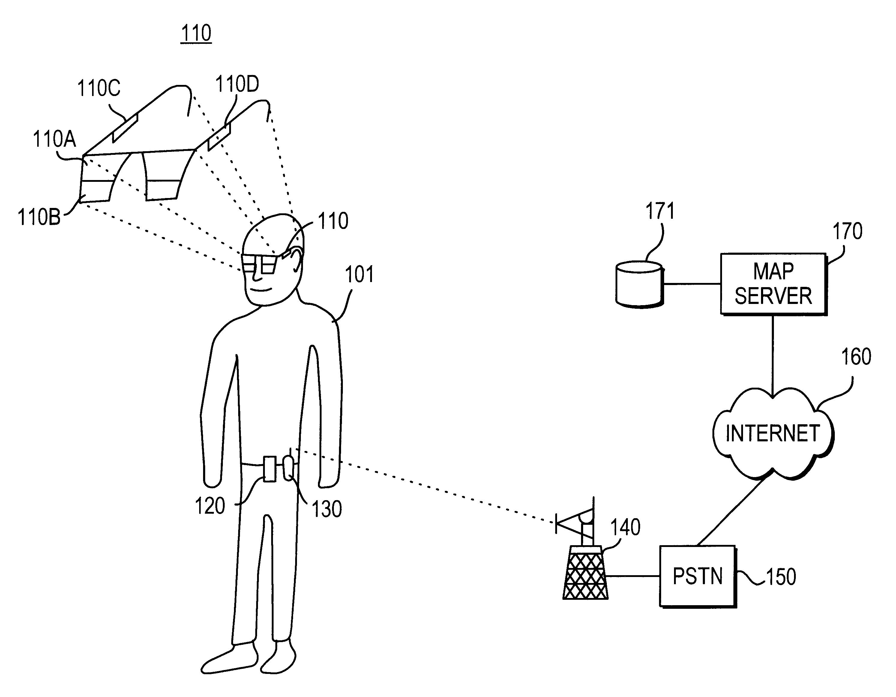
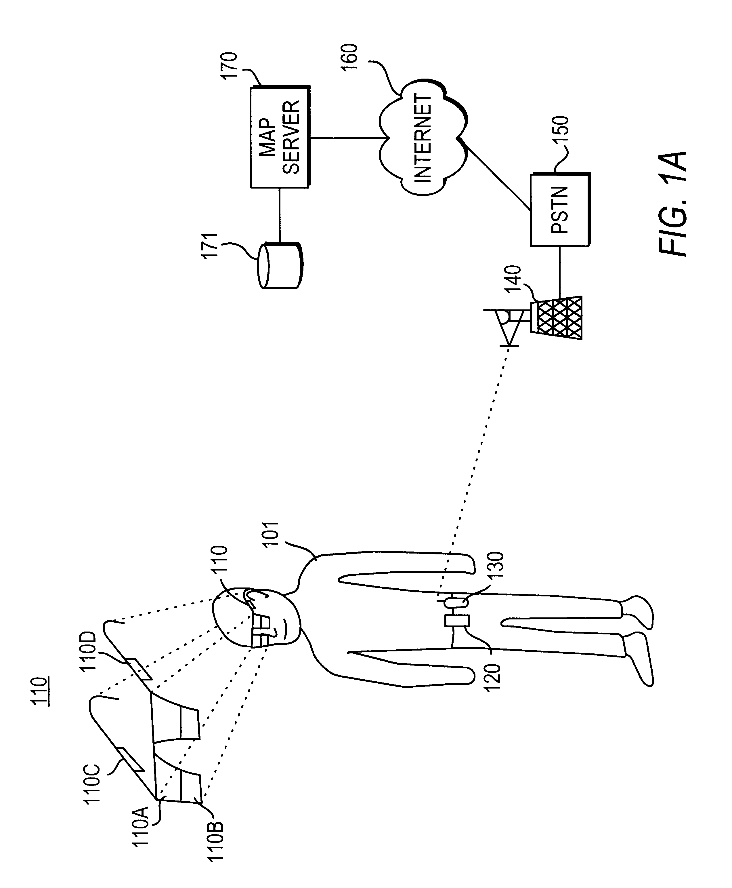
To overcome limitations in the prior art described above, and to overcome other limitations that will be apparent upon reading and understanding the present specification, the present invention is a system and method for providing and displaying vector map data in a portable display, preferably a head-worn display.

In the presently preferred embodiment, the user is equipped with a head-worn display, in which the viewing section is separated into two portions, a lower portion which operates as a display screen, and an upper portion, which is transparent so that the user may observe the environment around him or her. In the presently preferred embodiment, the viewing section is completely see-through and the display ("lower portion") can be superimposed on any, or all, of the see-through lenses. Sensors and GPS data, which locate the position of the user, as well as the relative orientation of the glasses, enable the display screen to display a map corresponding to what the user sees i...


PUM


Abstract

A system and method for displaying map data to a person using either a hand-held or head-worn display is described. In one preferred system, a head-worn display is used. The location of the person and the direction of the person's view is determined. A map image indicated by the location and direction is presented in the display. This map image is displayed in a three-dimensional perspective view, allowing the person to easily associate the objects in the map image with the real objects in the person's field of view. In addition, the user may indicate a desired destination and the three-dimensional perspective view will be changed according to the user's location relative to the desired destination.

Description

1. Field of the InventionThis invention relates to a system and method for providing and displaying map information, including a perspective map, on a portable map display, and in particular a head-worn display.2. Description of the Related ArtAlthough the past twenty years has seen rapid advances in the art of global positioning and dynamic map generation, a user that is navigating an unknown city on foot is still burdened with many problems. For instance, traditional paper maps, which are still the dominant navigational tool for walking tourists, are inconvenient to carry and awkward to repeatedly fold and unfold. Furthermore, the user must first locate his or her position on the map, a task that is not always simple, in order to successfully navigate to another location. There is also the problem of the printed map being up-to-date, and showing the information that is relevant to the particular user viewing the map. In addition, the user may want additional information, which can...

Claims


Application Information

Patent Timeline
Patent Type & Authority Patents(United States)
IPC IPC(8): G01C21/36G01C21/34G09B29/10G01S19/48
CPCG01C21/20G01C21/3635G09B29/10
Inventor HAKALA, TEROLEHIKOINEN, JUHASUOMELA, RIKUROYKKEE, MIKA
Owner NOKIA TECHNOLOGLES OY
Why Eureka
Try Eureka