
Navigation system, route searching method, and map information guide method

a navigation system and route technology, applied in the field of navigation systems, can solve the problems of user inability to advance the mobile unit, user inability to understand, and the processing of determining the presence or absence of restrictions on each restriction road becomes very complicated, so as to guide the user quickly and reliably

Inactive Publication Date: 2005-09-20
MITSUBISHI ELECTRIC CORP
View PDF8 Cites 10 Cited by
  • Summary
  • Abstract
  • Description
  • Claims
  • Application Information

AI Technical Summary

Benefits of technology

[0013]It is therefore an object of the invention to provide a navigation system that can guide the user rapidly and reliably through an optimum route considering the restriction time period of a time restriction road in both an urban area and a suburban area.
[0014]It is another object of the invention to provide a navigation system for enabling the user to easily recognize the time relation between the restriction time period of a time restriction road and the current time.

Problems solved by technology

Thus, the navigation system guides the user through a route taking a long way to avoid an essentially passable road or guides the user through an essentially impassable road and when the mobile unit is about to reach a time restriction road, the user cannot advance the mobile unit because of the time restriction, etc.
; this is a problem.
Although a run route to bypass a time restriction road is displayed, the user cannot understand why the route presented on the display screen indicates a bypass taking a long way; this is a problem.
Further, if the user makes a determination as to which route to select and drives while seeing a map displayed on the display screen without setting a route, although time restriction information exists, it is not displayed on the display screen and thus the user drives while being unaware of a time restriction road and suddenly encounters the time restriction road, and his or her way is blocked; this is a problem.
Thus, a search must be made for a time restriction road over a wide range more than necessary in an urban area, etc., where a large number of complicated restrictions are placed or arrival prediction times at a large number of time restriction roads are all calculated and thus processing of determining the presence or absence of restriction on each time restriction road becomes very complicated and it takes time more than necessary in searching for a route bypassing the time restriction roads; this is a problem.
In differential display of a time restriction road, the presence of the time restriction road can be recognized, but the time restriction road is not displayed in such a manner that the relationship between the restriction time period and the current time can be recognized and therefore there is a problem of taking the trouble to take a long way to bypass the passable road at the current point in time.

Method used


Image

  • Navigation system, route searching method, and map information guide method
  • Navigation system, route searching method, and map information guide method
  • Navigation system, route searching method, and map information guide method

Examples


first embodiment

(First Embodiment)

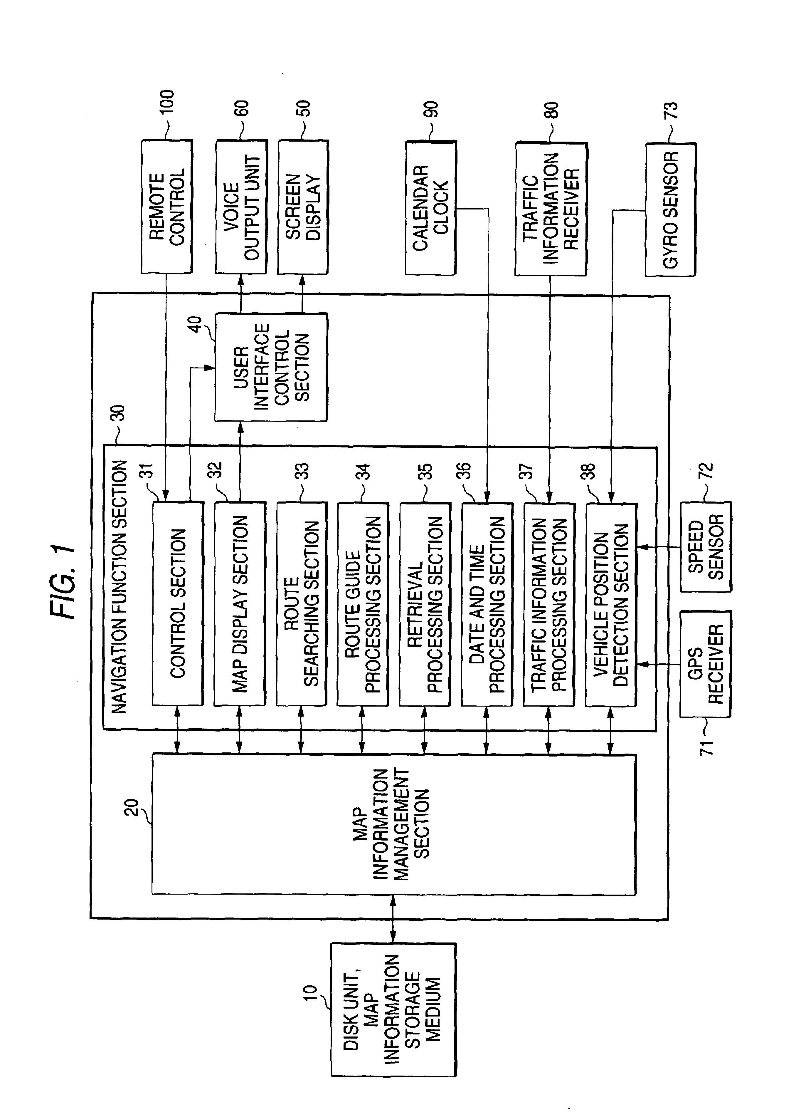
[0043]FIG. 1 is a block diagram to show the configuration of a navigation system in a first embodiment of the invention. It shows the configuration of the navigation system installed in a vehicle as a mobile unit incorporating the invention.

[0044]Numeral 10 denotes a disk unit as map information acquisition section for reading map information from an information storage medium such as a CD-ROM (compact disk-read-only memory) or a DVD-ROM (digital versatile disk-read-only memory), numeral 20 denotes a map information management section for managing read map information, and numeral 30 denotes a navigation function section for providing various navigation functions based on the map information. Numeral 40 denotes a user interface control section for controlling output of display information and voice information of a map image, a guide voice, etc., numeral 50 denotes a screen display such as a liquid crystal display for outputting display information, and numeral 60 ...

second embodiment

(Second Embodiment)

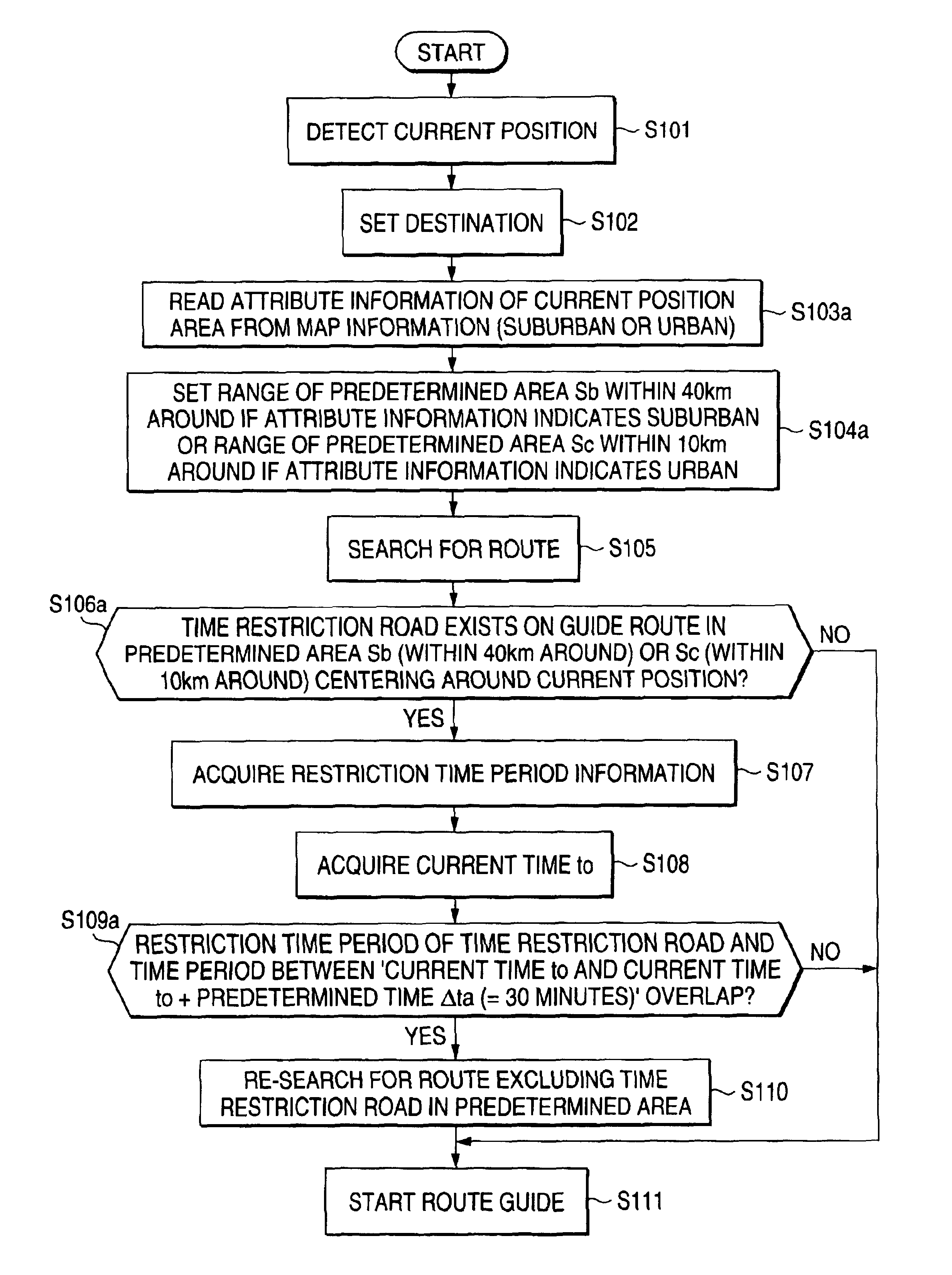
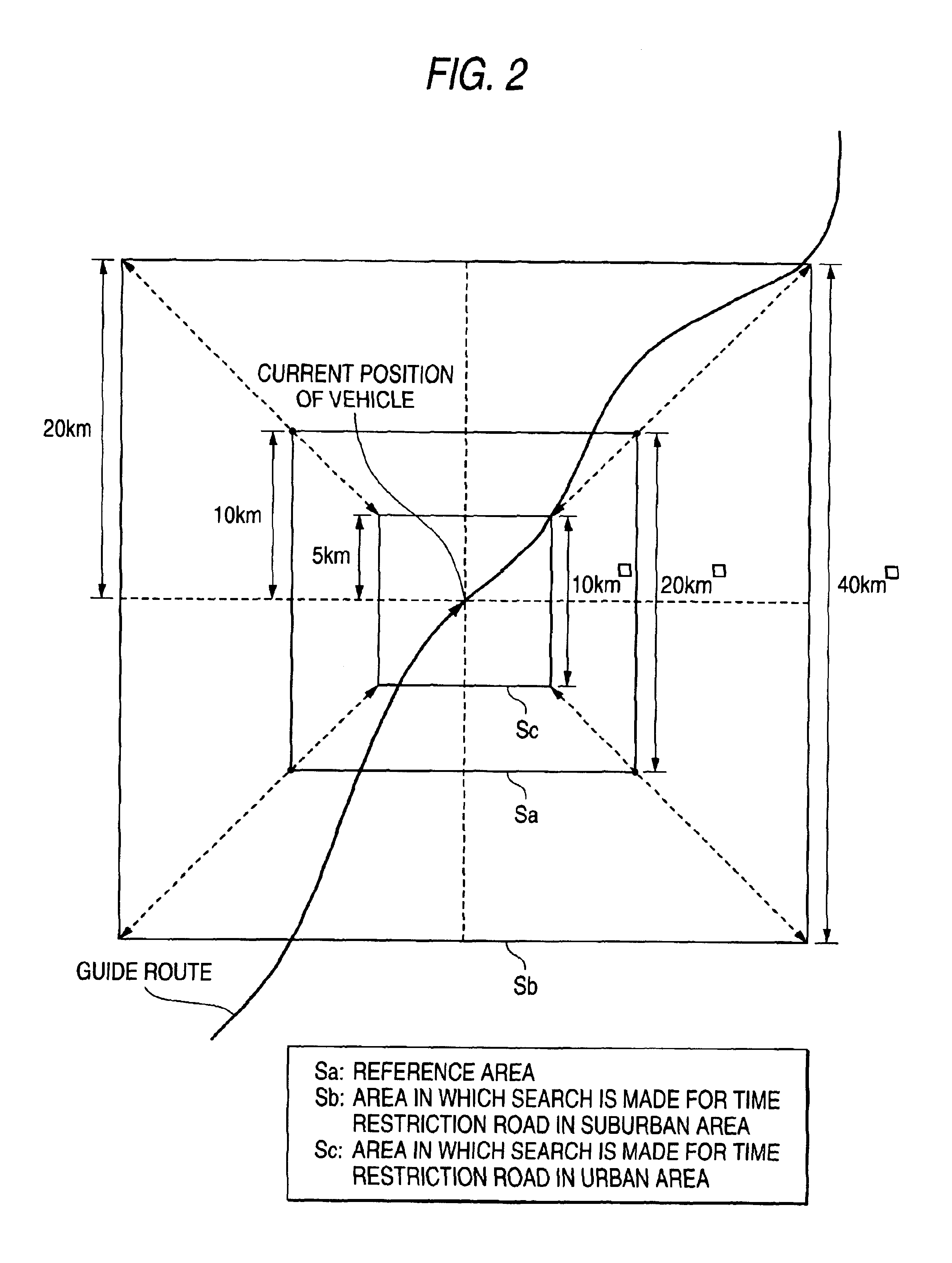
[0079]Next, as a second embodiment of the invention, an example will be discussed wherein the range S in which the route searching section 33 in FIG. 1 searches for a time restriction road is made constant and the value of predetermined time Δt to be added to current time to when the restriction time period of a time restriction road overlap is determined is changed depending on whether the area is a suburban or urban area.

[0080]FIGS. 5 to 7 are schematic drawings to describe the range searching for a time restriction road and the passage prediction time period through the time restriction road in the second embodiment. In the first embodiment, attention is focused on the difference between the vehicle run ranges S in a suburban area and an urban area in the predetermined time Δt; while, in the second embodiment, attention is focused on the difference between required time Δt for a vehicle to run in a suburban area and that in an urban area in reference area Sa. T...

third embodiment

(Third Embodiment)

[0107]In the first and second embodiments, map information stored on the map information storage medium is provided with “suburban / urban area” information as attribute information of each zone and the “suburban / urban area” information is referenced for determining whether the area of the current position of the vehicle is a suburban area or an urban area. In a third embodiment of the invention, an example will be discussed wherein “suburban / urban area” information as attribute information entered by the user is referenced for determining whether the area of the current position of the vehicle is a suburban area or an urban area.

[0108]FIGS. 10 and 11 are flowcharts to show rough operation of the first route searching and rough operation of the route searching while a vehicle is running in the third embodiment. They represent examples wherein the range of a predetermined area S searching for a time restriction road is changed, as in the first embodiment, based on the...


PUM


Abstract

A route searching section 33 determines whether the area of the current position is an urban area or a suburban area, sets a predetermined area S or a predetermined time Δt responsive to the determination result, and determines the presence or absence of restriction on each time restriction road depending on whether or not a time restriction road exists in the predetermined area S centering around the current position and whether or not the restriction time period of the time restriction road overlaps the time period in the predetermined time Δt from the current time to. If the route searching section determines the presence of restriction, it searches for a route avoiding the time restriction road.

Description

BACKGROUND OF THE INVENTION[0001]This invention is pertinent to a navigation system and relates in particular to a navigation system, a route searching method, and a map information guide method for appropriately bypassing a time restriction road and searching for a route from the current position of the vehicle to a destination and guiding the driver through the route.[0002]In recent years, a navigation system for displaying the current position of a mobile unit on a map and searching for an optimum route to a destination and guiding the user through the route is developed heavily. Recently, an attempt is made to provide a navigation system for guiding the user through a bypass avoiding traffic restriction and congestion based on road traffic information, etc., thereby enabling the user to drive to the destination more smoothly.[0003]In route searching in such a navigation system, if candidates for a route found as the user sets a destination contain a time restriction road, hither...

Claims


Application Information

Patent Timeline
Patent Type & Authority Patents(United States)
IPC IPC(8): G01C21/34G01C21/00G09B29/00G08G1/0969G09B29/10
CPCG01C21/3461G01C21/3492
Inventor UOTANI, KAZUSHI
Owner MITSUBISHI ELECTRIC CORP
Learn More