
System and method for extending GPS to divers and underwater vehicles

a technology for underwater vehicles and gps navigation, applied in direction finders, instruments, acoustic wave reradiation, etc., can solve the problems of limited utility, buoys not staying in place, and underwater vehicles beneath water's surface are not able to utilize gps signals to accurately navigate between two points, etc., to achieve the effect of extending gps to underwater users

Inactive Publication Date: 2007-09-18
ESTATE OF ALBERT R BASILICO
View PDF54 Cites 27 Cited by
  • Summary
  • Abstract
  • Description
  • Claims
  • Application Information

AI Technical Summary

Problems solved by technology

Consequently, divers and underwater vehicles beneath the water's surface are not able utilize these GPS signals to accurately navigate between two points.
This solution is limited in utility by the need for a tether connecting the underwater diver or vehicle to the floating buoy.
However, the floating buoys do not stay in place, but instead drift on the surface of the water.
Further, floating buoys are subject to easy detection and thus are not suitable for covert operations.

Method used


Image

  • System and method for extending GPS to divers and underwater vehicles
  • System and method for extending GPS to divers and underwater vehicles
  • System and method for extending GPS to divers and underwater vehicles

Examples


Embodiment Construction

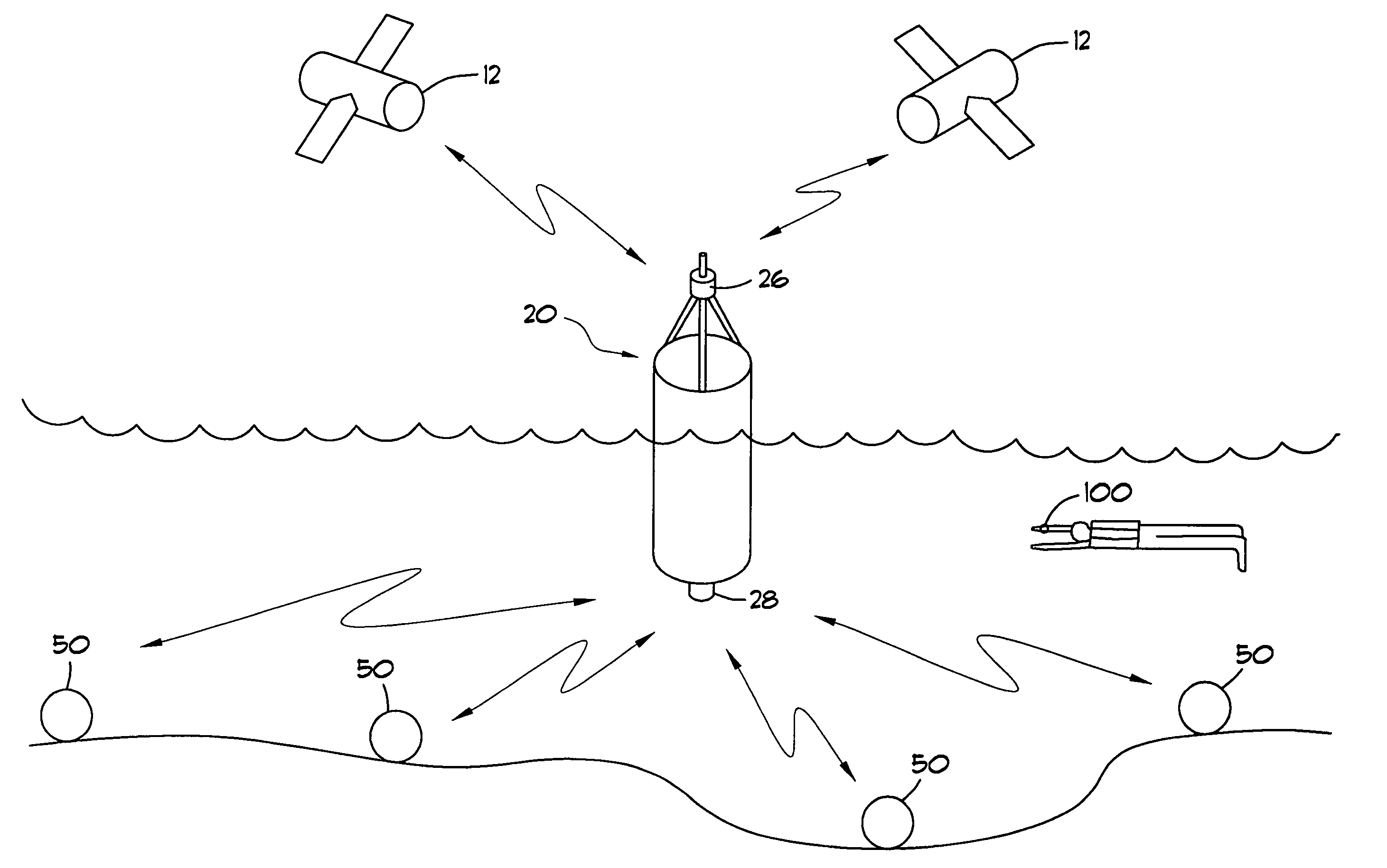
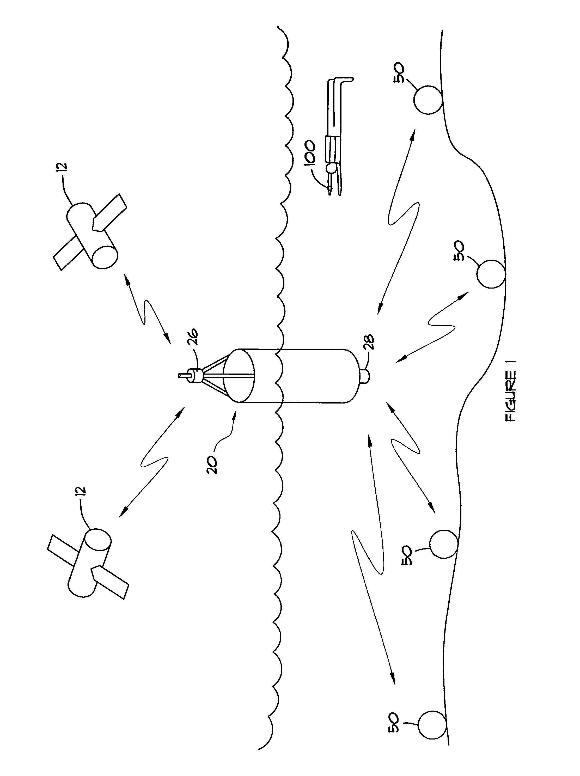
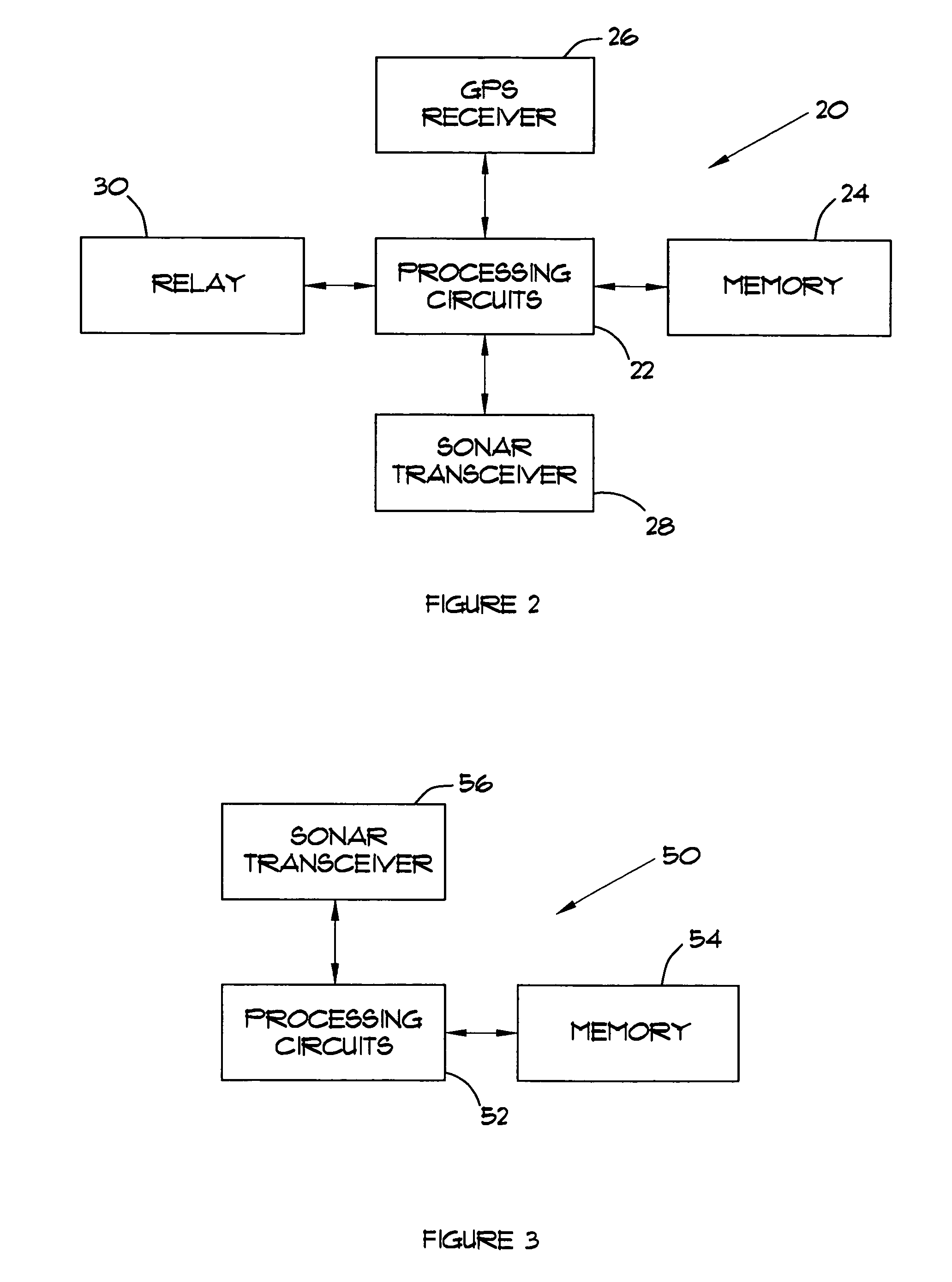
[0012]Referring now to the drawings, FIG. 1 illustrates an underwater navigation system 10 to provide navigation assistance to a diver or underwater vehicle. The underwater navigation system 10 comprises at least one surface unit 20 that communicates with earth-orbiting satellites 12 and a plurality of beacon units 50 located beneath the water's surface that communicate with the surface unit 20. The surface unit 20 includes a GPS receiver 26 for receiving GPS signals from GPS satellites 12. The surface 20 communicates with the sub-surface beacon units 50 using acoustic signals.

[0013]The beacon units 50 and surface unit 20 are dropped in an area where navigation assistance is needed. The beacon units 50 are designed to sink immediately to the ocean floor. The surface unit 20 floats on the surface long enough for the beacon units 50 to determine its positions as hereinafter described and then sinks to the bottom. While the surface unit 20 is floating on the surface, it receives GPS si...


PUM


Abstract

A navigation system extends satellite navigation to divers. The navigation system comprises a surface unit and a plurality of sub-surface beacon units. The surface unit includes a receiver to receive navigation signals from earth-orbiting satellites, processing circuits to communicate with to sub-surface beacon units and to transmit location information to said sub-surface beacon units, and a sonar transmitter to transmit location information to the sub-surface beacon units. The beacon units include a processing circuits to determine the location of the beacon unit based on location information received from the surface unit, and a sonar transceiver to receive location information from the surface unit while the surface unit is floating on the surface; and to transmit location information to a diver unit to provide navigation assistance to the diver unit.

Description

BACKGROUND OF THE INVENTION[0001]The present invention relates generally to underwater navigational and, more particularly, to a method and apparatus for extending GPS navigation to divers and underwater vehicles.[0002]Satellite-based positioning systems, such as the Global Positioning System (GPS), provide the ability to accurately determine location virtually almost anywhere on the Earth's surface. The GPS comprises 24 earth-orbiting satellites located in 6 orbital planes. Each earth-orbiting satellite carries an atomic clock and continuously broadcasts radio signals indicating its current time and location. A receiver located on the Earth's surface can receive these radio signals and determine its distance from the satellites based on the time of arrival of the signals. By receiving signals from four satellites, an Earth-based receiver can determine its location by triangulation.[0003]GPS signals do not propagate underwater. Consequently, divers and underwater vehicles beneath th...

Claims


Application Information

Patent Timeline
Patent Type & Authority Patents(United States)
IPC IPC(8): G01S3/80G01S19/48
CPCG01S1/72G01S3/8083G01S5/30G01S7/56G01S15/74
Inventor BASILICO, ALBERT R.
Owner ESTATE OF ALBERT R BASILICO
Learn More