Network system for aided GPS broadcast positioning

a network system and positioning technology, applied in signaling systems, wireless commuication services, instruments, etc., can solve the problems of reducing the signal strength received by the gps receiver unit, affecting the effectiveness of individual gps satellite position system receiver units, and affecting the accuracy of gps position determination

Inactive Publication Date: 2010-02-23
CSR TECH INC
View PDF194 Cites 9 Cited by
  • Summary
  • Abstract
  • Description
  • Claims
  • Application Information

AI Technical Summary

Problems solved by technology

The trilateration method may yield positional accuracy on the order of 30 meters; however the accuracy of GPS position determination may be degraded due to signal strength and multipath reflections.
In other cases overhead foliage may reduce the signal strength that is received by the GPS receiver unit.
Although the GPS system is available widely, there are conditions that can degrade its performance or block the effectiveness of individual GPS satellite position system receiver units, such as GPS receivers.
But while some GPS receivers are less effective in determining their location others may not be blocked and are able to determine their location.
But, the implementation of point-to-point fixed network solutions require expensive equipment to be purchased and maintained by network operators.
Point-to-point fixed network solutions are also susceptible to network outages and failures.
But, such approaches are less then optimal due to the number of different types of networks, cost of network infrastructure and problems inherent with outages that may occur within fixed networks.

Method used


Image

  • Network system for aided GPS broadcast positioning
  • Network system for aided GPS broadcast positioning
  • Network system for aided GPS broadcast positioning

Examples


Embodiment Construction

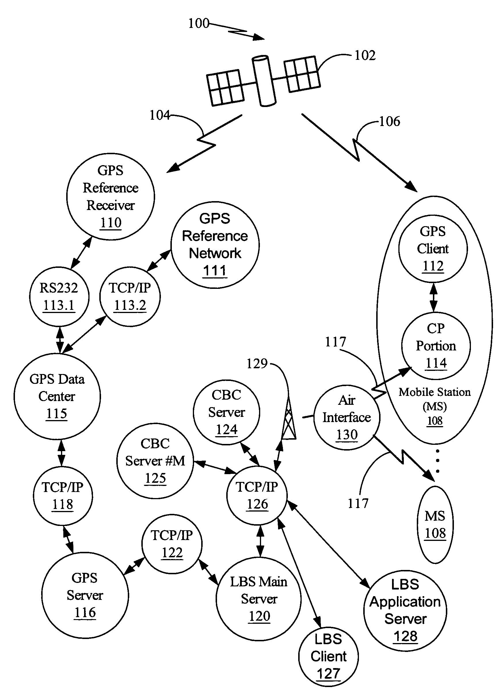
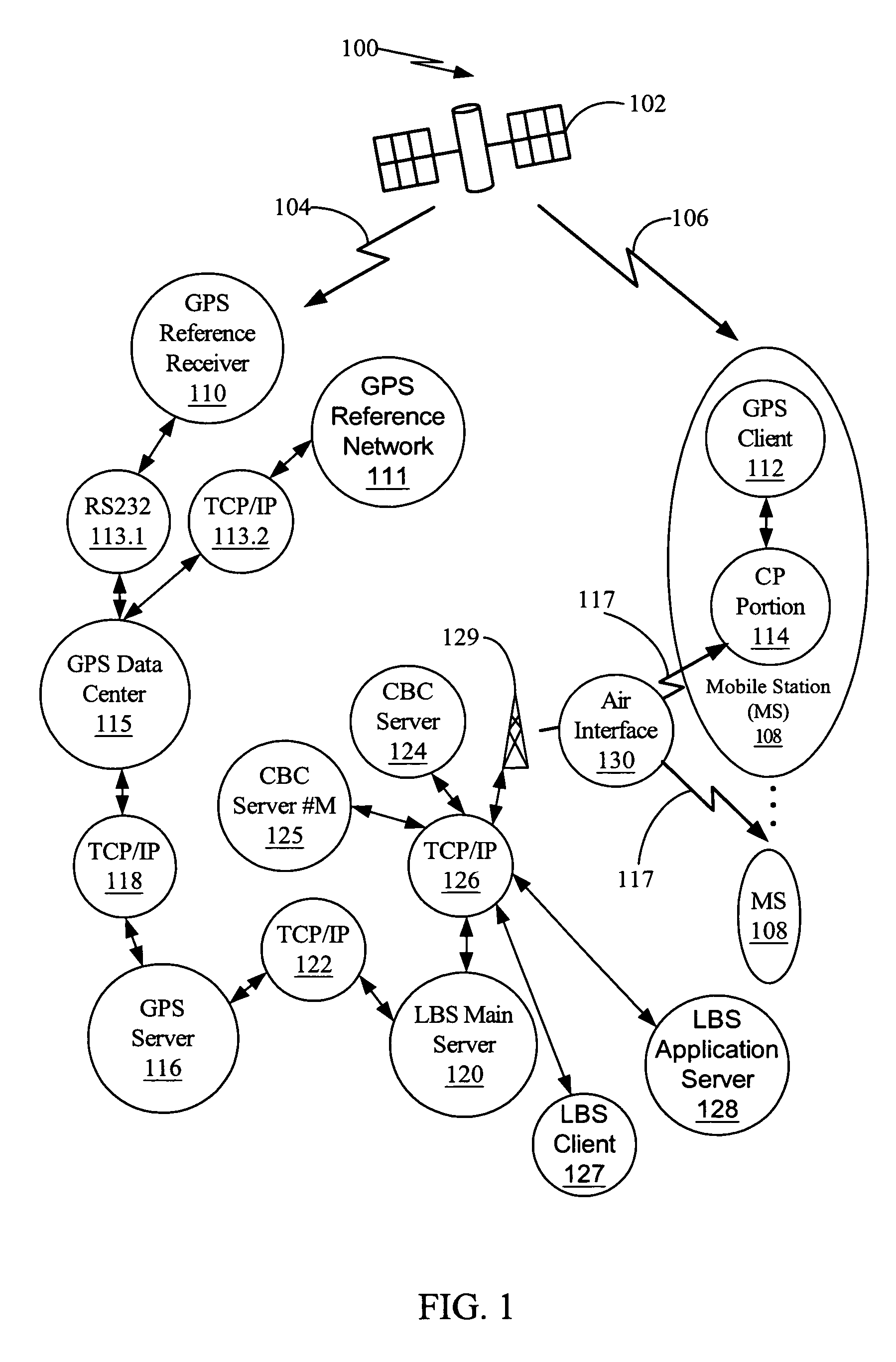
[0028]Unlike the known approaches previously discussed, an aided GPS broadcast positioning approach enables a network, such as a cellular network to provide aiding or assistance data to multiple Mobile Stations using a broadcasting of aiding data as opposed to a point-to-point aiding approach (one server to provide aiding or assistance data to one Mobile Station). The aided GPS broadcast approach requires less network resources to implement in a network than traditional point-to-point aiding approaches.

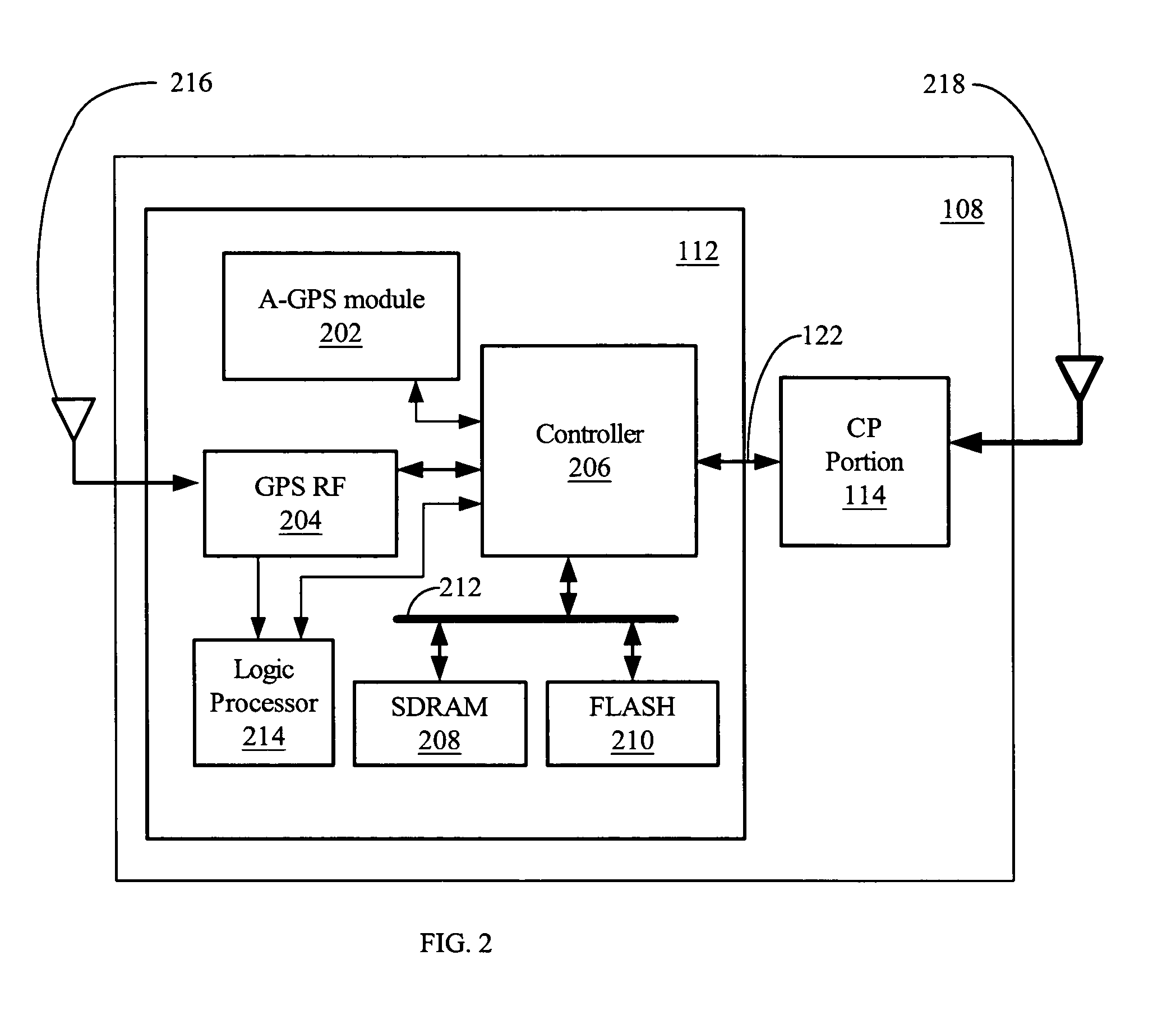
[0029]Turning first to FIG. 1, a functional framework of a satellite position system 100 is shown. A plurality of satellites, one of which is shown 102, orbits the Earth in a constellation. An example of such a satellite constellation is the global positioning system (GPS) operated by the United States Government. The satellite 102 communicates 104 and 106 with a GPS enabled device such as Mobile Station 108 and a GPS reference receiver 110. The Mobile Station 108 may have a GPS clien...


PUM


Abstract

A network approach for aided GPS broadcast positioning where A-GPS data is made available in the network and broadcast via cell broadcast servers to wireless devices in order to reduce the time required to determine the position of a wireless device.

Description

RELATED APPLICATIONS[0001]This application is a continuation-in-part of and claims priority to U.S. patent application Ser. No. 10 / 154,138, filed on May 21, 2002, entitled “METHOD FOR SYNCHRONIZING A RADIO NETWORK USING END USER RADIO TERMINALS,” by Gregory B. Turetzky et al, that claims priority under 35 U.S.C. §119(e) of U.S. Provisional Patent Application No. 60 / 292,774, filed May 21, 2001, entitled “METHOD FOR SYNCHRONIZING A RADIO NETWORK USING END USER RADIO TERMINALS,” by Gregory B. Turetzkey et al, U.S. patent application Ser. No. 10 / 874,775, filed on Jun. 23, 2004, titled “VIRTUAL SATELLITE POSITION SYSTEM SERVER,” by Ashutosh Pande, Steve Chang, Lionel Jacques Garin, and Qiyue John Zhang, and U.S. patent application Ser. No. 11 / 089,455, filed on Mar. 24, 2005, titled “SYSTEM AND METHOD FOR PROVIDING LOCATION BASED SERVICES OVER A NETWORK,” by Steve Chang, Ashutosh Pande, Lionel Jacques Garin, Kanwar Chadha, Leon Kuo-Liang Peng, Gengsheng Zhang, Nicolas Patrick Vantalon, an...

Claims


Application Information

Patent Timeline
Patent Type & Authority Patents(United States)
IPC IPC(8): H04W68/00G01S19/05H04W4/00H04W64/00
CPCG01S19/05G01S19/37H04W64/00G01S19/07G01S19/256G01S19/258H04W4/00G01S19/074
Inventor CHANG, STEVE
Owner CSR TECH INC
Why Eureka
Try Eureka