Systems and methods for coordination of entities and/or communicating location information

a technology of coordinate information and entity, applied in the field of coordinate information of entities and/or communication of location information, can solve the problems of a human operator's near impossible ability to operate, the potential for mid-air collision between two or more uavs, and the death of at least one, possibly all, of the uav

Active Publication Date: 2011-02-22
L3HARRIS TECH INTEGRATED SYST LP
View PDF13 Cites 43 Cited by
  • Summary
  • Abstract
  • Description
  • Claims
  • Application Information

AI Technical Summary

Benefits of technology

[0006]In one exemplary embodiment, the disclosed systems and methods may be implemented in a stand-alone manner to allow a group of two or more aerial vehicles (e.g., UAVs) to fly in an autonomous covey or formation. In such an embodiment, a group of aerial vehicles may be made aware of other aerial vehicles operating within close proximity and in a manner that substantially reduces or eliminates the potential for mid-air collisions between two or more of the aerial vehicles. Each of the aerial vehicles may be made aware of other aerial vehicles in its immediate airspace and, when appropriate, to take evasive action to avoid collision with another aerial vehicle in the group. A rule-based flight coordination protocol may be implemented (e.g., by computer processor / s or other type / s of suitable processing component / s on each of the aerial vehicles) to provide effective de-confliction of flight paths on a real-time or near real-time basis. Such a rule-based flight coordination protocol may be consistent and simple, e.g., to cause each aerial vehicle to turn right when approaching another aerial vehicle in a head-on direction so that a collision is avoided between the two aerial vehicles.
[0008]The disclosed systems and methods may be implemented in one embodiment, for example, in a standalone manner to provide flight inputs to an aerial vehicle autopilot in order to make adjustment in real time to the aerial vehicle flight path, e.g., the flight inputs may be input in a manner that does not alter existing waypoints but rather alters the trajectory vector a aerial vehicle uses to obtain a waypoint. The disclosed systems and methods may also be advantageously implemented in one exemplary embodiment to allow each aerial vehicle of a group (i.e., covey) of multiple aerial vehicles to transmit a pulsed RF signal (with timing-encoded latitude and longitude values) to the other aerial vehicles of the group on the same RF signal carrier frequency used by the other aerial vehicles to transmit similar pulsed RF signals. This capability to use the same RF signal carrier frequency for all aerial vehicles allows geographic location information to be exchanged between members of the group of aerial vehicles in a manner that is very efficient in the frequency domain.

Problems solved by technology

In flight operation of a covey or formation of multiple unmanned aerial vehicles (UAVs) flying in close proximity presents significant potential for mid air collisions between two or more of the UAVs.
It is expected that any such mid air collisions will prove fatal to a least one, and possibly all, of the UAVs involved in such a collision.
Maintaining a sphere of free (or empty) airspace around each UAV operating in a small covey or formation presents a major challenge to a human operator, and can become nearly impossible for a human operator when the covey size increases in number and / or when individual UAVs of the covey work in very close proximity.
Although this may present an initial solution to successful operation of larger UAV coveys, adding more human operators may become impractical as the covey size grows further in number.

Method used


Image

  • Systems and methods for coordination of entities and/or communicating location information
  • Systems and methods for coordination of entities and/or communicating location information
  • Systems and methods for coordination of entities and/or communicating location information

Examples


Embodiment Construction

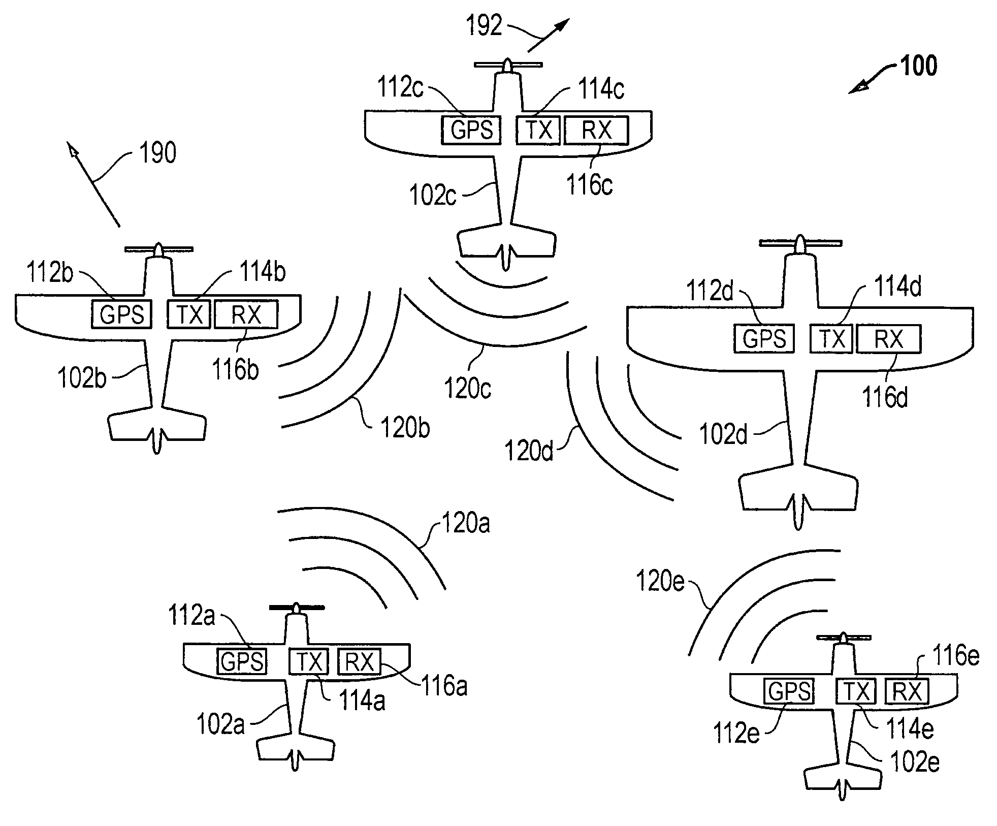
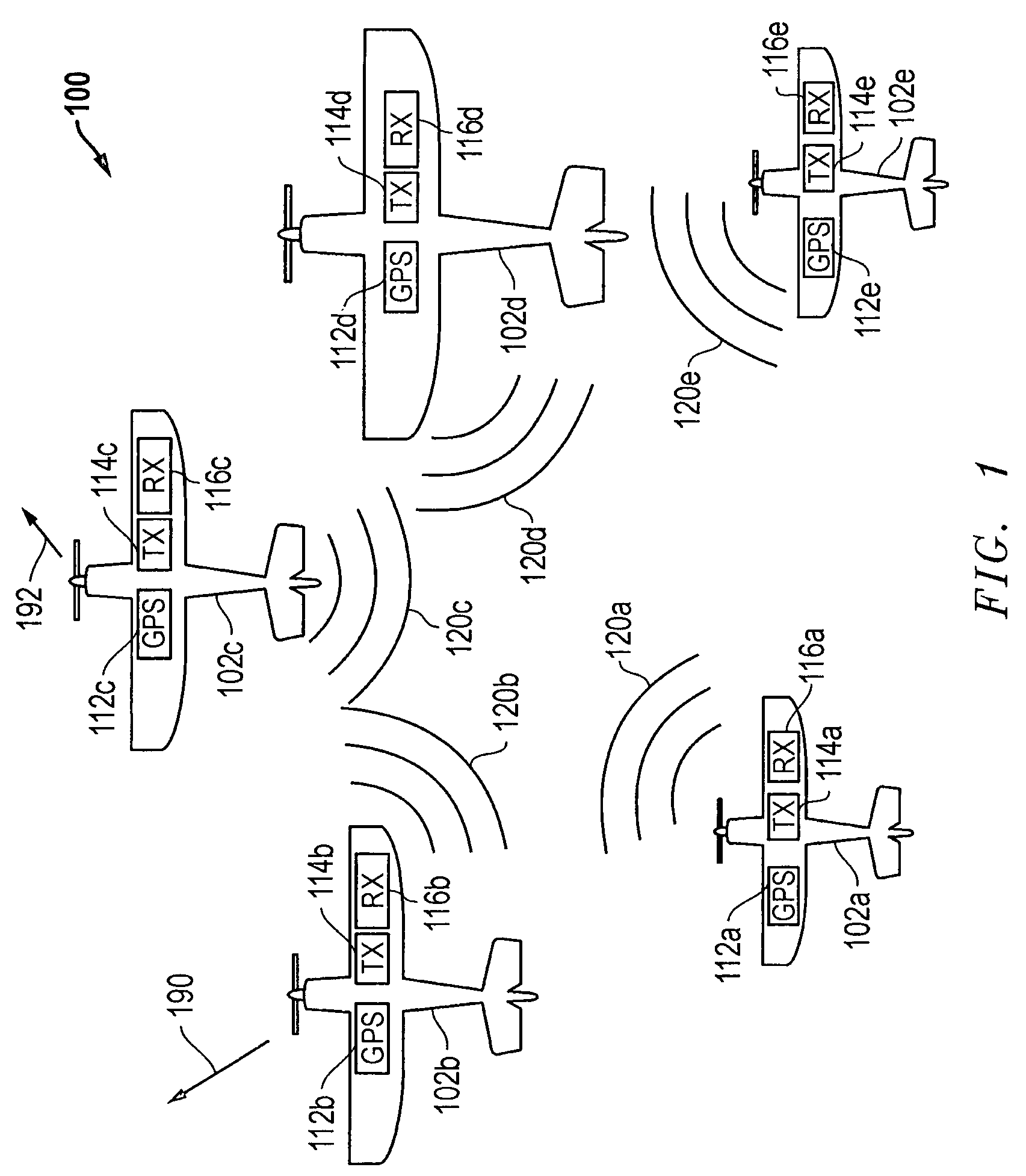
[0018]FIG. 1 is an overhead view of a group (i.e., covey) 100 of airborne aerial vehicles 102a to 102e, each of which is a UAV in this exemplary embodiment. In this exemplary embodiment, aerial vehicles 102a to 102e are shown flying with similar headings and at different altitudes (represented by the different apparent sizes of the aerial vehicles). Such a group configuration of aerial vehicles may be implemented, for example, to perform aerial surveillance (e.g., for traffic, weather, news, military, police or border surveillance purposes), airborne sample collection purposes, cargo transport purposes or for any other purpose that may be suitably performed by a group of aerial vehicles. It will be understood that aerial vehicles 102 of group 100 may be operating in a partially autonomous manner (e.g. with some external guidance or control provided by a ground or air-based human controller for operational and / or navigational purposes) or may be operating in a completely autonomous m...


PUM


Abstract

Systems and methods that may be employed to communicate location information between two or more aerial vehicles or other types of vehicles or other entities, and / or that may be used to facilitate coordinated operations of two or more such entities. In one example, an aerial vehicle may be kept aware of one or more location (e.g., longitude, latitude, etc.) and / or flight characteristics (e.g., altitude, directional heading, airspeed, attitude, etc.) of one or more other adjacent aerial vehicles, and each such aerial vehicle may use that location information to adjust its flight path to maintain a safe sphere of empty airspace around itself.

Description

FIELD OF THE INVENTION[0001]This invention relates generally to location, and more particularly, to coordination of entities and / or communication of location information.BACKGROUND OF THE INVENTION[0002]In flight operation of a covey or formation of multiple unmanned aerial vehicles (UAVs) flying in close proximity presents significant potential for mid air collisions between two or more of the UAVs. It is expected that any such mid air collisions will prove fatal to a least one, and possibly all, of the UAVs involved in such a collision. UAVs are typically controlled by human operators and operate with a ground system that is aware of their position. Maintaining a sphere of free (or empty) airspace around each UAV operating in a small covey or formation presents a major challenge to a human operator, and can become nearly impossible for a human operator when the covey size increases in number and / or when individual UAVs of the covey work in very close proximity. As the UAV covey si...

Claims


Application Information

Patent Timeline
Patent Type & Authority Patents(United States)
IPC IPC(8): G08G7/02G08G9/02G08G5/04G01S19/11
CPCG01S5/0027G05D1/104G01S2205/005
Inventor STROUD, KEN A.
Owner L3HARRIS TECH INTEGRATED SYST LP
Why Eureka
Try Eureka