System and method for geographic interpolation of traffic data

a traffic data and geographic interpolation technology, applied in the field of navigation systems, can solve the problems of inaccurate calculation of route data based on the speed limit in meshes, inability to provide traffic flow data for many geographic areas, and inability to meet the requirements of traffic flow data,

Active Publication Date: 2012-10-16
XANAVI INFORMATICS
View PDF16 Cites 7 Cited by
  • Summary
  • Abstract
  • Description
  • Claims
  • Application Information

AI Technical Summary

Problems solved by technology

Unfortunately, traffic flow data for many geographic areas is unavailable.
Such calculations of route data based upon the speed limit in meshes which do not contain traffic flow data but in which the speed limit is defined, however, have proven somewhat inaccurate in operation.
Consequently, since the previously known navigation systems statically preassign a speed value derived from the speed limit for road links of the same type in meshes which do not contain traffic flow data when performing route calculations, errors may occur resulting in inaccurate routing of the optimal route between the location of the vehicle and the destination.

Method used


Image

  • System and method for geographic interpolation of traffic data
  • System and method for geographic interpolation of traffic data
  • System and method for geographic interpolation of traffic data

Examples


Embodiment Construction

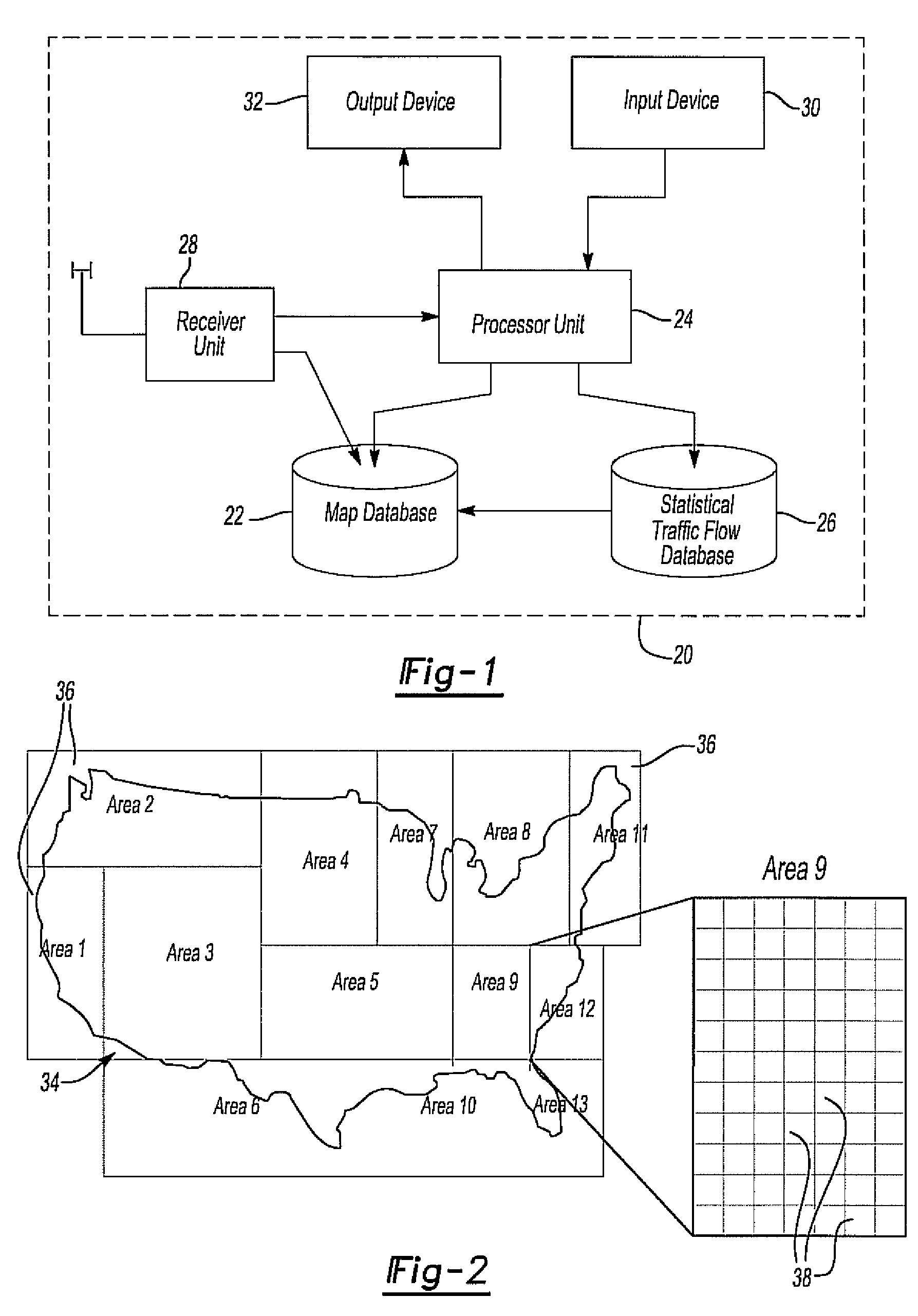
[0026]With reference first to FIG. 1, a simplified block diagrammatic view of a navigation system 20 according to the present invention is illustrated. The navigation system 20 includes a map database 22 which contains information relating to road links. Such information also includes the type of road link. For example, an interstate highway constitutes one type of road link whereas a two lane paved road constitutes a different type of road link and so on. The map database 22 also contains information relating to speed values preassigned according to the link road type, often derived from the typical speed limits for the road link type.

[0027]The information in the map database 22 is accessed by a processor 24 when calculating the position of the vehicle and also performing route calculations between the position of the automotive vehicle containing navigation system 20 and the vehicle destination. The processor 24 also accesses a statistical traffic flow database 26 which contains s...


PUM


Abstract

A method for geographic interpolation of traffic data in a vehicle navigation system in which the navigation system includes a map database divided into geographic meshes. Each mesh includes a plurality of road links of different types. That data also includes a first set of meshes containing traffic flow data while a mutually exclusive second set of meshes contains no such traffic flow data. A border between the first and second set of meshes is first identified and thereafter a blend zone of blend meshes is created by selecting at least one mesh adjacent the border so that the blend mesh is interposed between the first and second set of meshes. Thereafter, the traffic data for each type of road link in the blend mesh is adjusted to a value intermediate the first and second set of adjacent meshes for each type of road link and the blend mesh data is then stored.

Description

BACKGROUND OF THE INVENTION[0001]I. Field of the Invention[0002]The present invention relates generally to navigation systems and, more particularly, to a navigation system with means for geographic interpolation of traffic data.[0003]II. Description of Related Art[0004]Navigation systems of the type used in automotive vehicles have enjoyed increased popularity in recent years. Such navigation systems are particularly useful for providing route information on a display screen visible to the operator of the motor vehicle. In order to obtain the directions to a desired destination, the operator of the motor vehicle typically inputs the address of the destination by a touch screen or other means. After the destination has been inputted to the navigation system, it then computes the desired route which is typically the fastest route between the current location of the vehicle and the destination.[0005]In order for the navigation system to compute the route from the current location of t...

Claims


Application Information

Patent Timeline
Patent Type & Authority Patents(United States)
IPC IPC(8): G01C21/00G06G7/76G06G7/70G08G1/123G08G1/00G06F19/00
CPCG01C21/26G08G1/096844
Inventor HORIGUCHI, SADANORIMACHII, KIMIYOSHIKATO, MANABU
Owner XANAVI INFORMATICS
Why Eureka
Try Eureka