
Map information processing apparatus

a technology of information processing and map data, applied in surveying and navigation, instruments, navigation instruments, etc., can solve the problems of not being able to acquire correct unable to store correct track data about an unregistered road, and unable to store correct track data

Inactive Publication Date: 2013-02-19
MITSUBISHI ELECTRIC CORP
View PDF18 Cites 2 Cited by
  • Summary
  • Abstract
  • Description
  • Claims
  • Application Information

AI Technical Summary

Benefits of technology

[0010]In accordance with the present invention, the map information processing apparatus is constructed in such a way as to, when the specified detection start point and specified detection end point of the unregistered road are inputted from the input unit, detect, as the unregistered road, a section between the detection start point and the detection end point of the unregistered road which are acquired on the basis of either the map matching carried out by the road matching means or the result of the comparison between the running track data read from the memory and the road data read from the above-mentioned map data storage means. Therefore, the map information processing apparatus can prevent incorrect matching from being established between the running track data and the road data and can acquire correct data about the unregistered road. As a result, the map information processing apparatus can correctly add the unregistered road to the map information as a registered road.

Problems solved by technology

However, because the navigation apparatus shown in above-mentioned patent reference 1 compares roads shown by the road information with the vehicle position, and sequentially stores the track data about the vehicle in the road information memory while carrying out map matching of modifying the vehicle position in such a way that the vehicle position is located on a road, when the vehicle is running along an unregistered road, the navigation apparatus enters a state in which the navigation apparatus provides erroneous map matching between the vehicle position and a road in the vicinity of the unregistered road, and therefore cannot store correct track data about the unregistered road in the road information memory.
As a result, there arises a problem that correct data about an unregistered road cannot be acquired.
A problem is therefore that a case in which any reference point which is set up beforehand does not match the start point or the end point of an unregistered road correctly occurs, and correct data about an unregistered road cannot be acquired.

Method used


Image

  • Map information processing apparatus
  • Map information processing apparatus
  • Map information processing apparatus

Examples


embodiment 1

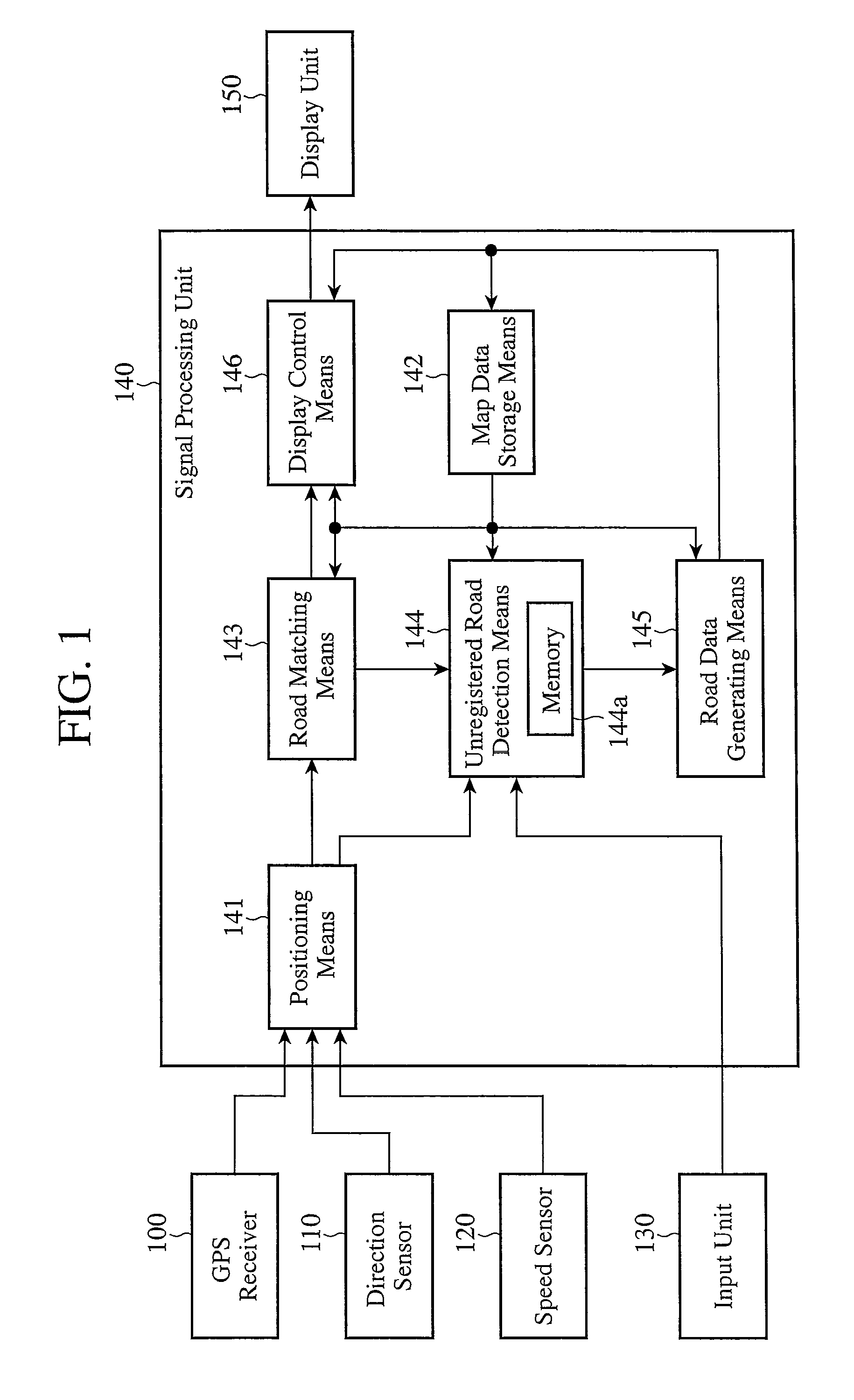
[0031]FIG. 1 is a block diagram showing the structure of a navigation apparatus to which a map information processing apparatus in accordance with Embodiment 1 of the present invention is applied. This navigation apparatus is comprised of a GPS (Global Positioning System) receiver 100, a direction sensor 110, a speed sensor 120, an input unit 130, a signal processing unit 140, and a display unit 150.

[0032]The GPS receiver 100 calculates position information, such as the latitude, the longitude, the altitude, and so on of the current position of a vehicle from signals which the GPS receiver acquires by receiving electric waves from satellites (GPS satellites). The position information calculated by this GPS receiver 100 is sent to the signal processing unit 140. The direction sensor 110 is comprised of, for example, a gyro sensor, and detects the running direction of the vehicle. Direction information showing the running direction detected by this direction sensor 110 is sent, as aut...

embodiment 2

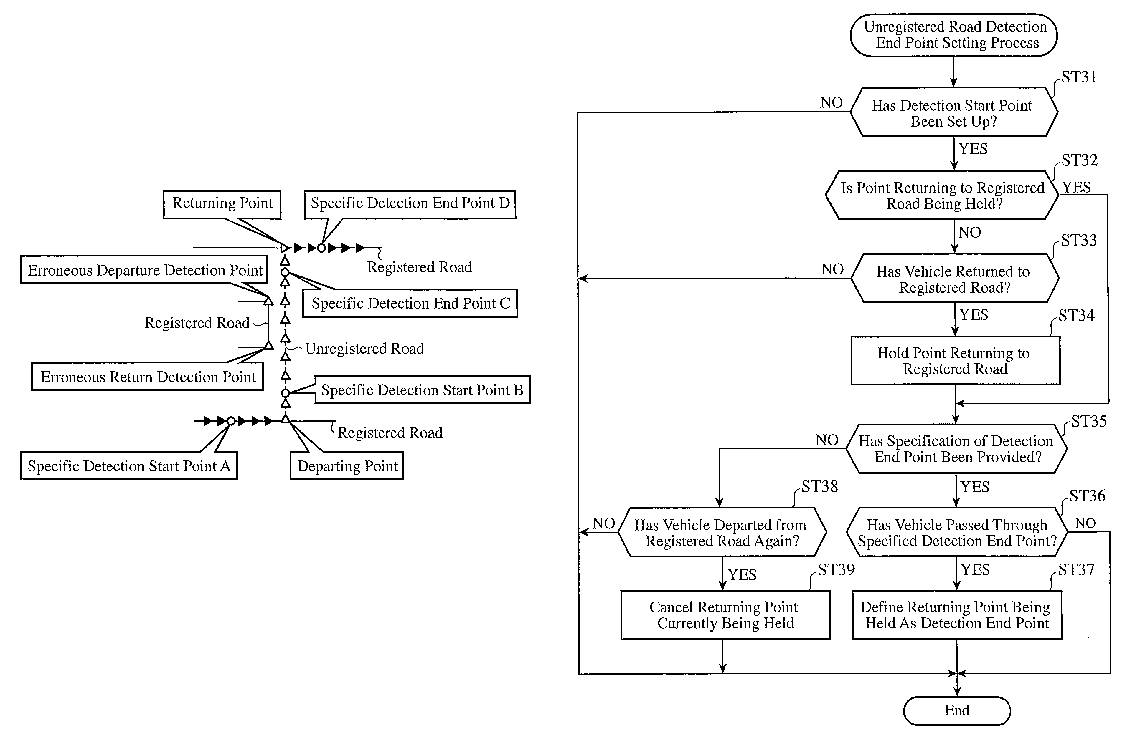
[0082]A map information processing apparatus in accordance with Embodiment 2 of the present invention is constructed in such a way as to end detection of the detection start point of an unregistered road when no departure from any registered road has been detected during running over a predetermined distance or more or during a predetermined time period or more.

[0083]The structure of the map information processing apparatus in accordance with this Embodiment 2 is the same as that of the map information processing apparatus in accordance with Embodiment 1.

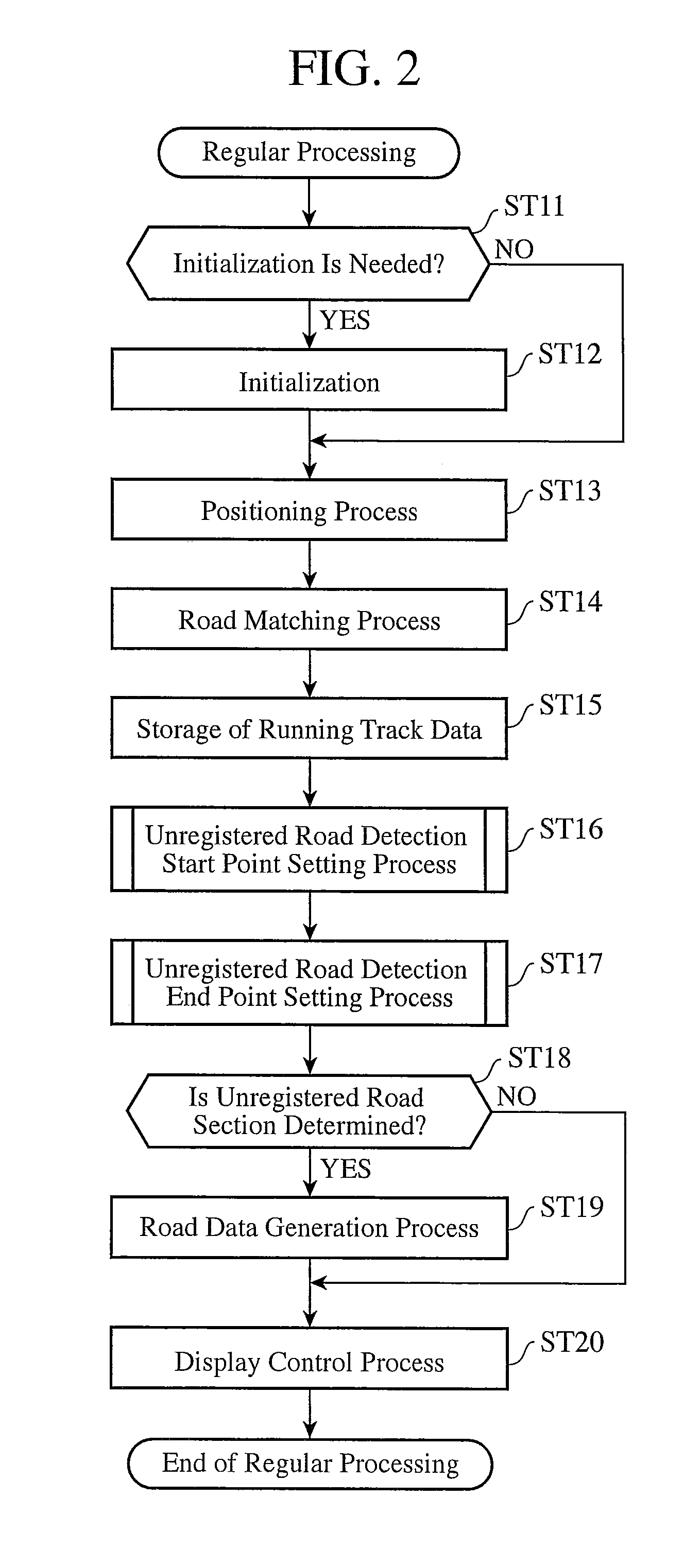
[0084]Next, the operation of the map information processing apparatus in accordance with Embodiment 2 of the present invention will be explained. Regular processing which is performed under normal operating conditions by the map information processing apparatus in accordance with Embodiment 2 is fundamentally the same as that of the map information processing apparatus in accordance with Embodiment 1 shown in the flow chart of FIG. ...

embodiment 3

[0090]A map information processing apparatus in accordance with Embodiment 3 of the present invention ends detection of the detection end point of an unregistered road even if the user does not provide an instruction for ending the detection therefor when the vehicle runs over a predetermined distance or more or during a predetermined time interval or more after the vehicle has returned to a registered road.

[0091]The structure of the map information processing apparatus in accordance with this Embodiment 3 is the same as that of the map information processing apparatus in accordance with Embodiment 1.

[0092]Next, the operation of the map information processing apparatus in accordance with Embodiment 3 of the present invention will be explained. Regular processing which is performed under normal operating conditions by the map information processing apparatus in accordance with Embodiment 3 is fundamentally the same as that of the map information processing apparatus in accordance wit...


PUM


Abstract

A map information processing apparatus includes a road matching means (143) for comparing the road data with current position data to carry out map matching, an input unit (130) for inputting both a specified detection start point and a specified detection end point, an unregistered road detection means (144) to which both the specified detection start point and the specified detection end point are inputted, for detecting, as an unregistered road, a section between a detection start point and a detection end point of the unregistered road which are acquired on the basis of either the map matching carried out by the road matching means or the result of comparison between running track data and the road data, and a road data generating means (145) for generating road data corresponding to the detected unregistered road and storing the road data in a map data storage means.

Description

FIELD OF THE INVENTION[0001]The present invention relates to a map information processing apparatus which processes map information. More particularly, it relates to a technology of detecting an unregistered road which has not been registered into a map database to register the unregistered road into the map database.BACKGROUND OF THE INVENTION[0002]As a technology of registering an unregistered road into a map database, patent reference 1 discloses a navigation apparatus which, when a vehicle passes through a road whose information is not included in its road information, holds the information and registers, as a new road, the road therein to enable navigation without waiting for an update or revision of a CD-ROM having the road information. This navigation apparatus is provided with a GPS receiving unit, a display unit for displaying the vehicle position, a CD-ROM drive unit for reading data from the CD-ROM which stores the map information, and a control unit having a road informa...

Claims


Application Information

Patent Timeline
Patent Type & Authority Patents(United States)
IPC IPC(8): G01C21/00
CPCG01C21/30G01C21/32G01C21/3844G01C21/3815
Inventor NAKAE, TOMOHIROKOHNO, ATSUSHIIKEUCHI, TOMOYAUMEZU, MASAHARUMIKURIYA, MAKOTOSHIMOTANI, MITSUOSATOU, FUMITAKAKAWANA, YUTA
Owner MITSUBISHI ELECTRIC CORP
Learn More