Weighted-distance spatial indexing

a weighted distance and spatial indexing technology, applied in the field of spatial searches, can solve the problems of slowing down the search, reducing the usefulness of spatial searches, and difficult implementation of spatial searches based on weighted distances

Active Publication Date: 2015-02-17
GOOGLE LLC
View PDF7 Cites 16 Cited by
  • Summary
  • Abstract
  • Description
  • Claims
  • Application Information

AI Technical Summary

Problems solved by technology

For a variety of reasons, spatial searches based on weighted distances are difficult to implement.
Weighted-distance spatial searches often include evaluating a relatively large number of candidate items as potential search results because heavy weightings can cause relatively distant items to be responsive to a query.
Evaluating a large number of candidate items often slows the search and diminishes the usefulness of spatial searches.

Method used


Image

  • Weighted-distance spatial indexing
  • Weighted-distance spatial indexing
  • Weighted-distance spatial indexing

Examples


Embodiment Construction

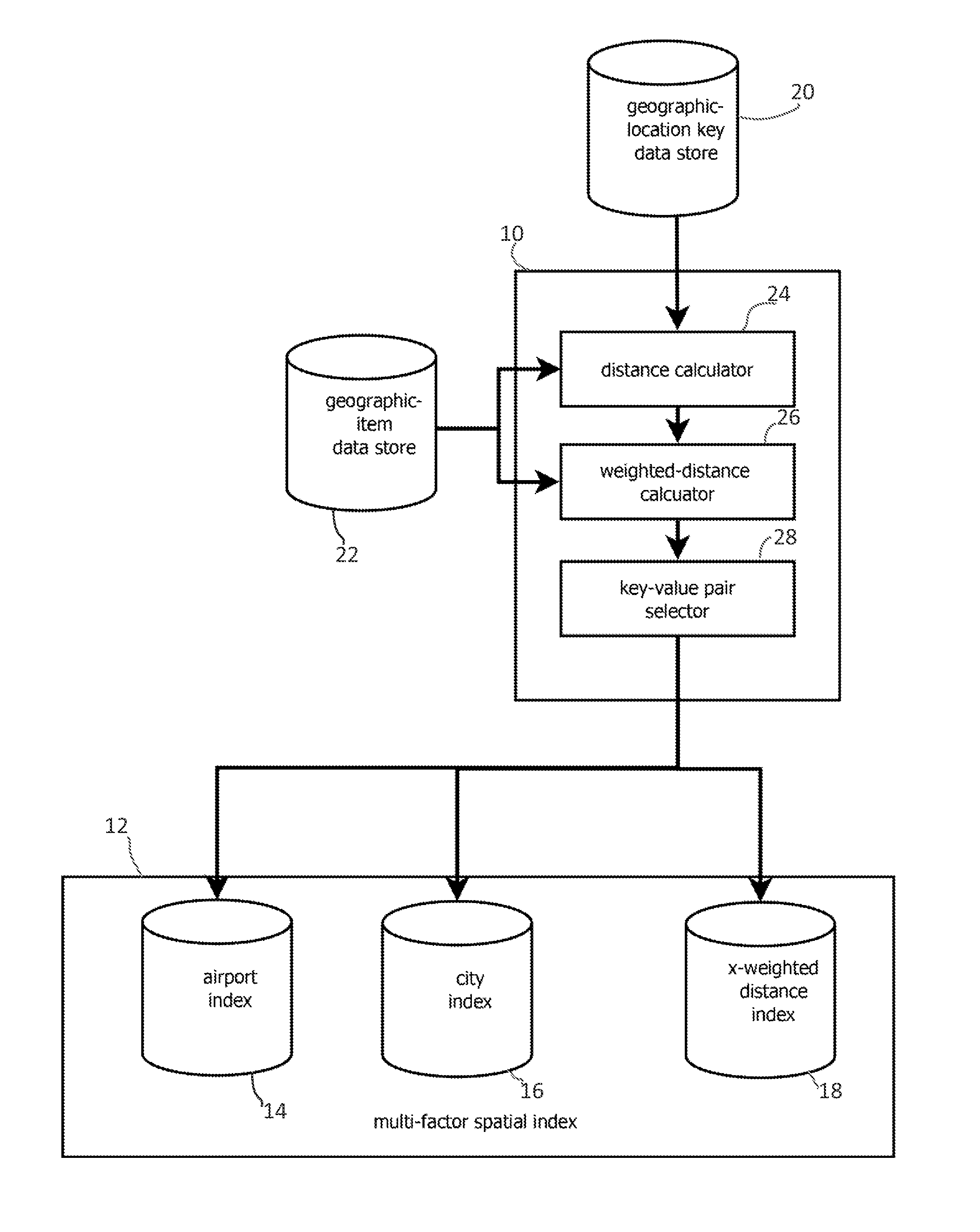
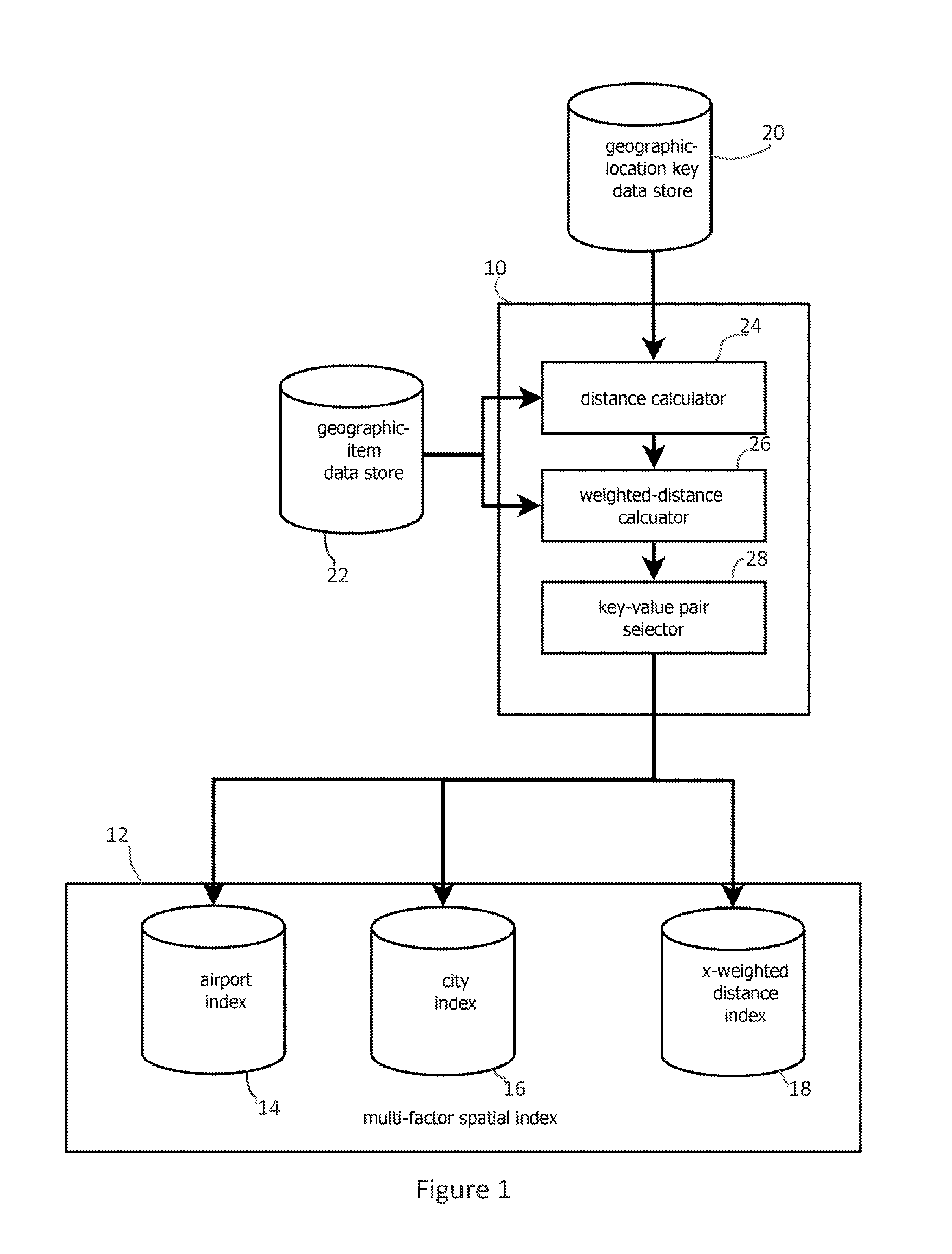
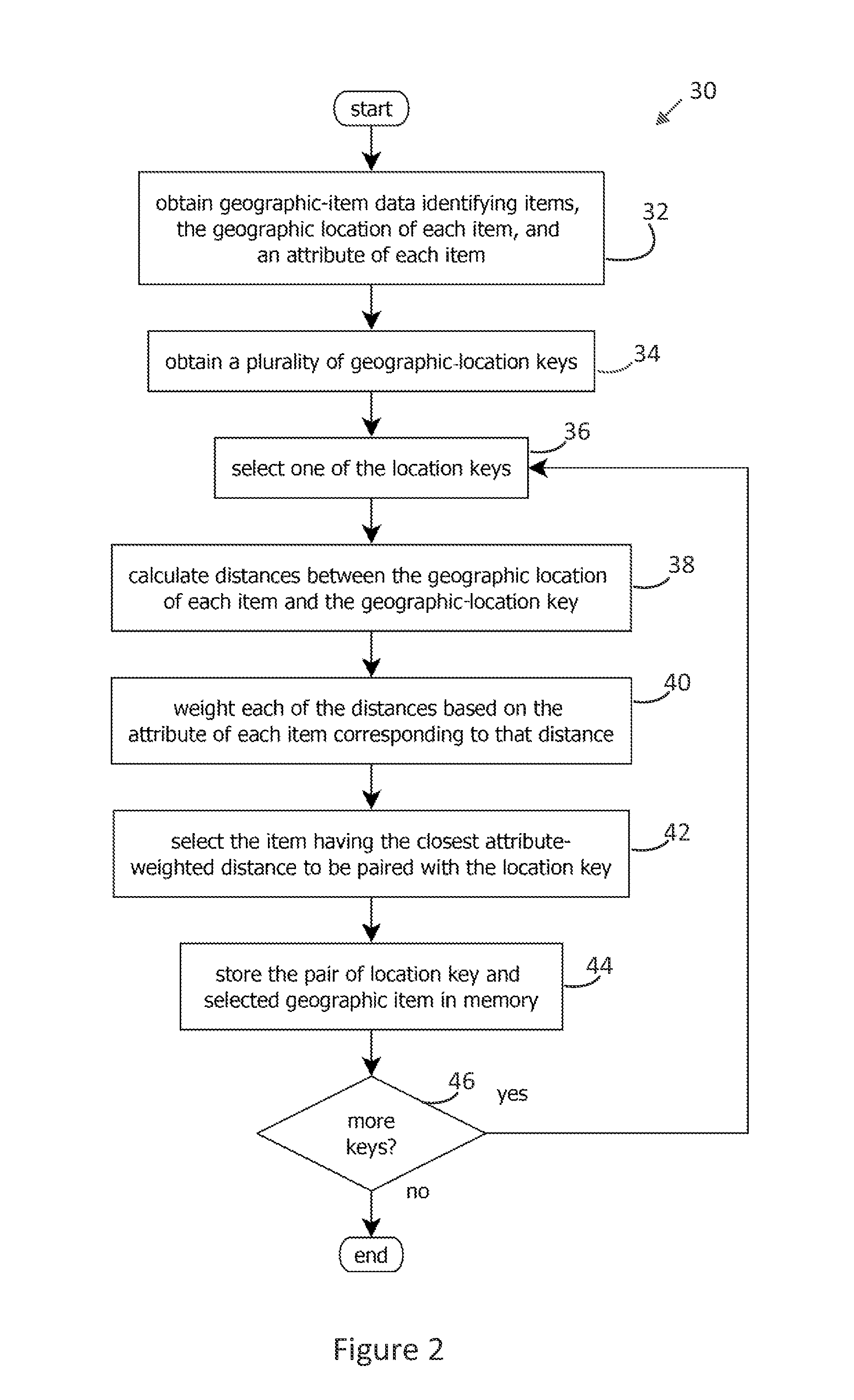
[0023]FIG. 1 shows an embodiment of a spatial indexer 10 that forms indexes 12 for expediting weighted-distance spatial searches. The indexes may map a set of geographic locations about which a searcher may base a query to geographic items responsive to that query. For instance, geographic locations may be mapped to airports, cities, restaurants, or other items in the index. Which item is paired with a location may be based on a weighted distance between that item and the location, e.g., based on both the distance from the location to an airport and the capacity of that airport.

[0024]The spatial indexer 10 may be capable of forming multiple spatial indexes 14, 16, and 18, each reflecting different distance-weighting functions. For instance, index 14 may be a spatial index of airports based on distances weighted by airport capacity, and index 16 may be a spatial index of cites based on distances weighted by city population. (Three spatial indexes are shown, but other embodiments may ...


PUM


Abstract

Provided is a process of and apparatus for spatially indexing geographic items. The process may include obtaining geographic-item data identifying geographic items, the geographic location of each item, and an attribute of each item, wherein the geographic-item data identifies values of key-value pairs to be formed in a spatial index; obtaining a plurality of geographic-location keys each corresponding to a geographic area, the geographic-location keys identifying keys of the key-value pairs to be formed in the spatial index; and pairing each geographic-location key with an item among the geographic-item data. Pairing may be performed by: calculating distances between the geographic location of each of the items and the geographic-location key; weighting each of the distances based on the attribute of the item corresponding to that distance; and selecting the geographic item having the closest attribute-weighted distance as the item to be paired with the geographic-location key.

Description

BACKGROUND OF THE INVENTION[0001]1. Field of the Invention[0002]The present invention relates generally to spatial searches and, more specifically, to spatial searches ranked according to weighted distances.[0003]2. Description of the Related Art[0004]Spatial searches, or searches in which the search results depend upon geographic location, have a variety of uses. For example, users may query a spatial-search engine for pizza parlors near the user's location (requesting, for instance “pizza near zip code 78701”), and a spatial search responsive to that query may return one or more pizza parlors ranked based on the distance between the pizza parlor and the reference location of zip code 78701. Similar queries may occur in scenarios in which a user is planning a vacation and searches for, for example, airports near a hotel in which the user has booked a room, or in scenarios in which content for a web page is selected based on geographic location, for example, an advertisement for a p...

Claims


Application Information

Patent Timeline
Patent Type & Authority Patents(United States)
IPC IPC(8): G06F15/16H04W4/02
CPCH04W4/02G06F16/24578
Inventor MURPHY, BRUCE WINSTON
Owner GOOGLE LLC
Why Eureka
Try Eureka