Geospatial construction task management system and method

a task management system and geospatial technology, applied in the field of geospatial construction task management system and method, can solve the problems of long and complicated schedules, delays in task completion and/or project, and inconvenient use, etc., to achieve efficient, effective, functional and convenient

Inactive Publication Date: 2016-08-23
HITO MANAGEMENT CO
View PDF13 Cites 42 Cited by
  • Summary
  • Abstract
  • Description
  • Claims
  • Application Information

AI Technical Summary

Benefits of technology

[0006]Various aspects of the disclosure provide more efficient, effective, functional, and convenient ways of providing geospatial worksite management for large-scale construction projects. In particular, in one or more embodiments discussed in greater detail below, geospatial worksite management functionalities are implemented, and/or used in a number of different ways to provide one or more of these and/or other advantages.
[0007]A mobile device such as a smartphone or tablet may display a geographic map of a construction site with geographic areas that have scheduled activities depicted with shapes or markers overlaid on the geographic map. The geographic map...

Problems solved by technology

Currently, lengthy complicated schedules are used to coordinate timing and completion of these tasks.
As a result, a Gantt chart of this length is not useful to managers and field workers of the project since most of the information is not relevant to a particular worker.
Additionally, by the time the Gantt chart is analyzed and understood the information is outdated leading to delays in completion of tasks and/or the project.
Exacerbating the problem is that fact updates in the progress of the tasks are made by managers and workers once they return from the field rather than when they are in the field result...

Method used


Image

  • Geospatial construction task management system and method
  • Geospatial construction task management system and method
  • Geospatial construction task management system and method

Examples


Embodiment Construction

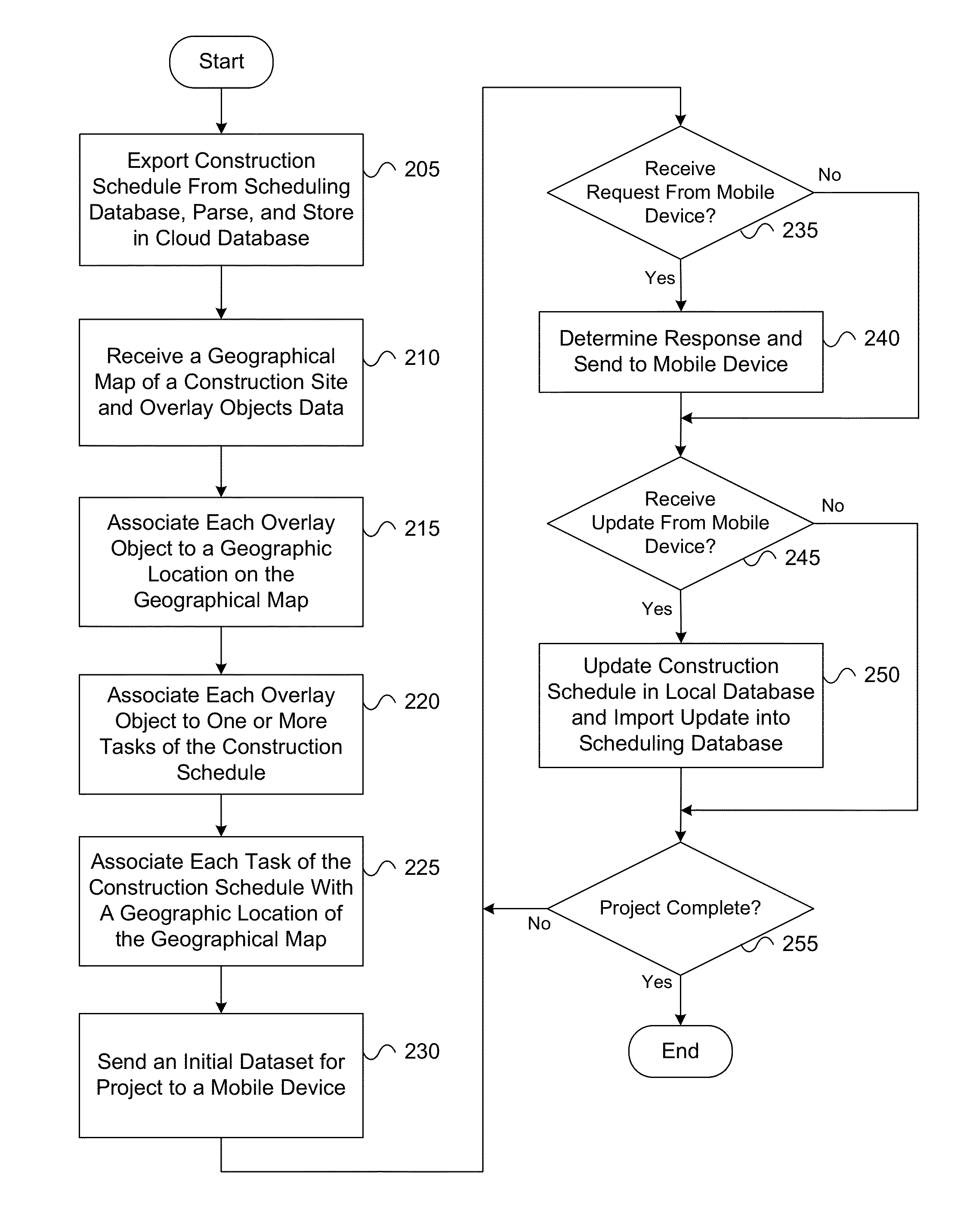
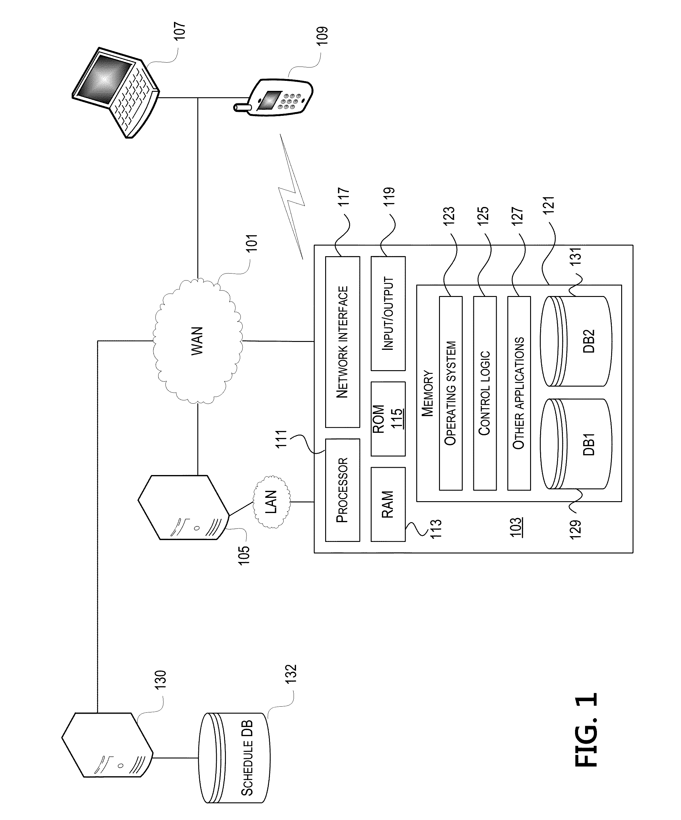
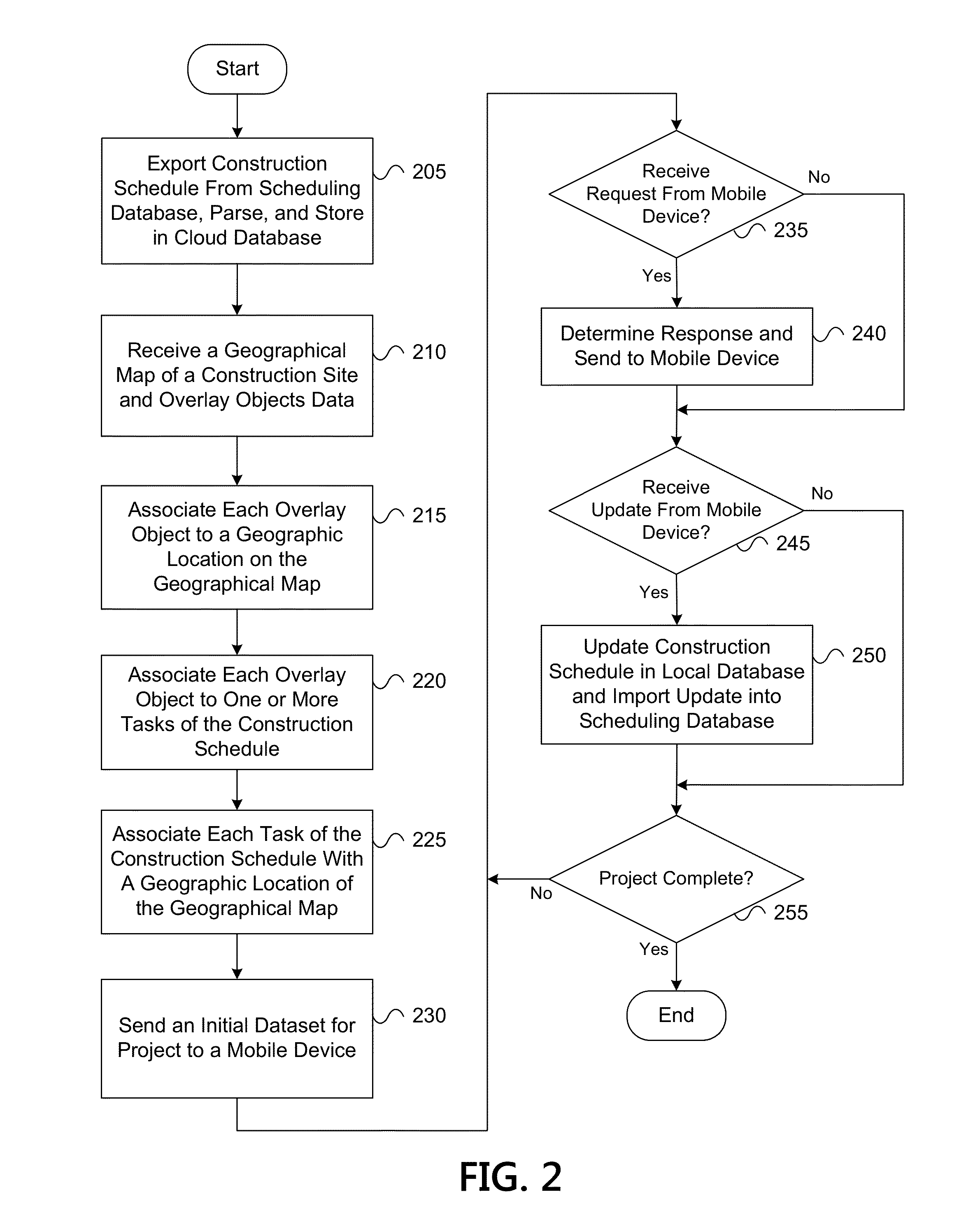
[0018]In the following description of the various embodiments, reference is made to the accompanying drawings, which form a part hereof, and in which is shown by way of illustration various embodiments in which the geospatial worksite management solution may be practiced. It is to be understood that other embodiments may be utilized and structural and functional modifications may be made without departing from the scope of aspects discussed herein. The geospatial worksite management system is capable of other embodiments and of being practiced or being carried out in various ways.

[0019]Also, it is to be understood that the phraseology and terminology used herein are for the purpose of description and should not be regarded as limiting. Rather, the phrases and terms used herein are to be given their broadest interpretation and meaning. The use of “including” and “comprising” and variations thereof is meant to encompass the items listed thereafter and equivalents thereof as well as ad...


PUM


Abstract

Methods, systems, computer-readable media, and apparatuses for providing geospatial worksite management for large-scale construction projects are presented. In some embodiments, a computing device may receive a geographic map of a construction site and a construction schedule including multiple tasks. The computing device may display the geographic map and receive a selection of a geographic location on the geographic map. The computing device may determine that a first set of tasks is associated with the geographic location and may display an object associated with the first set of tasks overlaid on the geographic map at the determined geographic location. The object may represent a structure to be constructed at the construction site.

Description

FIELD[0001]Aspects of the disclosure relate to computer hardware and software. In particular, one or more aspects of the disclosure generally relate to computer hardware and software for providing geospatial worksite management for large-scale construction projects.BACKGROUND[0002]Large-scale construction projects can include thousands of tasks that must be completed in a highly coordinated manner in order for the project to be completed on time. Currently, lengthy complicated schedules are used to coordinate timing and completion of these tasks. Many tools employ the use of Gantt charts to track the progress of the project, which is a data table along with a time scaled bar chart. However, when printed, the Gantt chart can be anywhere from 50 to 150 pages in length. As a result, a Gantt chart of this length is not useful to managers and field workers of the project since most of the information is not relevant to a particular worker. Additionally, by the time the Gantt chart is ana...

Claims


Application Information

Patent Timeline
IPC IPC(8): G06F7/00G06F3/0482G06F3/0484G06Q10/06
CPCG06Q10/063114G06F3/04842G06F3/0482G06F3/04847
Inventor LEE, JAMES
Owner HITO MANAGEMENT CO
Why Eureka
Try Eureka