Precision estimation for assisting GPS orientation

A technology of accuracy and GPS time, applied in positioning, satellite radio beacon positioning system, measuring device and other directions, can solve the problem of long processing time of calculation work, and achieve the effect of reliable positioning

Inactive Publication Date: 2009-02-25
TELEFON AB LM ERICSSON (PUBL)
View PDF1 Cites 6 Cited by
  • Summary
  • Abstract
  • Description
  • Claims
  • Application Information

AI Technical Summary

Problems solved by technology

This in turn results in unnecessarily high computational effort and unnecessarily long processing times

Method used


Image

  • Precision estimation for assisting GPS orientation
  • Precision estimation for assisting GPS orientation
  • Precision estimation for assisting GPS orientation

Examples


Embodiment Construction

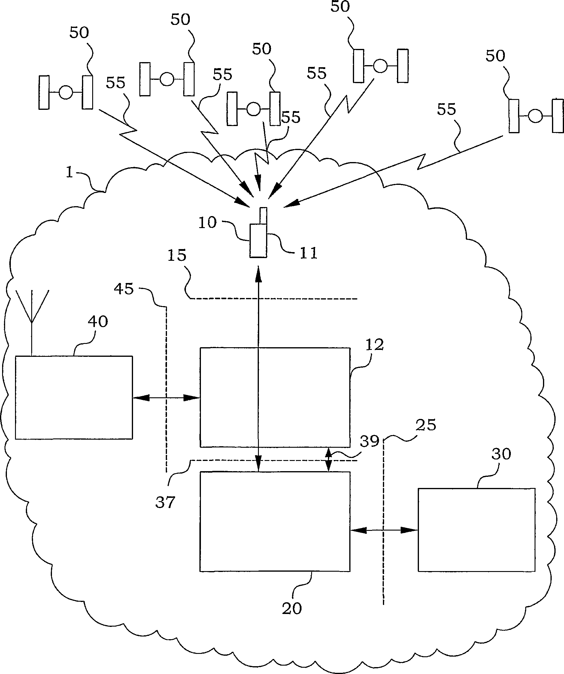
[0027] figure 1 An example of Assisted GPS (A-GPS) implemented in the cellular communication system 1 will be described. In this particular example, the cellular communication system 1 is a Wideband Code Division Multiple Access (WCDMA) system. However, the principles of the invention are also applicable to other cellular communication systems. In this system, a Radio Network Controller (RNC) 20 acts as a node that collects, refines and distributes assistance data for the mobile terminal 10 . The mobile terminal 10 is typically denoted as a User Equipment (UE) in a WCDMA environment, and in the disclosure of the present invention, these two terms will be used as synonyms. The Core Network (CN) 30 requests the positioning of the UE through the Radio Access Network Application Part (RANAP) interface 25 . In response, the RNC 20 may use different kinds of A-GPS techniques. However, all of these techniques are based on assistance data processed by nodes in the cellular commun...


PUM


Abstract

Reliable and efficient search windows are provided by allowing the adaptation of the code search window to be dependent on inaccuracy measures of relations between a cellular frame time and a satellite reference time. This inaccuracy is calculated in a positioning node (21) of the cellular communications system (1), preferably by filtering of measurements received from user equipments. Linear trend Kalman filtering followed by post processing of estimation errors is presently preferred. In order to ensure non-ambiguous interpretation of the received time stamps of received satellite signals (55) provided by user equipments (10), a pseudo propagation delay is computed in both the user equipment (10) and the positioning node (21) based on GPS acquisition assistance data. The GPS time stamp is then defined referring to the determined pseudo propagation delay.; In a preferred embodiment, the pseudo propagation delay is assured to be situated within a pre-determined time interval.

Description

technical field [0001] The present invention relates generally to the field of satellite based positioning, in particular satellite based positioning assisted by assistance data from a cellular communication system. Background technique [0002] Positioning or navigation technology has the purpose of determining the geographic location of an object, device, or person carrying it. The positions are typically given relative to a prescribed coordinate system. Such localization has become of increasing interest in many application areas in recent years. One way to solve positioning is to use signals sent from satellites to determine position. Well-known examples of such systems are the Global Positioning System (GPS) and the future GALILEO system. Based on the received plurality of satellite signals, the position is given as triangulation / trilateration with respect to a prescribed coordinate system. [0003] Assisted GPS (AGPS) is an enhancement of the GPS system to facilita...

Claims


Application Information

Patent Timeline
Patent Type & Authority Applications(China)
IPC IPC(8): G01S1/00G01S5/14G01S19/25
CPCG01S19/05G01S19/256
Inventor K·T·威格伦A·康加斯
Owner TELEFON AB LM ERICSSON (PUBL)
Why Eureka
Try Eureka