Method for releasing geospatial data incremental information

A technology of geospatial data and geographic information, which is applied in the field of publishing incremental information of geographic data, and can solve the problems of difficulty in updating the user terminal and low transmission efficiency.

Inactive Publication Date: 2009-10-21
WUHAN UNIV
View PDF0 Cites 17 Cited by
  • Summary
  • Abstract
  • Description
  • Claims
  • Application Information

AI Technical Summary

Problems solved by technology

Batch update provides users with all the content of the new version of data. This update method has many problems such as low transmission efficiency and difficulty in user-side update, while incremental update only provides customers with changed information. This update method is more scientific. is a more effective update information dissemination strategy
At present, the research on the update of incremental information is still in its infancy, and there are many problems that need to be further studied in both theory and method.

Method used


Image

  • Method for releasing geospatial data incremental information
  • Method for releasing geospatial data incremental information
  • Method for releasing geospatial data incremental information

Examples


Embodiment Construction

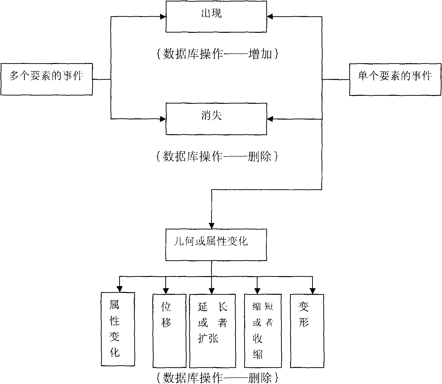
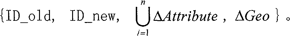
[0016] In order to facilitate the update of the client database, the present invention proposes a database operation-oriented incremental information definition based on event and snapshot difference types, which implies various events in the objective world. The incremental information based on operation and snapshot difference is recorded as ΔObject, ΔObject=[Diff, Operate], snapshot difference Diff = { ID _ old , ID _ new , ∪ i = 1 n ΔAttribute , ΔGeo } . ID_old, ID_new, and ΔGeo are snapshot difference items, where ID_old and ID_new are the identifiers of geographic objects in the old and new versions respectively, Indicates the collection of thematic attribute changes of geographic objects, ΔGeo represents the ge...


PUM


Abstract

The invention discloses a method for releasing geospatial data incremental information, which comprises the following steps: determining the semantic definition, classification, measurement and storage of the incremental information by organizing and modeling geographic incremental information; establishing an XML-based geographic incremental information storage medium which facilitates the release of the geographic incremental information and the update of a client; and storing the acquired incremental information in an XML format and releasing the XML incremental information. The method provides a database operation-oriented data description of the incremental information according to the change type and operation type of factors as well as the classic definition and classification of the incremental information, provides incremental information data expression in XML on the basis of geographic information data file expression and SGML expression, provides XML-based geographic incremental information storage, and has the advantages of self-description, flexibility, independence, expandability, high structural property and good cross-platform property.

Description

technical field [0001] The invention relates to a method for releasing geographic data incremental information, and belongs to the technical field of geographic information. Background technique [0002] With the expansion of the field of spatial data services and the continuous deepening of applications, users have put forward higher requirements for the accuracy, integrity and currentity of spatial data. Therefore, it has become a top priority for spatial data producers to continuously update geospatial databases, improve the current status of geospatial data, and distribute updated information to data users. [0003] According to the data content provided to its users, existing update services can be divided into batch update and incremental update. Batch update provides users with all the content of the new version of data. This update method has many problems such as low transmission efficiency and difficulty in user-side update, while incremental update only provides ...

Claims


Application Information

Patent Timeline
Patent Type & Authority Applications(China)
IPC IPC(8): G06F17/30G09B29/00
Inventor 应申李霖朱海红万远王园园
Owner WUHAN UNIV
Why Eureka
Try Eureka