Web GIS (geographic information system)-based elevation geographic data querying system and method
A geographic data and query system technology, applied in the fields of electrical digital data processing, special data processing applications, instruments, etc.
Inactive Publication Date: 2011-06-15
SHANGHAI OCEAN UNIV
View PDF0 Cites 10 Cited by
- Summary
- Abstract
- Description
- Claims
- Application Information
AI Technical Summary
Problems solved by technology
Therefore, how to provide more and more user-friendly functions in the geographic information system is a very necessary task, but in the current application system based on WebGIS, it is impossible to use the existing API to achieve the r...
Method used
View moreImage
Smart ImageViewing Examples

Examples
Embodiment Construction
Login to view more PUM
 Abstract
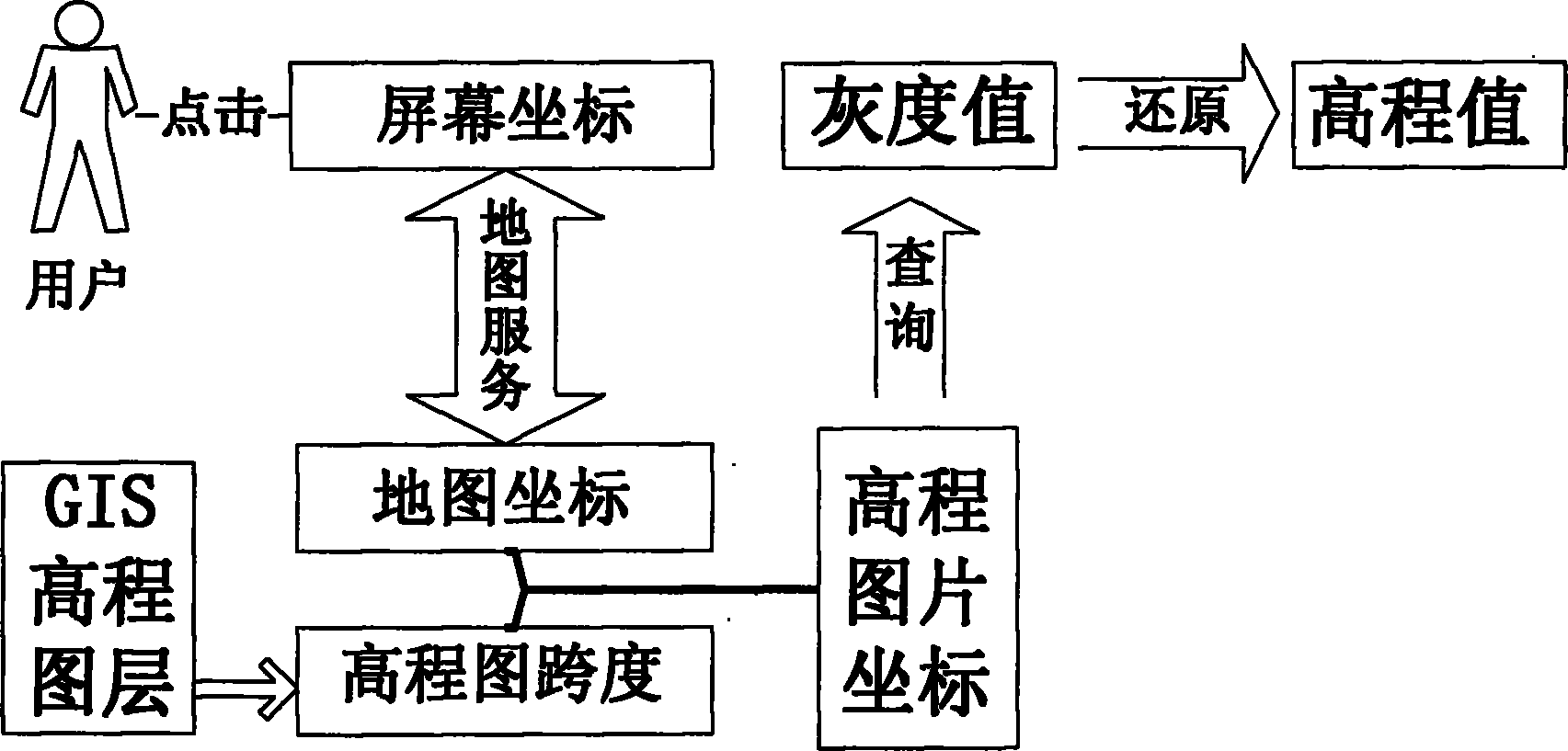
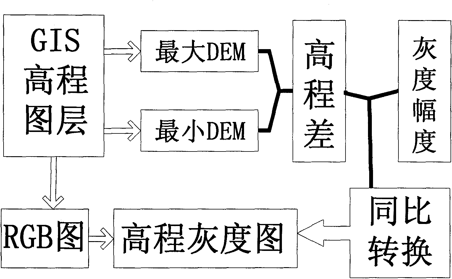
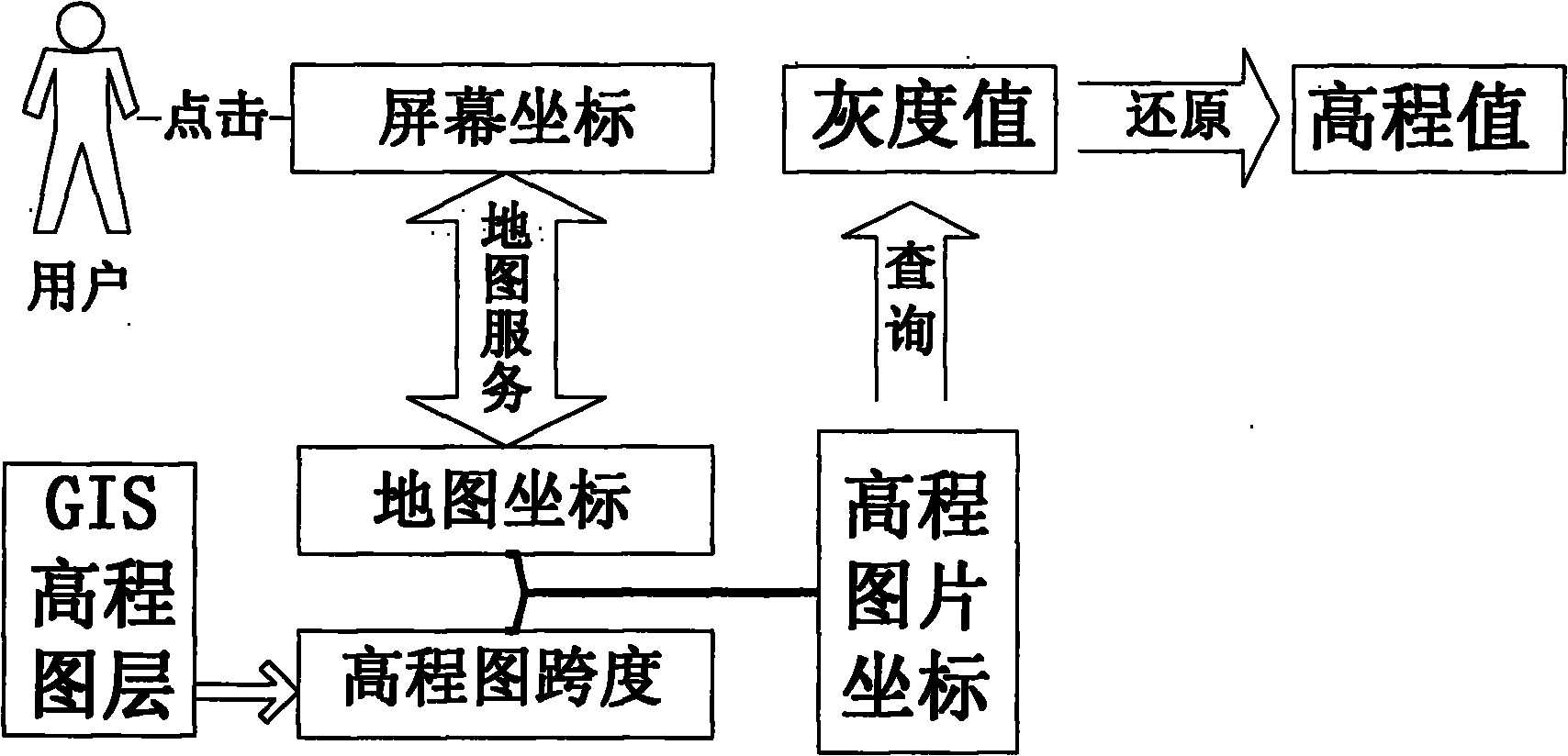
The invention provides a Web GIS (geographic information system)-based elevation geographic data querying system and method. The method is particularly applicable to the fast querying function to elevation geographic information data in a geographic information application system. The system at least comprises a set of geographic information application system, a set of GIS server, a set of integrated client side system, a set of gray level conversing module and a set of coordinate corresponding module, wherein the geographic information application system is used for offering an all-aspect multi-level geographic information service to a client; the GIS server is used for offering a necessary map service to the application system; the client side system is used for realizing the operation access to the geographic information application system under a Web environment; and the geographic information application system is used for firstly calling the gray level conversing module to convert an elevation rasterized layer offered by the GIS server into an elevation gray level image, calling the coordinate corresponding module to correspond the coordinate when the client needs to query the elevation geographic data of some coordinate point on the map, querying the gray level of the corresponding coordinate, and restoring the gray level into an elevation value to be queried according to a gray level conversion rule. The invention can be effectively used for querying the elevation geographic data in various geographic information application systems, and is high in querying efficiency, thereby being particularly applicable to the grid type elevation data such as the height, the depth of water, etc.
Description
A WebGIS-based Elevation Geographical Data Query System and Method technical field The invention provides a WebGIS-based elevation geographic data query system and method, and the method is especially suitable for the fast query function of elevation geographic information data in geographic information application systems. Background technique The geographic information application system has been widely used in all aspects of modern life, the most prominent of which is the electronic map on the Internet, which is also a geographic information application system in essence, and its ultimate development direction is the application for the whole society. Therefore, how to provide more and more user-friendly functions in the geographic information system is a very necessary task, but in the current application system based on WebGIS, it is impossible to use the existing API to achieve the raster map in the GIS server To serve the query function of the elevation information ...
Claims
Login to view more Application Information
Patent Timeline
 IPC IPC(8): G06F17/30
Inventor 黄冬梅张岭何盛琪王健袁小华郑小罗苏诚谢文辉
Owner SHANGHAI OCEAN UNIV
- R&D Engineer
- R&D Manager
- IP Professional
Why Eureka
- Industry Leading Data Capabilities
- Powerful AI technology
- Patent DNA Extraction
Try Eureka
Browse by: Latest US Patents, China's latest patents, Technical Efficacy Thesaurus, Application Domain, Technology Topic.
© 2024 PatSnap. All rights reserved.Legal|Privacy policy|Modern Slavery Act Transparency Statement|Sitemap