Method for automatically matching multisource space-borne SAR (Synthetic Aperture Radar) images based on RFM (Rational Function Model)

A reference image and image technology, applied in the direction of radio wave reflection/re-radiation, using re-radiation, measuring devices, etc., can solve problems such as increasing computational complexity, limiting detection of wrong matches, and poor matching reliability, to achieve solution Convenience, simple form, reliable and precisely matched effects

Active Publication Date: 2011-10-12
CCCC SECOND HIGHWAY CONSULTANTS CO LTD
View PDF0 Cites 51 Cited by
  • Summary
  • Abstract
  • Description
  • Claims
  • Application Information

AI Technical Summary

Problems solved by technology

[0005] 1) The strict geometric model involves more physical parameters, and the strict geometric models of multi-source images are different, which increases the complexity of calculation;
[0006] 2) For the case of non-dense point matching, the compatibility constraint is based on the assumption that adjacent points have the same or similar disparity, which greatly limits its ability to find wrong matches
[0007] The block adjustment model based on the RFM model can accurately express the spatial geometric constraint relationship that needs to be satisfied between points with the same name, and can be used to detect and delete wrong matching points. For this reason, the present invention introduces the RFM model into the multi-source spaceborne SAR image In order to solve the problems of low matching success rate and poor matching reliability in the process of obtaining the same name points in multi-source spaceborne SAR images, the RFM model block adjustment is integrated into the matching process of each layer of pyramid

Method used


Image

  • Method for automatically matching multisource space-borne SAR (Synthetic Aperture Radar) images based on RFM (Rational Function Model)
  • Method for automatically matching multisource space-borne SAR (Synthetic Aperture Radar) images based on RFM (Rational Function Model)
  • Method for automatically matching multisource space-borne SAR (Synthetic Aperture Radar) images based on RFM (Rational Function Model)

Examples


Embodiment 1

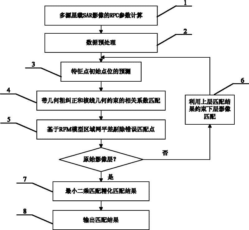
[0024] The present invention will be described in further detail below in conjunction with the accompanying drawings. An RFM model-based automatic multi-source spaceborne SAR image matching method, each step is described in detail as follows:

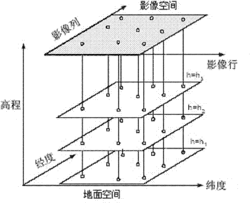
[0025] Step 1 RPC parameter calculation 1 of multi-source spaceborne SAR images:

[0026] Using a terrain-independent method (refer to "High Resolution Remote Sensing Satellite Application—Imaging Model, Processing Algorithm and Application Technology" by Zhang Yongsheng, Gong Danchao, etc.), using the strict geometric model of spaceborne SAR images, and generating them based on different elevation surfaces A dense and uniformly distributed virtual control grid, such as figure 1 As shown in , the RPC parameters of each image are obtained by using virtual control points to solve according to the principle of least squares.

[0027] Step 2 data preprocessing 2:

[0028] Step 2.1 Pyramid image generation: Use a practical and simple 3×3 ...


PUM


Abstract

The invention discloses a method for automatically matching multisource space-borne SAR (Synthetic Aperture Radar) images based on an RFM (Rational function model). The method comprises the following steps of: calculating respective RPC (Rational Polynominal Coefficient) parameter of images; performing forecast of initial positions of points to be matched, matching of approximate epipolar line geometric establishment constraints and geometric rough correction of matched window images by using the RPC parameters of the images on every pyramid image layer, deleting wrong matching points from the image matching result of every layer of pyramid by adopting regional computer network error compensation based on an RFM model; refining the RPC parameters of the images and calculating the object space coordinates of the matching points; refining the matching result to the original image layer by layer; and refining a matching result by using a least square image matching method to realize automatic and reliable matching of common points of multisource space-borne SAR images. In the method, the RFM model is introduced into automatic matching of the multisource space-borne SAR images, and the regional computer network error compensation of the RFM model is blended into the image matching process of every layer pyramid, so that wrong matching points in the matching process can be effectively deleted, and the workload of manual measurement of common points is effectively lowered.

Description

technical field [0001] The present invention relates to the technical field of spaceborne synthetic aperture radar (Synthetic Aperture Radar, SAR) image processing, and more specifically to a multi-source spaceborne SAR image automatic matching method based on a rational function model (Rational Function Model, RFM), which can Solve the problem that wrong matching points cannot be effectively deleted during the matching process, and realize automatic and reliable matching of multi-source spaceborne SAR images. Background technique [0002] With the development of SAR sensor technology, it is becoming easier and easier to use multiple SAR sensors to obtain spaceborne remote sensing images of the same area at different times and locations. The joint positioning of targets in multi-source remote sensing images has become an important issue in the field of photogrammetry and remote sensing. One of the research directions. However, whether it is single-point 3D positioning or bl...

Claims


Application Information

Patent Timeline
Patent Type & Authority Applications(China)
IPC IPC(8): G01S13/90
Inventor 明洋陈楚江吴颖丹余绍淮张霄王丽园李海亮
Owner CCCC SECOND HIGHWAY CONSULTANTS CO LTD
Why Eureka
Try Eureka