Matching method of homonym points in heterogeneous remote sensing images considering high-order structural features

A technology of structural features and remote sensing images, applied in the field of surveying and mapping science, can solve problems such as narrowing the matching search space

Active Publication Date: 2019-06-14
HUBEI UNIV OF TECH
View PDF2 Cites 0 Cited by
  • Summary
  • Abstract
  • Description
  • Claims
  • Application Information

AI Technical Summary

Problems solved by technology

However, the focus of its research is to integrate the beam block adjustment method based on the RFM model into the same-name point matching process, use the geometric constraints provided by the RFM model, improve the prediction accuracy of the initial point position of the feature points, and provide epipolar line geometric constraints to narrow the matching The search space and the block adjustment based on the RFM model eliminate the wrong matching points, but it is still a single-point matching in essence, and the high-order structural features between the matching points are not introduced in the matching process

Method used


Image

  • Matching method of homonym points in heterogeneous remote sensing images considering high-order structural features
  • Matching method of homonym points in heterogeneous remote sensing images considering high-order structural features
  • Matching method of homonym points in heterogeneous remote sensing images considering high-order structural features

Examples


Embodiment 1

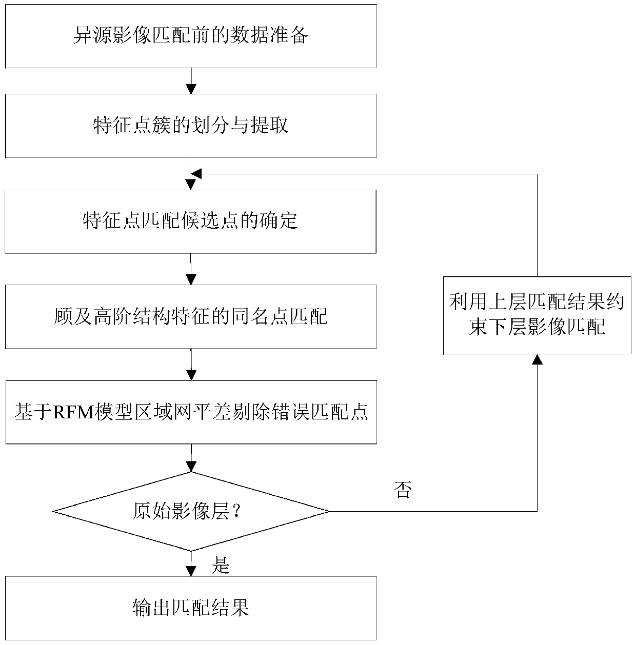
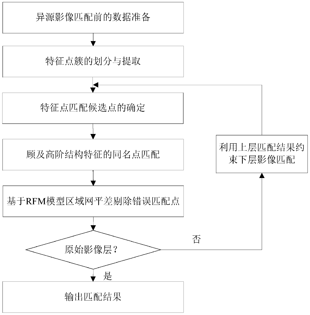
[0058] see figure 1 , the present invention provides a method for matching homonymous points of heterogeneous remote sensing images in consideration of high-order structural features, and each step is described in detail as follows:

[0059] Step 1) Data preparation before heterogeneous image matching:

[0060] Data preparation before heterogeneous image matching mainly includes:

[0061] 1) Calculating the RPC parameters of heterogeneous remote sensing images: This step is optional and can only be performed when the remote sensing images only provide a strict geometric model. Using a terrain-independent method (refer to "High Resolution Remote Sensing Satellite Application—Imaging Model, Processing Algorithm and Application Technology" by Zhang Yongsheng, Gong Danchao, etc.), using the strict geometric model of the image, the dense and Uniformly distributed virtual control grid, using virtual control points to solve according to the principle of least squares, to obtain the...


PUM


Abstract

The invention belongs to the field of surveying and mapping science and technology, and provides a method for matching points of the same name in heterogeneous remote sensing images in consideration of high-order structural features, including data preparation before heterogeneous image matching; dividing and extracting feature point clusters; feature points Determination of candidate matching points; matching of points with the same name in consideration of high-order structural features; for each layer of pyramid image matching results, using the RFM model block adjustment method of fusion weight selection iterative method; refining the matching results layer by layer until the original image layer is completed , and finally realize automatic and reliable matching of homonymous points in heterogeneous remote sensing images. The present invention comprehensively uses the rational function model and the hypergraph image matching model, and introduces geometric constraint features and high-order structural features into layer-by-layer pyramid image matching, which not only ensures the sparsity of the hypergraph model, but also makes the hyperedge sampling The information loss is minimized; the invention improves the reliability and success rate of heterogeneous remote sensing image matching, and effectively reduces the workload of manual measurement of points with the same name.

Description

technical field [0001] The invention belongs to the field of surveying and mapping science and technology, and relates to a method for matching homonymous points of heterogeneous remote sensing images, in particular to a method for matching homonymous points of heterogeneous remote sensing images in consideration of high-order structural features. Background technique [0002] With the rapid development of earth observation technology, various types of sensors have sprung up. They record the changes of the earth's surface with higher time resolution and spatial resolution, and also make the images covering the same area more and more diverse. . The joint target positioning of heterogeneous remote sensing images has become one of the important research directions in the field of photogrammetry and remote sensing. However, whether it is single-point 3D positioning or block adjustment, it is necessary to quickly and accurately find the same name point of the image and measure ...

Claims


Application Information

Patent Timeline
Patent Type & Authority Patents(China)
IPC IPC(8): G06K9/62G06K9/00
CPCG06V20/13G06V10/757
Inventor 吴颖丹明洋黄楚云吕辉田德生雷勇谭焓
Owner HUBEI UNIV OF TECH
Why Eureka
Try Eureka