
Method of autonomous drawing and transmission by utilizing GPS and mobile terminal thereof

A mobile terminal and motion trajectory technology, applied in the field of autonomous drawing and transmission, can solve the problem that GPS equipment cannot draw autonomously, and achieve the effect of fast update speed

Inactive Publication Date: 2011-11-09
沈阳新邮通信设备有限公司
View PDF5 Cites 15 Cited by
  • Summary
  • Abstract
  • Description
  • Claims
  • Application Information

AI Technical Summary

Problems solved by technology

[0003] The technical problem to be solved by the present invention is to provide a method for autonomously drawing and transmitting using GPS and a mobile terminal to overcome the defect that GPS equipment cannot draw independently in the prior art

Method used


Image

  • Method of autonomous drawing and transmission by utilizing GPS and mobile terminal thereof
  • Method of autonomous drawing and transmission by utilizing GPS and mobile terminal thereof
  • Method of autonomous drawing and transmission by utilizing GPS and mobile terminal thereof

Examples


Embodiment Construction

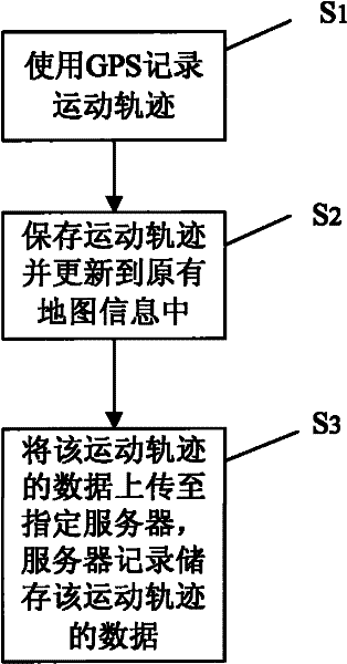
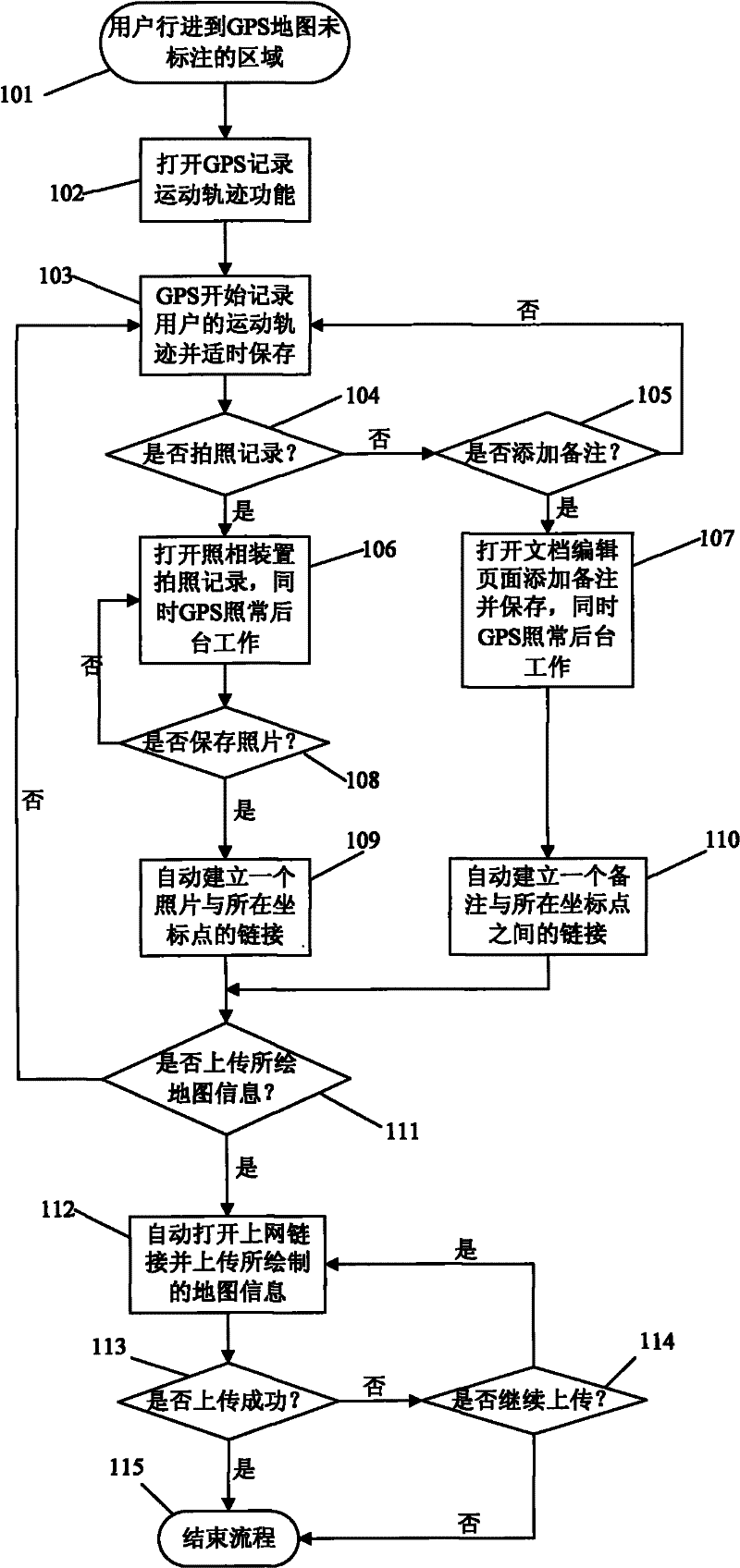
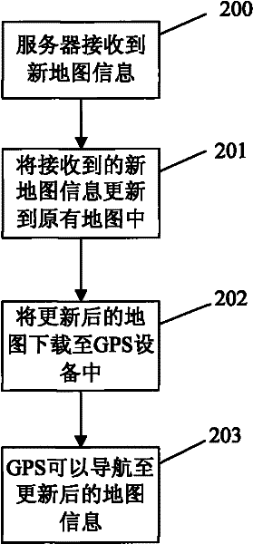
[0034] The preferred embodiments of the present invention are given below in conjunction with the accompanying drawings to describe the technical solution of the present invention in detail. refer to figure 1 , the method for autonomously drawing and transmitting using GPS according to the present invention comprises the following steps: S 1 : Use GPS to record the movement track; S 2 : save the motion track, and update the data of the motion track to the GPS map information; S 3 : Upload the data of the movement track to the designated server, and the server records and stores the data of the movement track. GPS recording motion track can be timely recording motion track. For step S 1 The current GPS devices basically have the function of recording the movement track in a timely manner. For step S 2 Depending on the map library that the GPS matches, there are different methods of operation. Method I: For maps that allow users to mark and compile (such as GOOGLE satelli...


PUM


Abstract

The invention discloses a method of autonomous drawing and transmission by utilizing GPS. The method comprises the following steps: S1. using GPS to record a movement track; S2. preserving the movement track and updating data of the movement track to GPS map information; S3. uploading the data of the movement track to an assigned server which records and stores the data of the movement track. The invention also discloses a mobile terminal of autonomous drawing and transmission by utilizing the above method. According to the method of autonomous drawing and transmission by utilizing GPS, a rescue team is helped to discover a movement route and position of outdoor exploration victims. The method is contributed to record a valuable object found in the wild lest the object can not be found again because of complex field environment, the method also is contributed to help GPS map providers to updating map.

Description

technical field [0001] The invention relates to a method for autonomous drawing and transmission by using GPS, in particular to a method for realizing autonomous drawing and transmission by using GPS and a camera on a mobile phone. Background technique [0002] Now more and more people are interested in wild adventures, especially in some undeveloped original wild areas, such as deep mountains, islands, caves and so on. However, many explorers encounter accidents every year, and the best rescue time is lost because they cannot be found in time during search and rescue. The map equipped with the current GPS basically does not mark the information of the wilderness area in detail. Although the satellite map provided by GOOGLE can provide panoramic photos, it has little guiding effect for explorers in the wild jungle. There are also many people who appear to circle in place because they lose their way in the jungle. In addition, the valuable information discovered by outdoor...

Claims


Application Information

Patent Timeline
Patent Type & Authority Applications(China)
IPC IPC(8): G01C21/30G01C21/32G01S19/01H04M1/725H04M1/72457
Inventor 方琼林
Owner 沈阳新邮通信设备有限公司
Learn More