Improved NCS (Nonlinear Chirp Scaling) imaging algorithm suitable for geosynchronous orbit (GEO) SAR (Synthetic Aperture Radar)

A geosynchronous orbit, imaging technology, applied in the direction of using re-radiation, reflection/re-radiation of radio waves, measurement devices, etc., can solve the problems of short synthetic aperture time, long equivalent linear model, failure and so on

Inactive Publication Date: 2012-01-25
BEIJING INSTITUTE OF TECHNOLOGYGY
View PDF0 Cites 18 Cited by
  • Summary
  • Abstract
  • Description
  • Claims
  • Application Information

AI Technical Summary

Problems solved by technology

[0003] The current SAR imaging algorithms are all established based on low-orbit (LEO) conditions. The disadvantages are: LEO SAR generally has a relatively short synthetic aperture time, and the trajectory of satellite flight can be approximated by an equivalent straight line model, but the synthetic aperture time in GEO SAR Generally, it reaches hundreds of seconds, so the equivalent linear model relied on by the low-orbit SAR imaging algorithm is invalid due to the long aperture time of GEO SAR
The NCS algorithm is an excellent large-scene imaging algorithm, but it is based on the equivalent straight line model, so it is difficult to be directly applied to GEO SAR

Method used


Image

  • Improved NCS (Nonlinear Chirp Scaling) imaging algorithm suitable for geosynchronous orbit (GEO) SAR (Synthetic Aperture Radar)
  • Improved NCS (Nonlinear Chirp Scaling) imaging algorithm suitable for geosynchronous orbit (GEO) SAR (Synthetic Aperture Radar)
  • Improved NCS (Nonlinear Chirp Scaling) imaging algorithm suitable for geosynchronous orbit (GEO) SAR (Synthetic Aperture Radar)

Examples


Embodiment

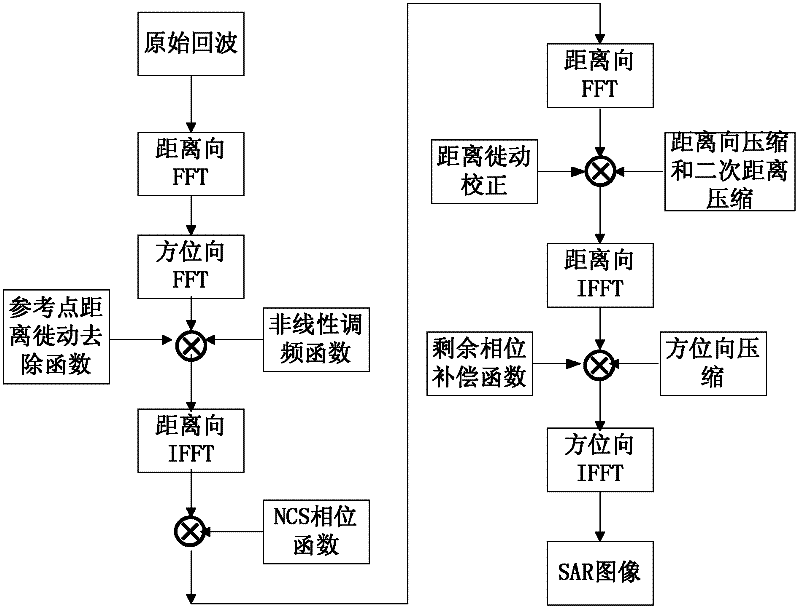
[0100] The radar flies at a certain speed in a geosynchronous orbit, transmits chirp signals to the ground, and receives echoes from the ground. Perform imaging processing on the obtained echoes, and propose an improved NCS algorithm suitable for GEO SAR. The specific steps are as follows: figure 1 shown, including:

[0101] 1) The target echo received by the radar

[0102] Radar transmits a carrier frequency f c linear frequency modulation signal. After demodulating the received echo, we can get

[0103] s ( t r , t a ) = u r ( t r - 2 · R n c ) · ...


PUM


Abstract

The invention relates to an improved NCS (Nonlinear Chirp Scaling) imaging algorithm suitable for a geosynchronous orbit (GEO) SAR (Synthetic Aperture Radar), belonging to the technical field of SAR imaging. The NCS imaging algorithm is improved by establishing a curved locus signal model for replacing an equivalent linear model in an original NCS imaging algorithm and evaluating a two-dimensional resolving spectrum expression suitable for the NCS imaging algorithm on the basis of the established curved locus signal model. Compared with the prior art, the improved NCS imaging algorithm has the advantages that: a novel curved locus model suitable for the GEO SAR is obtained with a high-order Taylor expansion method, and the defects of large error of a near equivalent linear model, completely unavailable application of a far equivalent linear model and the like of the GEO SAR can be overcome by adopting the locus model; and meanwhile, a two-dimensional resolving spectrum suitable for the NCS algorithm is obtained on the basis of the equivalent linear model, and various compensation functions of the NCS algorithm can be resolved by using the spectrum, so that the requirement on large-scene imaging of the GEO SAR is met.

Description

technical field [0001] The invention relates to an improved NCS imaging algorithm, in particular to an improved NCS imaging algorithm suitable for geosynchronous orbit (GEO) SAR, and belongs to the technical field of synthetic aperture radar (SAR) imaging. Background technique [0002] The current SAR satellites are all low-orbit satellites, with an orbital height of no more than 1,000km. The repeated observation period for a specific area is generally 3 to 5 days, and at least 1 day is required for orbital maneuvering; therefore, the existence of low-orbit SAR Low resolution and long lag time to respond to emergencies. An effective method to solve this problem is a geosynchronous orbit synthetic aperture radar (GEO SAR) satellite, which is a SAR satellite operating in a geosynchronous orbit at a height of 36,000km; this geosynchronous orbit is not a geostationary orbit, and it has certain Inclination angle, its sub-satellite point trajectory is in the shape of '8', so that...

Claims


Application Information

Patent Timeline
Patent Type & Authority Applications(China)
IPC IPC(8): G01S13/90
Inventor 龙腾胡程刘志鹏朱宇
Owner BEIJING INSTITUTE OF TECHNOLOGYGY
Why Eureka
Try Eureka