Interactive traffic navigation method based on wireless communication network and system

A technology of wireless communication network and navigation method, which is applied in the traffic control system of road vehicles, traffic control system, road network navigator, etc., and can solve the problem of prolonged vehicle driving time, unsatisfactory navigation path, lack of traffic road condition information input and information Two-way interaction and other issues to achieve the effect of improving adaptability and real-time performance

Inactive Publication Date: 2012-04-04
叶朝晖
View PDF6 Cites 31 Cited by
  • Summary
  • Abstract
  • Description
  • Claims
  • Application Information

AI Technical Summary

Problems solved by technology

[0008] The technical problem to be solved by the present invention is aimed at the prior art. In the traffic navigation process, the vehicle only performs the coordinate positioning or position query of the vehicle, and at the same time, it can only plan the shortest driving route from the perspective of the vehicle itself, and lacks the traffic road condition information in the area. The two-way interaction between input and information leads to the unsatisfactory navigation path provided and the inability to effectively avoid traffic jams, resulting in prolonged vehicle driving time and failing to meet the requirements of driving travel. An interactive traffic navigation method based on wireless communication network is provided. and systems to improve the efficiency of traffic management and the rationality of navigation routes

Method used


Image

  • Interactive traffic navigation method based on wireless communication network and system
  • Interactive traffic navigation method based on wireless communication network and system
  • Interactive traffic navigation method based on wireless communication network and system

Examples


Embodiment

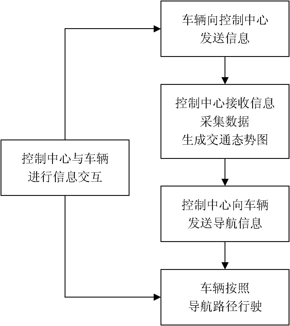
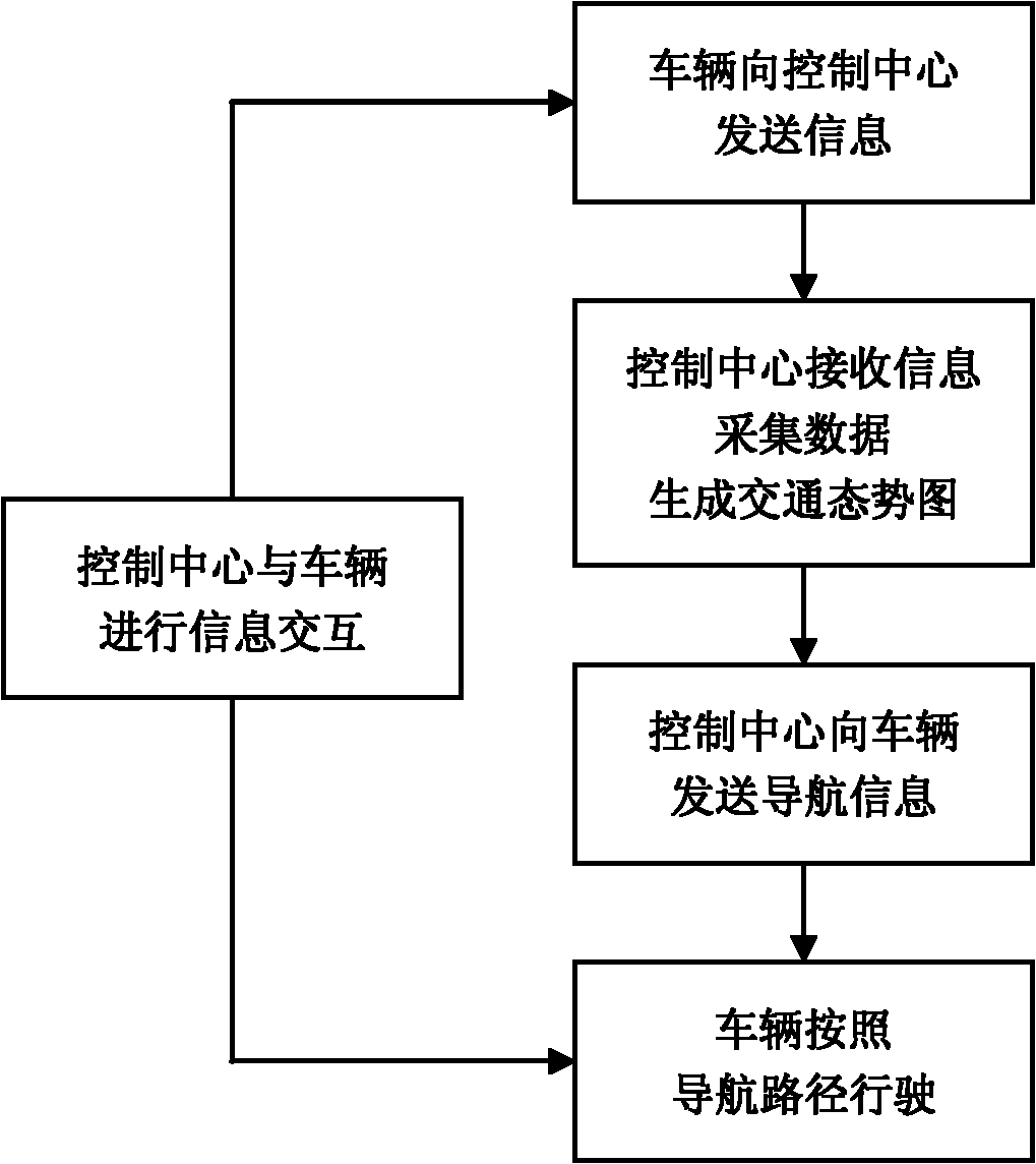
[0039] The steps of the interactive traffic navigation method based on the wireless communication network of this example are as follows: figure 1 shown, including:

[0040] In the first step, the vehicle obtains the real-time coordinates of the vehicle through joint positioning of the GPS system and the wireless communication network, and sends its real-time position coordinates and destination coordinates to the control center.

[0041] In the second step, the control center marks the received position coordinates of each vehicle on the electronic map, and establishes a regional vehicle dynamic distribution map in combination with the traffic road condition information it collects. The traffic information collected by the control center refers to other traffic information other than the location coordinates transmitted by the vehicle, such as the distribution density of road vehicles collected by the Skynet system and the traffic information released by relevant departments....


PUM


Abstract

The invention relates to traffic navigation technology, and discloses an interactive traffic navigation method based on a wireless communication network and a system, which aims to overcome shortcomings that the prior art is lack of input of traffic road condition information in a region and bidirectional information interaction during traffic navigation, accordingly, navigation paths are not ideal, traffic jam sections cannot be effectively avoided, travel time of vehicles is prolonged, and the requirement of travel by driving cannot be met. By the aid of the interactive traffic navigation method and the system, traffic management efficiency and reasonableness of navigation paths are improved. The interactive traffic navigation method and the system are based on current mature technology or technology which is already applied, and realize visual display of road traffic conditions for drivers of vehicles, forward jam sections can be avoided as much as possible by means of dynamic comparison and optimization of various driving paths from the current location to a destination of a vehicle, a part of a vehicle flow is properly dynamically split according to time sequence of arrival time to a certain place of vehicles in the same direction, optimal driving paths of the vehicles are scientifically planned, accordingly, traffic participation initiative of the drivers of the vehicles is effectively improved, and the purpose of dynamic and intelligent traffic navigation is realized.

Description

technical field [0001] The invention relates to traffic navigation technology, in particular to an interactive traffic navigation method and system based on GPS and wireless communication network. Background technique [0002] With the rapid development of my country's economy, the number of family cars is increasing day by day. By the end of 2009, the number of motor vehicles in the country has exceeded 180 million, of which the number of cars is close to 80 million. Since the speed of domestic urban road construction is far behind the growth of the number of motor vehicles, the traffic pressure has increased rapidly, and road traffic congestion has become the number one problem people encounter when traveling by car. Traffic congestion brings not only the time loss of traffic participants, but also the chaos of traffic order will further aggravate the congestion situation, affect the driver's mood, and cause the increase of traffic accidents; more importantly, frequent con...

Claims


Application Information

Patent Timeline
Patent Type & Authority Applications(China)
IPC IPC(8): G08G1/0968G01C21/34
Inventor 叶朝晖
Owner 叶朝晖
Why Eureka
Try Eureka