Automatic registration method of airborne laser point cloud and aerial image

A technology of aerial imagery and airborne laser, which is applied in image analysis, image data processing, instruments, etc., can solve the problem of lower registration accuracy, lower laser point cloud data accuracy, and differences in data acquisition mechanisms between laser point cloud and aerial imagery And other issues

Active Publication Date: 2012-04-11
WUHAN UNIV
View PDF1 Cites 61 Cited by
  • Summary
  • Abstract
  • Description
  • Claims
  • Application Information

AI Technical Summary

Problems solved by technology

[0004] One of the purposes of the present invention is to solve the problem that the laser point cloud needs to be interpolated into a point cloud image when registering the laser point cloud and the aerial image in the prior art, which reduces the accuracy of the laser point cloud data and thus reduces the registration accuracy
[0005] The second purpose of the present invention is to solve the problem that it is quite difficult to automatically extract and match the features of the same name between the two data due to the huge difference in the acquisition mechanism of the laser point cloud and the aerial image; provide An automatic registration method of airborne laser point cloud and aerial image

Method used


Image

  • Automatic registration method of airborne laser point cloud and aerial image
  • Automatic registration method of airborne laser point cloud and aerial image
  • Automatic registration method of airborne laser point cloud and aerial image

Examples


Embodiment

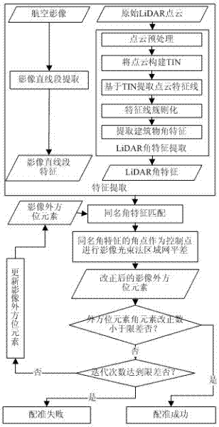
[0045] An automatic registration method of airborne laser point cloud and aerial image, as attached figure 1 shown, including the following steps:

[0046] 1. In step 1, the feature extraction of the straight line segment of the image is performed on each aerial image; and then the point cloud angle feature is extracted in the laser point cloud;

[0047] First, feature extraction of the straight line segment of the image is performed, and the straight line edge of the building is detected and extracted through the Canny operator. The specific method is as follows:

[0048] Step 1.1.1, using the existing edge detection operator Canny operator to process the aerial image, the edge features on the image can be obtained, and each edge is composed of a series of connected edge pixels;

[0049] Step 1.1.2, for the edges extracted in the previous step, each edge is tracked according to the connectivity of the edge points, and a separate edge line is obtained;

[0050] Step 1.1.3, ...


PUM


Abstract

The invention provides an automatic registration method of an airborne laser point cloud and an aerial image. The automatic registration method comprises the following steps of: extracting a building outline from the point cloud without interpolation for the laser point cloud; obtaining building angular characteristics as a registration element through outline regularization; automatically matching the point cloud with the image according to the homonymic angular characteristics with the aid of an approximate exterior orientation element of the aerial image; and utilizing bundle block adjustment and a cyclic iterative policy so as to realize overall optimal registration of aerial image and point cloud data. The registration method provided by the invention has the following advantages that: the building outline is directly extracted from the laser point cloud without interpolation for the laser point cloud so as to obtain the building angular characteristics as the registration element, which prevents interpolation errors and improves the registration accuracy; and the exterior orientation element of the image is solved by virtue of bundle block adjustment, and meanwhile overall optimal registration between the aerial image and the airborne laser point cloud is realized by adopting the cyclic iterative registration policy.

Description

technical field [0001] The invention relates to a multi-source data registration method, in particular to an automatic registration method of an airborne laser point cloud and an aerial image. Background technique [0002] Airborne Laser Detection and Ranging (Airborne LiDAR) is an important technology for rapid acquisition of terrain data, and has become an important means of urban 3D information acquisition. Current airborne LiDAR systems are usually equipped with digital cameras that acquire high-resolution color aerial imagery alongside laser point clouds. Due to the strong complementarity between laser point cloud and image data, the integration of the two has a wide range of applications in the fields of road extraction, building extraction and modeling, and orthophoto production. Due to the placement error of the digital camera and other reasons, there are generally large errors in the outer orientation elements of the obtained aerial image, which leads to the inabil...

Claims


Application Information

Patent Timeline
Patent Type & Authority Applications(China)
IPC IPC(8): G06T7/00
Inventor 张永军熊小东沈翔
Owner WUHAN UNIV
Why Eureka
Try Eureka