
Voice broadcast method for crossroad form based crossroad steering information

A technology of voice broadcast and road section information, applied in the field of geographic information system, can solve the problem of not being deep

Active Publication Date: 2013-09-25
SUZHOU MAIPU INFORMATION TECH
View PDF1 Cites 0 Cited by
  • Summary
  • Abstract
  • Description
  • Claims
  • Application Information

AI Technical Summary

Problems solved by technology

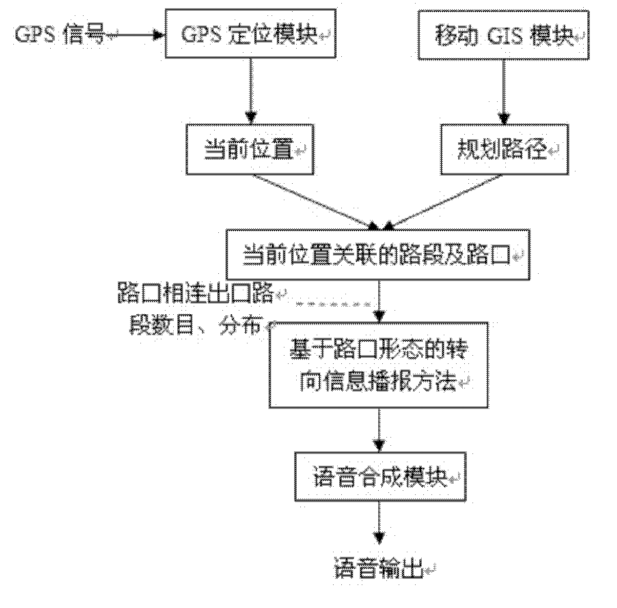
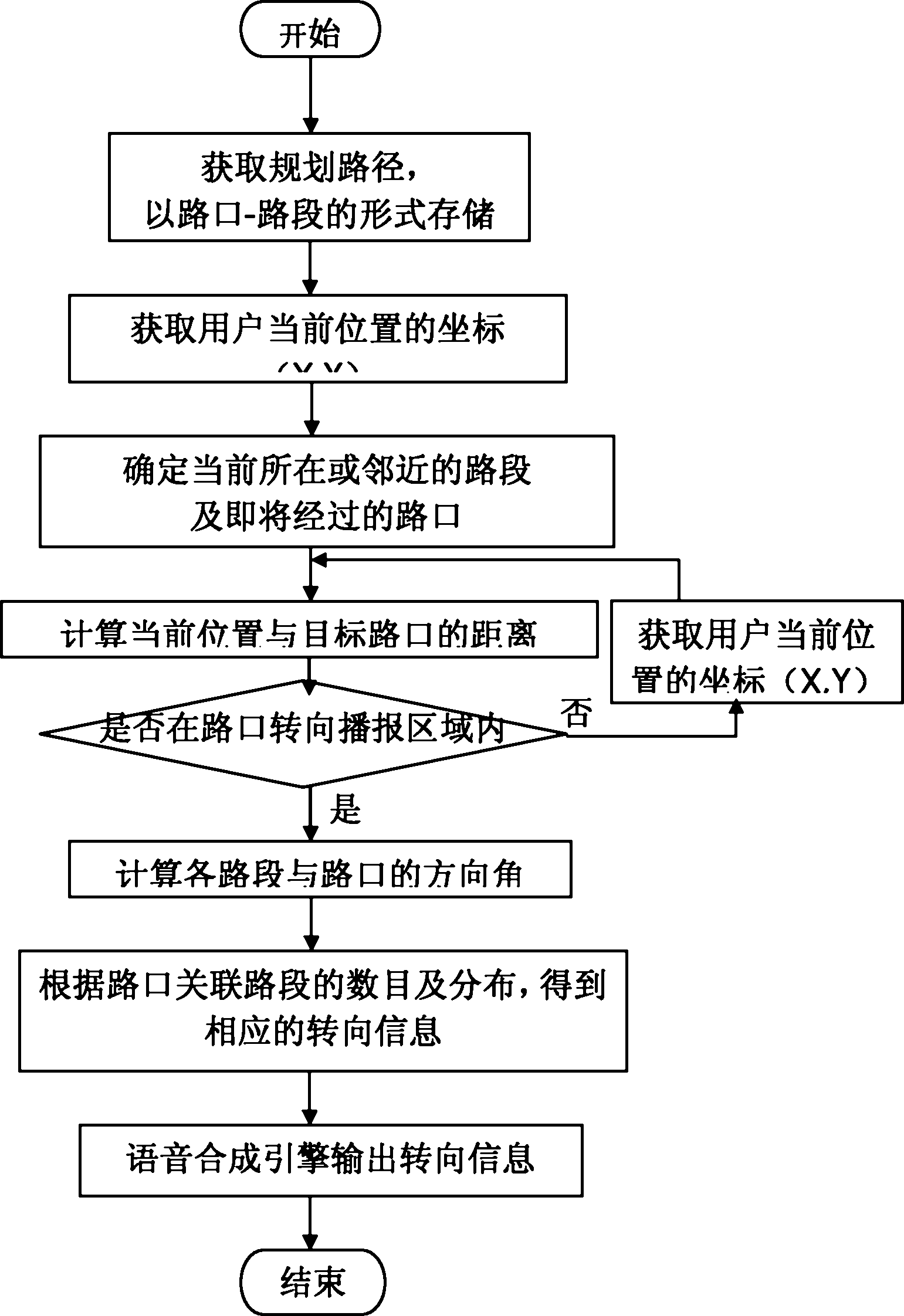
[0004] Aiming at the fact that the current research on the influence of intersection shape on steering information is not in-depth, the present invention proposes a voice broadcasting method of intersection steering information based on intersection shape, which simulates human’s spatial cognitive thinking mode and improves the existing steering information broadcasting model for more explicit steering information

Method used


Image

  • Voice broadcast method for crossroad form based crossroad steering information
  • Voice broadcast method for crossroad form based crossroad steering information
  • Voice broadcast method for crossroad form based crossroad steering information

Examples


Embodiment

[0080] This embodiment takes the application in the audio guide explanation process of the Shanghu Scenic Area in Changshu City, Jiangsu Province as an example. The mobile GIS module is based on the ArcGIS Mobile software of ESRI Company to carry out secondary development; the GPS device of the GPS positioning module is the smartphone. The device uses the GPS interface in ESRI's ArcGIS Mobile software to drive the device to obtain real-time location information of the user; the speech synthesis module uses the speech synthesis engine and its interface of Jietong Huasheng Company.

[0081] The peony tour route in the scenic area is Path[10]={E 10 ,E 13 ,E 17 ,E 22 ,E 26 ,E 27 ,E 31 ,E 32 ,E 43 ,E 52}.

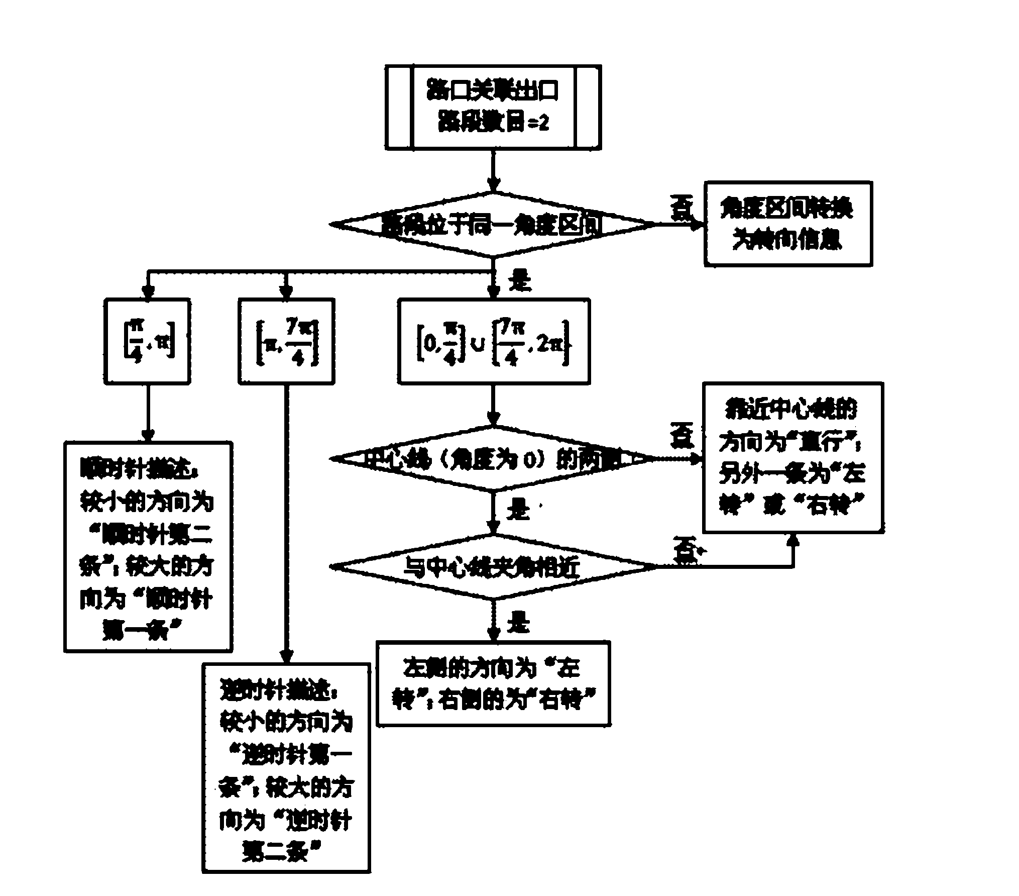
[0082] Case 1, the number of exit road sections is 2, located in the same angle interval:

[0083] The current position coordinates Position (120.684945, 31.642316) obtained by the GPS acquisition module.

[0084] Step 1: Determine the distance from the current locati...


PUM


Abstract

The invention discloses a voice broadcast method for crossroad form based crossroad steering information so as to solve the problem that crossroad steering information in scenic spots and other areas with special crossroad forms is difficult to be broadcast accurately. The method comprises: determining information about a planned route and a user's real-time position through a mobile GIS (geographical information system) module and a GPS (global positioning system) positioning module, acquiring information about a road section that the user is located currently and a crossroad about to enter, calculating the direction angles of associated road sections of the crossroad, conducting crossroad form analysis by combining an exit road section number and distribution situation, converting an analysis result into natural language described texts, which are then broadcast for the user through a speech synthesis engine. The method of the invention can accurately analyze and broadcast crossroad steering information directed at complex road forms.

Description

technical field [0001] The invention relates to a voice broadcast method for turn information at an intersection, and belongs to the technical field of geographic information systems. Background technique [0002] Voice navigation in the mobile environment integrates mobile GIS technology, GPS technology and speech synthesis technology, and is widely used in vehicle navigation, smart tourism, public services and other fields. Mobile navigation technology uses a relative spatial reference frame, that is, uses the user's "front", "back", "left" and "right" orientations, and uses the "clockwise" and "counterclockwise" description systems for turntable intersections as the basis for steering information. Descriptive vocabulary, on this basis, ensure that the description language is accurate, simple and easy to understand. At present, research on papers, patents and products related to turning information at intersections mainly focuses on two aspects: one is the data modeling o...

Claims


Application Information

Patent Timeline
Patent Type & Authority Patents(China)
IPC IPC(8): G01C21/34
Inventor 龙毅郑玥余明朗
Owner SUZHOU MAIPU INFORMATION TECH
Learn More