
Satellite inertial navigation method

An inertial navigation and satellite technology, applied in the field of satellite inertial navigation, can solve the problem that navigation equipment cannot locate and navigate

Active Publication Date: 2015-07-22
HUIZHOU DESAY SV AUTOMOTIVE
View PDF5 Cites 0 Cited by
  • Summary
  • Abstract
  • Description
  • Claims
  • Application Information

AI Technical Summary

Problems solved by technology

In the blind area of ​​satellite positioning, the navigation equipment cannot locate and navigate because it cannot receive satellite signals

Method used


Image

  • Satellite inertial navigation method
  • Satellite inertial navigation method
  • Satellite inertial navigation method

Examples


Embodiment Construction

[0043] The satellite inertial navigation device and method of the present invention will be further described in detail below in conjunction with specific embodiments and accompanying drawings.

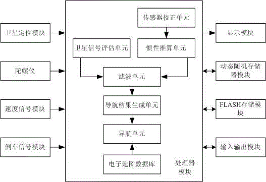
[0044] Satellite inertial navigation method of the present invention is based on such as figure 1 Satellite inertial navigation equipment shown. The satellite inertial navigation equipment can be used as an independent vehicle or airborne navigation equipment, and can also be used as a part of a large navigator positioning system.

[0045] The satellite inertial navigation device mainly includes a satellite positioning module, a gyroscope, a speed signal module, a reversing signal module, a processor module, a display module, a memory and an input and output module.

[0046]The satellite positioning module can be selected from Beidou satellite positioning module, GPS satellite positioning module, European Galileo satellite positioning module, Beidou-GPS dual-mode satellite positionin...


PUM


Abstract

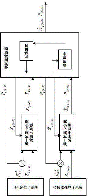
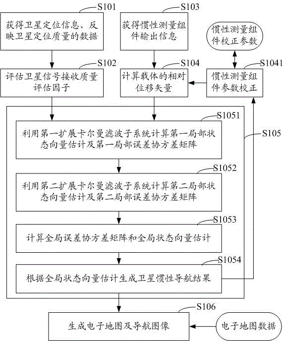
The invention relates to a satellite inertial navigation method, which comprises the steps of using a satellite positioning module to obtain the satellite positioning information of a carrier and data which reflects satellite positioning quality; using an inertial measuring component to obtain the relative displacement vector of the carrier; calculating a signal receiving quality evaluation factor according to the data which reflects the satellite positioning quality; establishing extended Kalman filtering systems and fusing the satellite positioning information and the relative displacement vector according to the evaluation factor to obtain a satellite inertial navigation result; and displaying an electronic map and a navigation image on a display according to the satellite inertial navigation result and electronic map data. By using the satellite inertial navigation method provided by the invention, satellite inertial navigation equipment is enabled to realize partial acceptance or full acceptance of inertial reckoning of signals of the inertial measuring component in areas with poor satellite signal quality or satellite positioning dead zones according to the satellite signal receiving quality evaluation factor, and therefore the continuous updating of navigation information and the accuracy of positioning information can be guaranteed.

Description

technical field [0001] The invention relates to a navigation device and a navigation method, in particular to a satellite inertial navigation device and a navigation method thereof. Background technique [0002] Navigation equipment is widely used on road motor vehicles. Navigation equipment generally provides motor vehicles with route guidance from the origin to the destination based on satellite positioning signals and electronic maps. In high-rise densely populated areas, tunnels and other environments, due to signal multi-path interference and greater signal occlusion, satellite signals will become weak or even unable to receive satellite signals, so these places are called satellite positioning blind spots. In the blind area of ​​satellite positioning, the navigation equipment cannot locate and navigate because it cannot receive satellite signals. Contents of the invention [0003] Based on this, it is necessary to provide a satellite inertial navigation method that...

Claims


Application Information

Patent Timeline
Patent Type & Authority Patents(China)
IPC IPC(8): G01C21/16G01S19/47
Inventor 杜孙正
Owner HUIZHOU DESAY SV AUTOMOTIVE
Learn More