Quick topographic map making method based on database driving

A database and topographic map technology, applied in the direction of electrical digital data processing, special data processing applications, instruments, etc., can solve the problems of low cartography production efficiency, low degree of automation, and complicated conversion work

Inactive Publication Date: 2012-11-28
NAT GEOMATICS CENT OF CHINA
View PDF0 Cites 34 Cited by
  • Summary
  • Abstract
  • Description
  • Claims
  • Application Information

AI Technical Summary

Problems solved by technology

[0004] However, in the update project of the basic geographic information database, it generally focuses on the update of orthophoto data, topographic element data, and digital elevation model data, while ignoring the simultaneous update of paper topographic maps and topographic map mapping data, resulting in a series of Scale topographic maps are generally outdated and cannot meet the needs of applications, especially the needs of national emergency surveying and mapping support
[0005] 2) Existing topographic map mapping technology is difficult to meet the needs of rapid updates
[0006] At present, the production of topographic maps in my country's surveying and mapping industry generally adopts two types of technical methods: one is to use two-dimensional graphics production software to produce topographic maps, and convert topographic data to two-dimensional graphics production software systems, such as CorelDraw, Illustrator, etc., after mapping configuration Generate graphics files, and then edit graphics. The software system graphics editing function used in this method is relatively powerful, but the topographic data is stored in the GIS system, which cannot be directly input during cartography production. The conversion work is more complicated, and the conversion has multiple attributes. It is more difficult to extract elements, and some information may even be difficult to convert and be lost; cartography configuration adopts human-computer interaction, which has a low degree of automation and a large workload. The produced cartographic data and terrain data are strictly separated without geographic coordinates. changes, the two sets of data need to be modified and updated separately
The second method is to use mapping systems that support GIS, such as MapCAD, MicroStation, AutoCAD, etc. They can directly input terrain data files for symbolic configuration and editing, and generate another set of framed graphic data, but they cannot also create two sets of data The close relationship of the database cannot form an integrated storage management database
[0007] Due to the differences in the data models of topographic data and cartographic data, there is still a lack of systematic and effective solutions to the problem of surface element representation conflicts and relationship contradictions caused by the conversion of GIS data to cartographic data models, and it is difficult to realize map symbol configuration and annotation. The production efficiency of the above two methods is relatively low due to the automation and intelligence of the generation, and it is difficult to achieve rapid mapping and the simultaneous update of mapping data and terrain data

Method used


Image

  • Quick topographic map making method based on database driving
  • Quick topographic map making method based on database driving
  • Quick topographic map making method based on database driving

Examples


Embodiment Construction

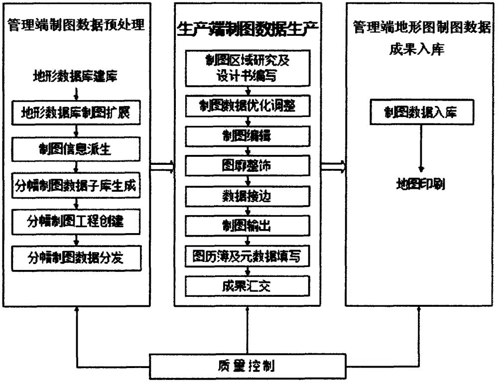
[0070] Such as figure 1 As shown, the database-driven topographic map rapid mapping method of the present invention comprises the following steps

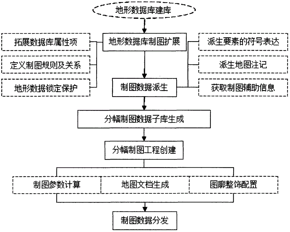
[0071] (1) Preprocessing of mapping data at the management end: topographic database construction: such as figure 2 As shown, it includes the preprocessing of cartographic data before distribution and the collection and storage of edited cartographic data results, that is, the transformation of 1:50000 topographic update data into geographic information data containing cartographic expression information. After the editing of the framing mapping data is completed, the management end needs to be responsible for the centralized storage of the result data, and finally build a topographic mapping database that meets the printing requirements. It mainly includes the following drawing links:

[0072] ① Topographic database mapping extension

[0073] According to the design of the mapping data model of the 1:50000 terrain database, t...


PUM


Abstract

The invention provides a quick topographic map making method based on database driving. Topographic maps of corresponding plotting scales are quickly made by a built topographic database, and a map making database and the topographic database are subjected to integrated storage, integrated management and synchronous updating. The quick topographic map making method based on database driving comprises the following steps of: (1) preprocessing map making data at a management end, namely building the topographic database, expanding the map making function of the topographic database, deriving map making data, generating framing map making sub databases, and establishing framing map making engineering; (2) generating the map making data at a production end, namely optimizing and adjusting the map making data, editing map making, trimming the contour of a map, edging the data and outputting the map; and (3) putting the topographic map making data into the database at the management end, namely concentratively performing uniform data storage processing on the topographic map making data subjected to the map making production steps such as map making editing, inspection and accepting, and forming the final topography and map-making integrated database.

Description

technical field [0001] The invention relates to a topographic map drawing method, in particular to a database-driven topographic map rapid drawing method. Background technique [0002] 1) my country's basic scale topographic maps are outdated and urgently need to be updated [0003] With the gradual establishment and improvement of the informational surveying and mapping system, my country has completed the construction of basic geographic information databases with basic scales such as 1:1 million, 1:250,000, and 1:50,000, and the 1:50,000 database update project is about to be fully completed. . At the same time, local surveying and mapping departments have also established provincial-level basic geographic information databases with a scale of 1:10,000 and larger, and have carried out 1-2 rounds of data updates. [0004] However, in the update project of the basic geographic information database, it generally focuses on the update of orthophoto data, topographic element ...

Claims


Application Information

Patent Timeline
Patent Type & Authority Applications(China)
IPC IPC(8): G06F17/50
Inventor 王东华商瑶玲刘建军吴晨琛王桂芝
Owner NAT GEOMATICS CENT OF CHINA
Why Eureka
Try Eureka